Area Overview for ME19 5RH
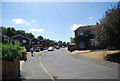
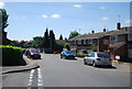
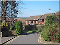
Photos of ME19 5RH


Area Information
Living in ME19 5RH offers a quiet, residential lifestyle in a small cluster of homes, with a population of 1,520 residents. This area is characterised by its compact nature, where daily life is shaped by proximity to local amenities and a strong sense of community. The demographic profile suggests a mature population, with a median age of 47 and most residents falling within the 30-64 age range. This makes ME19 5RH a place where families and established professionals coexist, often in owner-occupied homes. The area’s small size means that essential services and transport links are within practical reach, supporting a lifestyle that balances convenience with a low-key, stable environment. With no significant environmental constraints or planning restrictions, the area is free from the complexities often associated with protected landscapes or flood-prone zones. For those seeking a peaceful, manageable community with access to nearby retail, rail, and air travel, ME19 5RH provides a straightforward, no-frills setting.
- Area Type
- Postcode
- Area Size
- Not available
- Population
- 1520
- Population Density
- 5989 people/km²
The property market in ME19 5RH is defined by high home ownership (77%) and a focus on houses rather than flats or apartments. This suggests a market dominated by owner-occupied properties, likely attracting families or individuals seeking long-term stability. The absence of rental data means the area is not heavily reliant on the private lettings sector, which could indicate lower demand for short-term tenancies. The predominance of houses may appeal to buyers seeking space and privacy, though the small size of the postcode means the housing stock is limited. For prospective buyers, this implies a need to look beyond the immediate area for more options, but the existing properties are likely to be in good condition, given the low crime risk and lack of environmental constraints. The market is likely to be competitive for those seeking a home in this specific postcode, but the lack of planning restrictions could make it easier to adapt or extend properties.
House Prices in ME19 5RH
No properties found in this postcode.
Energy Efficiency in ME19 5RH
Residents of ME19 5RH have access to a range of local amenities within practical reach. The area is served by five retail outlets, including Tesco Larkfield, Morrisons Daily, and Morrisons Leybourne, ensuring everyday shopping needs are met. The presence of five railway stations—West Malling, New Hythe, and East Malling—provides reliable commuting options to nearby towns. For travel beyond the region, Rochester Airport is nearby, offering flight connections. While the area does not have major parks or leisure facilities listed, the absence of protected natural sites means residents are not restricted by environmental constraints. The combination of retail, rail, and air travel supports a lifestyle that balances convenience with accessibility. The small scale of the postcode means the community feels close-knit, with amenities tailored to local needs rather than large-scale developments.
Amenities
Schools
| Rank | School | Type | Entry gender | Ages |
|---|
Explore more schools in this area
Go to Schools tabDemographics
The community in ME19 5RH is predominantly composed of adults aged 30-64, reflecting a median age of 47. This suggests a population that is largely settled, with fewer young families or retirees compared to other areas. Home ownership is high, with 77% of residents living in their own homes, indicating a stable, long-term presence. The accommodation type is exclusively houses, which is uncommon in many urban areas but aligns with the rural or semi-rural character of the postcode. The predominant ethnic group is White, though no specific data on minority representation is provided. The absence of significant deprivation metrics in the data implies that the area’s quality of life is supported by adequate housing, services, and infrastructure. This demographic profile suggests a community focused on stability, with limited turnover and a strong emphasis on property ownership.
Household Size
Accommodation Type
Tenure
Ethnic Group
Religion
Household Composition
Age
Household Deprivation
NS-SEC
Explore more demographic insights in this area
Go to Demographics tabPlanning
Planning Constraints
- Flood RiskPremium
- Ramsar Wetland SitesPremium
- Area of Outstanding Natural BeautyPremium
- Protected Nature ReservePremium
- Protected WoodlandPremium