Area Overview for ME19 4TB
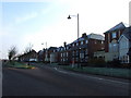
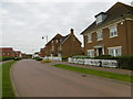
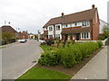
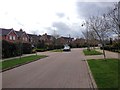
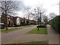
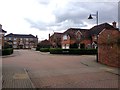
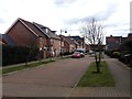
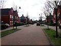
Photos of ME19 4TB


Area Information
Living in ME19 4TB means being part of a small, tightly knit residential cluster in England, home to 1,732 people. This area is characterised by its modest scale and proximity to practical amenities, making it a convenient base for those seeking a balanced lifestyle. The community is predominantly composed of adults aged 30–64, reflecting a mature demographic with established roots. Daily life here is shaped by the area’s low crime risk, with a safety score of 77, and reliable digital connectivity, including broadband rated 89 and mobile coverage at 81. The absence of environmental constraints, such as protected woodlands or Ramsar sites, means development and living here is straightforward. Residents benefit from nearby rail links, including West Malling and East Malling stations, which provide easy access to surrounding towns. While the area is small, it offers a quiet, stable environment with a focus on family-oriented living, supported by local schools and retail options. For those prioritising safety, convenience, and a manageable population, ME19 4TB presents a compelling case.
- Area Type
- Postcode
- Area Size
- Not available
- Population
- 1732
- Population Density
- 3172 people/km²
ME19 4TB is primarily an owner-occupied area, with 80% of homes owned by residents rather than rented. The accommodation type is predominantly houses, which is unusual for areas with high rental markets. This suggests a community focused on family homes and long-term residency, with properties likely to be larger and more traditional in style. The high home ownership rate may indicate a stable property market, where buyers are more likely to invest in permanent residences rather than short-term rentals. For those considering the area, the limited number of properties—given the small population—means competition could be low, but the emphasis on houses may appeal to those seeking space and privacy. The absence of rental data means it’s unclear whether the area also attracts tenants, but the data points to a market where ownership is the dominant model.
House Prices in ME19 4TB
No properties found in this postcode.
Energy Efficiency in ME19 4TB
Residents of ME19 4TB have access to a range of local amenities, including retail options such as Waitrose Little, Asda Kingshill, and Aldi Alexander Grove. These stores provide convenience for daily shopping, from groceries to household essentials. The presence of multiple retail outlets suggests a practical approach to meeting residents’ needs without requiring long trips. While the data does not specify dining or leisure facilities, the rail stations nearby—West Malling, Wateringbury, and East Malling—offer connections to larger towns with more extensive options. The area’s small size means that amenities are concentrated, encouraging a walkable or short-driving lifestyle. This balance of local retail and transport links contributes to a lifestyle that prioritises convenience and accessibility for everyday living.
Amenities
Schools
The nearest school to ME19 4TB is Kings Hill School Primary and Nursery, which holds an outstanding Ofsted rating. This primary school serves the local community, offering education for younger children and providing a foundation for families seeking quality schooling. The presence of a single primary school suggests that secondary education options may be located further afield, requiring families to plan for commuting to larger towns. However, the outstanding rating indicates a high standard of teaching and facilities, which is a significant advantage for parents prioritising education. The lack of secondary schools in the immediate area means prospective buyers should consider proximity to other educational institutions when evaluating the area’s suitability for their needs.
| Rank | School | Type | Entry gender | Ages |
|---|
Explore more schools in this area
Go to Schools tabDemographics
The population of ME19 4TB is 1,732, with a median age of 47, indicating a community skewed toward middle-aged adults. The most common age range is 30–64, suggesting a stable, established population with fewer young families or retirees. Home ownership is high, at 80%, and the predominant accommodation type is houses, reflecting a suburban or semi-rural character. The predominant ethnic group is White, which aligns with the broader demographic trends of the region. This composition implies a community with long-term residency patterns, where property ownership is the norm. The absence of specific data on deprivation or diversity means the area’s social dynamics are not explicitly detailed, but the high home ownership rate and mature age profile suggest a low turnover of residents and a focus on long-term stability.
Household Size
Accommodation Type
Tenure
Ethnic Group
Religion
Household Composition
Age
Household Deprivation
NS-SEC
Explore more demographic insights in this area
Go to Demographics tabPlanning
Planning Constraints
- Flood RiskPremium
- Ramsar Wetland SitesPremium
- Area of Outstanding Natural BeautyPremium
- Protected Nature ReservePremium
- Protected WoodlandPremium