Area Overview for ME18 6HW
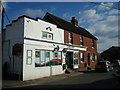
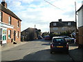
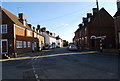
Photos of ME18 6HW


Area Information
ME18 6HW is a small, tightly knit residential postcode in England, home to 1,549 people spread across a compact area with a population density of 461 people per square kilometre. This is a community of established adults, with a median age of 47 and the majority of residents falling within the 30–64 age range. The area is characterised by a strong sense of local identity, with 71% of homes owned by their occupants, suggesting a stable, long-term population. Daily life here is defined by proximity to essential services and a low crime rate, which contributes to a sense of security. The presence of nearby rail stations and retail outlets ensures practicality for commuting and shopping. While the area is small, it offers a balance of residential tranquility and access to regional amenities. For those seeking a place with a mature demographic, strong home ownership, and minimal environmental constraints, ME18 6HW presents a straightforward option.
- Area Type
- Postcode
- Area Size
- Not available
- Population
- 1549
- Population Density
- 461 people/km²
ME18 6HW is a predominantly owner-occupied area, with 71% of properties owned by their residents. This suggests a market skewed towards long-term homeownership rather than rental activity, which can stabilise property values and reduce turnover. The accommodation type here is primarily houses, which are often associated with family living or single occupants seeking space and privacy. Given the small size of the postcode, the housing stock is likely limited, meaning buyers may need to consider nearby areas for more options. The high home ownership rate also indicates that the area is not a hotspot for speculative investment or short-term lets. For buyers, this translates to a market where properties are likely to remain in the same hands for years, offering potential for long-term equity growth. However, the limited number of homes may mean competition for available properties, particularly for those seeking specific features.
House Prices in ME18 6HW
No properties found in this postcode.
Energy Efficiency in ME18 6HW
The lifestyle in ME18 6HW is shaped by its proximity to practical amenities. Residents can access five rail stations, including Yalding and Beltring, which provide easy access to regional transport. For retail needs, the area is served by Co-op Petrol, Co-op East, and Tesco Coxheath, offering a range of shopping and fuel options. While there are no parks or leisure facilities explicitly listed, the presence of nearby rail stations and retail outlets suggests a community focused on convenience and connectivity. The absence of detailed information on recreational spaces means that those prioritising green spaces or cultural amenities may need to look beyond the immediate area. Nonetheless, the practical layout of ME18 6HW ensures that daily life is efficient, with minimal need for long commutes or extensive travel for essentials.
Amenities
Schools
The nearest school to ME18 6HW is Yalding, St Peter and St Paul Church of England Voluntary Controlled Primary School, which serves the local community with a good Ofsted rating. This primary school is a key asset for families with young children, providing a reliable educational foundation. However, the absence of secondary schools within the area means parents may need to look further afield for secondary education. The presence of a single, well-rated primary school suggests that the area is suitable for families with young children but may require additional planning for older students. The school’s voluntary controlled status indicates it is a Church of England institution, which may align with specific educational or cultural preferences. Overall, the school infrastructure in ME18 6HW is adequate for primary education but limited in scope for broader educational needs.
| Rank | School | Type | Entry gender | Ages |
|---|
Explore more schools in this area
Go to Schools tabDemographics
The population of ME18 6HW is predominantly adults aged 30–64, with a median age of 47. This suggests a community of middle-aged residents, many of whom may be in their peak working years or nearing retirement. Home ownership is high at 71%, indicating a preference for long-term residency over rental properties. The area is composed mainly of houses, which aligns with the demographic profile of families or individuals seeking stable, permanent housing. The predominant ethnic group is White, reflecting a homogenous population. While no specific data on deprivation is provided, the high home ownership and low crime rate imply a relatively stable socioeconomic environment. This stability may support quality of life, with fewer pressures from housing insecurity or crime. The absence of significant demographic diversity, however, means the community may lack the cultural variety found in more ethnically mixed areas.
Household Size
Accommodation Type
Tenure
Ethnic Group
Religion
Household Composition
Age
Household Deprivation
NS-SEC
Explore more demographic insights in this area
Go to Demographics tabPlanning
Planning Constraints
- Flood RiskPremium
- Ramsar Wetland SitesPremium
- Area of Outstanding Natural BeautyPremium
- Protected Nature ReservePremium
- Protected WoodlandPremium