Area Overview for ME1 2JT
Photos of ME1 2JT


Area Information
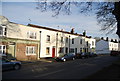
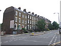
Living in ME1 2JT offers a quiet, residential lifestyle in a small cluster of homes with a population of 1751. The area is defined by its compact size and proximity to key transport links, including multiple railway stations and a nearby airport. Residents here are predominantly adults aged 30-64, reflecting a mature, settled community. Daily life is characterised by low crime rates and minimal environmental risks, with no flood zones, protected woodlands, or natural beauty areas affecting the area. The presence of St Peter’s Infant School, rated good by Ofsted, ensures young families have access to quality primary education. While the area lacks secondary schools, its rail connectivity and retail options, such as Spar and Co-op stores, provide practical convenience. ME1 2JT is ideal for those seeking a low-maintenance, safe environment with easy access to commuting routes and essential services. Its small size means the community feels close-knit, with homes primarily owner-occupied and focused on family living.
- Area Type
- Postcode
- Area Size
- Not available
- Population
- 1751
- Population Density
- 8346 people/km²
The property market in ME1 2JT is dominated by owner-occupied homes, with 68% of residents living in properties they own. This high home ownership rate suggests a stable market with long-term residents rather than a transient rental population. The area’s accommodation is primarily houses, which is typical for smaller, low-density residential clusters. Given the small population and limited housing stock, the market is likely constrained, with limited scope for new developments. Buyers should consider that the area’s size means competition for properties may be fierce, and availability is likely to be limited. The focus on houses rather than flats or apartments may appeal to families seeking space, but it also means the area is not suited to those prioritising high-density living. For those seeking a secure, low-maintenance home, ME1 2JT’s property market offers a niche opportunity, though its small size means buyers must act decisively.
House Prices in ME1 2JT
No properties found in this postcode.
Energy Efficiency in ME1 2JT
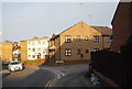
Residents of ME1 2JT have access to a range of practical amenities within reach. Retail options include Spar and Co-op stores, such as Co-op Dickens and Co-op Delce, offering everyday shopping needs. The area’s rail stations—Chatham, Rochester, and Strood—provide direct links to broader transport networks, while Rochester Airport offers additional travel flexibility. Though the data does not mention parks or leisure facilities, the absence of environmental constraints like protected woodlands or AONB areas suggests open spaces may be available nearby. The combination of retail, transport, and air connectivity creates a convenient lifestyle, ideal for those prioritising accessibility over large-scale leisure options. For families, the proximity to St Peter’s Infant School and the low crime rate further enhance the area’s appeal as a practical, secure place to live.
Amenities
Schools
The nearest school to ME1 2JT is St Peter’s Infant School, a primary school with a good Ofsted rating. This provides a reliable option for families with young children, though no secondary schools are listed in the data. The presence of a primary school with a good rating is a strong point for families prioritising education, but those requiring secondary schooling will need to look further afield. The absence of additional schools in the immediate area suggests that parents may need to plan for commuting to larger towns or cities for secondary education. For those valuing proximity to schools, St Peter’s Infant School offers a solid foundation, but the lack of secondary options should be considered in long-term family planning.
| Rank | School | Type | Entry gender | Ages |
|---|
Explore more schools in this area
Go to Schools tabDemographics
ME1 2JT has a median age of 47, with the majority of residents falling within the 30-64 age range. This suggests a community of working-age adults and older families, likely with established careers and long-term residency. Home ownership is high at 68%, indicating a stable, owner-occupied demographic rather than a rental-heavy area. The accommodation types here are predominantly houses, which aligns with the area’s residential character and lower population density. The predominant ethnic group is White, though no further breakdown of diversity is provided. With a population of 1751, the area is small enough to foster a tight-knit community but not so isolated that it lacks essential services. The absence of specific data on deprivation or income levels means the quality of life remains unquantified, but the low crime score and minimal environmental constraints suggest a generally comfortable living standard.
Household Size
Accommodation Type
Tenure
Ethnic Group
Religion
Household Composition
Age
Household Deprivation
NS-SEC
Explore more demographic insights in this area
Go to Demographics tabPlanning
Planning Constraints
- Flood RiskPremium
- Ramsar Wetland SitesPremium
- Area of Outstanding Natural BeautyPremium
- Protected Nature ReservePremium
- Protected WoodlandPremium