Area Overview for Littlemore
Photos of Littlemore
Area Information
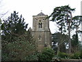
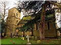
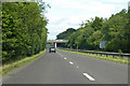
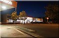
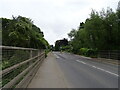
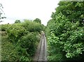
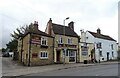
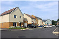
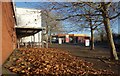
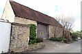
Littlemore is a district situated approximately 3 miles southeast of Oxford city centre, covering an area of just 1.9 km². This location places the neighbourhood near the River Thames while maintaining a distinct separation from the surrounding urban sprawl. Originally part of the parish of St Mary the Virgin, Littlemore developed as a rural hamlet before becoming a separate ecclesiastical parish in 1847. Extensive development occurred from the 1920s onwards, transforming a historical setting into a modern residential community. The area retains significant historical weight, having served as the site of St Nicholas' Priory in the 12th century and later home to John Henry Newman, who lived at 'The College' in the mid-19th century. Today, the conservation area designates since 1992 protects 15th–18th-century manor houses and farmhouses alongside St Mary and St Nicholas Church. Residents benefit from proximity to the A4144 road, which links directly to Oxford, while the former Littlemore railway station marked the end of a passenger line closed in 1963. Living in Littlemore means inhabiting a space where medieval priory foundations coexist with suburban homes. The small footprint of the district concentrates local amenities and creates a tight-knit environment. Access to bus services connects you easily to Oxford city centre, ensuring daily commutes remain straightforward for those working further afield.
- Area Type
- District Borough Unitary Ward
- Area Size
- 1.9 km²
- Population
- Not available
- Population Density
- Not available
Demographics
The community within Littlemore reflects a mature population profile, with a median age of 70 years. This demographic shift indicates a dominant presence of older residents compared to the national average. While specific breakdowns for age ranges appear limited in current records, the overall median age signals a shift away from young families towards retirees or long-term residents. Approximately 51% of households own their homes, suggesting a balanced split between owner-occupiers and private or social renters. The remainder of the 100% of households consists of those who do not own their property outright, potentially comprising tenants or those in shared ownership schemes. Data on the predominant ethnic group and religious affiliations are not specified in the available records, though the historical Catholic connection to John Henry Newman remains a notable feature of the area's identity. Household composition details are aggregated in the total figures provided. The demographic structure suggests a quiet, established neighbourhood where daily life revolves around established routines rather than transient trends. Those considering homes in Littlemore should be aware that the shopper demographic likely favours convenience and stability over high-energy youth culture. The area's composition supports a slower pace of life suitable for retirement or those seeking a settled domestic environment away from the city centre hustle.
Household Size
Accommodation Type
Tenure
Ethnic Group
Religion
Household Composition
Age
Household Deprivation
NS-SEC
Explore more demographic insights in this area
Go to Demographics tabPlanning
Planning Constraints
- Flood RiskPremium
- Ramsar Wetland SitesPremium
- Area of Outstanding Natural BeautyPremium
- Protected Nature ReservePremium
- Protected WoodlandPremium
- Crime RiskPremium