Area Overview for Lavendon
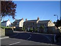
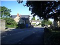
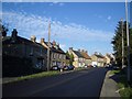
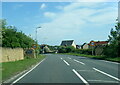
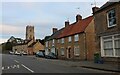
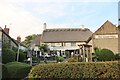
Photos of Lavendon


Area Information
Living in Lavendon offers a distinct residence within a defined built-up environment. This area covers approximately 43.8 hectares and stands as a settled community in England. You will find a location that is established and familiar to those seeking stability. The neighbourhood classification places it among built-up towns where daily life follows a predictable local rhythm. Residents benefit from a clear geographical boundary that defines the scope of their immediate surroundings. This setting supports a lifestyle centred on local convenience rather than sprawling expansion. The area represents a solid foundation for homeownership, reflecting a demographic eager to settle down. Prospective buyers often look here for a specific type of established neighbourhood rather than a developing site. The character of Lavendon is shaped by its modest size and clear urban identity. Living in this specific spot means accessing a community with a long history of residence. The area does not promise rapid change or dramatic redevelopment but offers comfort and continuity. You can expect a environment where the local footprint remains consistent over time. This stability appeals to families and individuals who prioritise a known setting for their home.
- Area Type
- Built Up Area 250
- Area Size
- 43.8 hectares
- Population
- Not available
- Population Density
- Not available
Daily life in Lavendon revolves around a compact set of amenities within practical reach. You can access five retail outlets located nearby, providing sufficient variety for most shopping needs. Specific venues available to you include Aldi on Worcester Way and branches of Sainsburys and Tesco both situated in Olney. This mix ensures you find major supermarket chains without travelling far. These retail locations handle your weekly grocery requirements and general household shopping efficiently. The presence of a dedicated retail category indicates a deliberate focus on supporting the residents of this built-up area. Dining options are not detailed in the data, so you should plan for supermarket purchasing alongside local visitation. You will find that the immediate vicinity focuses on essential goods rather than a diverse range of restaurants. The life here is practical, anchored by the reliability of these major stores. Residents of Lavendon appreciate knowing they can rely on familiar brands for their purchases. The proximity of Olney and the Worcester Way location integrates these shops into the daily routine. Lifestyle choices depend heavily on this immediate access to fresh food and household essentials. The five stores within reach define the commercial character of your neighbourhood. You will conduct most errands with these specific retailers in mind. This setup suits an older demographic that values convenience and accessibility over novelty.
Amenities
Schools
Educational provision in Lavendon centres on a single specific institution that serves the locality. Lavendon School operates on two distinct status levels within the data. It functions as a primary school where young children begin their formal education. It also holds the designation of an academy with a 'good' Ofsted rating for its performance. This dual status means parents enjoy a reliable educational path for their younger children without needing to travel far for a primary placement. The school type mix is straightforward, offering only primary and academy education within the immediate vicinity. You will not find secondary schools listed in the data for this specific area, so older children will need to look beyond Lavendon for their secondary education. The 'good' rating provides a concrete assurance of quality for the families with young children living in the 43.8-hectare zone. The presence of one school name eliminates choice and creates a unified community standard. Parents in Lavendon know exactly which institution educates the bulk of the local youth. The academy status implies a level of autonomy and modern management often sought by local councils. Living in Lavendon guarantees access to this specific primary academy. While the range of school options is limited to this single entity, its rating ensures a baseline of quality. Families must plan for secondary education externally, but primary schooling is secure and well-rated.
| Rank | School | Type | Entry gender | Ages |
|---|
Explore more schools in this area
Go to Schools tabDemographics
The community in Lavendon reflects a mature population structure with significant implications for household composition. The median age stands at 70 years, indicating a largely older demographic resides in this neighbourhood. Most residents fall into the total age bracket, suggesting a population that has settled permanently. Seventy-seven per cent of households own their homes, a stark contrast to the rental markets found in larger cities. This high ownership rate signals long-term commitment from the people calling Lavendon home. The area lacks a specific predominant ethnic group designation in the available records, pointing to a homogenous or unrecorded ethnic makeup. Religious affiliations are also not itemised, but the overall picture remains one of steady local families. You will not find a transient workforce; instead, you encounter neighbours who have lived here for decades. The household composition remains consistent with this older average age. Deprivation levels are not calculated for this specific zone, but the home ownership figure suggests financial stability among residents. The community feels rooted, with few temporary occupants moving through the streets. This demographic profile offers a quiet atmosphere where the primary neighbours are likely retired individuals or older families. Living here means joining a group that values permanence over mobility.
Household Size
Accommodation Type
Tenure
Ethnic Group
Religion
Household Composition
Age
Household Deprivation
NS-SEC
Explore more demographic insights in this area
Go to Demographics tabPlanning
Planning Constraints
- Crime RiskPremium