Area Overview for KT8 2UR
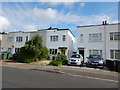
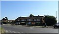
Photos of KT8 2UR


Area Information
KT8 2UR is a small, tightly knit residential cluster in England with a population of 2008 residents. This area is characterised by its quiet, family-oriented atmosphere, with a median age of 47 and a majority of adults aged 30–64. The community is predominantly home-owning, with 68% of properties occupied by owners, and most homes are traditional houses. Living here offers proximity to key amenities, including primary schools, rail networks, and ferry services. The area’s compact size means residents benefit from a sense of familiarity, with local shops, transport links, and green spaces within easy reach. Its location near London Heathrow Airport and major rail routes like the Hounslow Central Station adds convenience for commuters. The low crime risk and absence of environmental constraints make it an appealing choice for those seeking a stable, well-connected neighbourhood without the pressures of urban density.
- Area Type
- Postcode
- Area Size
- Not available
- Population
- 2008
- Population Density
- 6486 people/km²
KT8 2UR is primarily an owner-occupied area, with 68% of properties owned by residents rather than rented. The housing stock consists mainly of houses, which is typical for smaller, residential clusters. This suggests a focus on family homes rather than apartments or high-density developments. The limited population size means the property market is likely small, with fewer options available for buyers. However, the proximity to major transport routes, including rail stations and Heathrow Airport, may attract commuters or those seeking a balance between suburban living and urban accessibility. For buyers, the area’s compact nature means competition for available properties could be keen, but the absence of planning constraints or environmental restrictions makes it a straightforward market. The emphasis on houses also implies potential for larger, more private living spaces compared to other areas with higher apartment turnover.
House Prices in KT8 2UR
No properties found in this postcode.
Energy Efficiency in KT8 2UR
Living in KT8 2UR provides access to a range of practical amenities within reach. Local retail options include Sainsburys West Molesey, Tesco West, and Tesco East, offering everyday shopping needs. The area’s proximity to ferry services like Hampton Ferry Landing and Hampton Court Pier adds recreational and transport flexibility. Rail and metro stations such as Hounslow Central and Hatton Cross ensure efficient travel, while Heathrow Airport is a short distance away. For leisure, the nearby Moulsey ferry and Hampton Court Pier suggest opportunities for water-based activities or scenic outings. The combination of retail, transport, and nearby green spaces creates a lifestyle that balances convenience with the ability to explore beyond the immediate neighbourhood, supporting both daily routines and weekend escapes.
Amenities
Schools
The nearest school to KT8 2UR is St Barnaba’s RC First School, a primary institution serving the local community. No secondary schools are listed in the data, so families with older children may need to look beyond the immediate area for secondary education. The presence of a primary school indicates the area is well-suited for families with young children, offering a local option for early education. However, the lack of detailed Ofsted ratings or school performance data means prospective buyers must conduct further research to assess educational quality. For those prioritising proximity to schools, St Barnaba’s provides a foundational resource, though the absence of secondary options may influence decisions about long-term family needs.
| Rank | School | Type | Entry gender | Ages |
|---|
Explore more schools in this area
Go to Schools tabDemographics
The population of KT8 2UR is predominantly adults aged 30–64, reflecting a mature community with a median age of 47. Home ownership is high at 68%, indicating a stable, long-term resident base. The area is largely composed of houses, suggesting a focus on family-friendly living. The predominant ethnic group is White, though specific data on diversity or deprivation is not provided. The age profile suggests a mix of established families and professionals, with fewer young families or retirees compared to other areas. This demographic balance likely influences local services, with amenities tailored to adult needs such as schools, transport, and retail. The absence of detailed diversity metrics means the community’s cultural composition remains less defined in the data, but the high home ownership rate and age range imply a cohesive, settled population.
Household Size
Accommodation Type
Tenure
Ethnic Group
Religion
Household Composition
Age
Household Deprivation
NS-SEC
Explore more demographic insights in this area
Go to Demographics tabPlanning
Planning Constraints
- Flood RiskPremium
- Ramsar Wetland SitesPremium
- Area of Outstanding Natural BeautyPremium
- Protected Nature ReservePremium
- Protected WoodlandPremium