Area Overview for KT21 1QA
Photos of KT21 1QA


Area Information
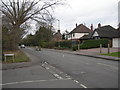
KT21 1QA is a small residential postcode area in England, home to 1,572 people. It is a compact cluster of homes, likely centred around a quiet, low-density neighbourhood. The area’s population suggests a tight-knit community, with a median age of 47 and a majority of residents aged between 30 and 64. This demographic indicates a mature population, possibly with families or professionals in their middle years. Daily life here is likely characterised by a balance between local amenities and proximity to nearby towns. The area’s safety profile is strong, with a crime risk score of 89, reflecting below-average crime rates. Its small size means residents may rely on nearby towns for broader services, but the presence of multiple rail stations and retail outlets within reach offers convenience. KT21 1QA is not a sprawling suburb but a focused, manageable community, ideal for those seeking a stable, low-risk environment with a clear sense of local identity.
- Area Type
- Postcode
- Area Size
- Not available
- Population
- 1572
- Population Density
- 1877 people/km²
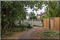
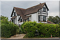
KT21 1QA is primarily an owner-occupied area, with 75% of properties in private hands. This high rate of home ownership suggests a community of long-term residents rather than a transient rental market. The accommodation type is predominantly houses, which is unusual for smaller postcode areas and may indicate a focus on family-friendly or larger homes. This housing stock implies that the area is not densely populated but offers more space per household. For buyers, this means the market is likely limited to individual properties rather than a broader selection, necessitating consideration of nearby areas for additional options. The prevalence of houses also suggests that the area may cater to those seeking a quieter, more settled lifestyle, with less pressure from high-density development. However, the small size of KT21 1QA means property availability is constrained, requiring buyers to look beyond immediate surroundings for more choices.
House Prices in KT21 1QA
No properties found in this postcode.
Energy Efficiency in KT21 1QA
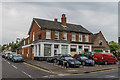
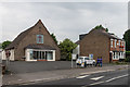
Living in KT21 1QA offers access to a range of amenities within practical reach. The area is served by five rail stations, including Ashtead and Leatherhead, providing straightforward commuting options to nearby towns. Retail choices are plentiful, with Tesco Ashtead, Tesco Leatherhead, and The Southern Co-operative Co offering everyday shopping needs. For those seeking leisure, the nearby Ditton Island Ferry Landing and Hampton Court Pier provide opportunities for water-based activities, though their use may depend on seasonal availability. The presence of multiple rail stations and retail outlets suggests a lifestyle that balances local convenience with connections to broader networks. While the area itself is small, its proximity to larger towns ensures residents are not isolated. The mix of transport and retail options supports a practical, accessible daily life, ideal for those who value both local and regional connectivity.
Amenities
Schools
| Rank | School | Type | Entry gender | Ages |
|---|
Explore more schools in this area
Go to Schools tabDemographics
The community in KT21 1QA is predominantly composed of adults aged 30 to 64, with a median age of 47. This suggests a population skewed towards middle-aged and older residents, likely with established careers and family ties. Home ownership is high, with 75% of properties owner-occupied, indicating a stable, long-term resident base. The accommodation type is primarily houses, which aligns with the area’s small, residential character and may appeal to those seeking more space than flats. The predominant ethnic group is White, reflecting a homogenous demographic profile. While this data does not provide direct insight into deprivation levels, the high home ownership and low crime risk suggest a generally secure and economically stable area. The absence of specific diversity metrics means the community’s social composition remains largely defined by its dominant demographic group.
Household Size
Accommodation Type
Tenure
Ethnic Group
Religion
Household Composition
Age
Household Deprivation
NS-SEC
Explore more demographic insights in this area
Go to Demographics tabPlanning
Planning Constraints
- Flood RiskPremium
- Ramsar Wetland SitesPremium
- Area of Outstanding Natural BeautyPremium
- Protected Nature ReservePremium
- Protected WoodlandPremium