Area Overview for KT21 1NZ
Photos of KT21 1NZ


Area Information
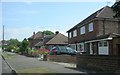
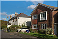
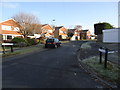
KT21 1NZ is a small, tightly knit residential postcode in England with a population of 1,361. It is a quiet, established area where the average age of residents is 47, reflecting a community dominated by adults aged 30–64. This is a place where homeownership is strong, with 68% of properties occupied by owners, suggesting a stable, long-term demographic. The area is characterised by its modest housing stock, with homes forming the majority of accommodation types. Daily life here is shaped by proximity to local amenities, including shops, rail services, and water-based transport links. The low flood risk and below-average crime rates further reinforce its appeal as a safe, low-stress environment. Residents benefit from excellent broadband connectivity, rated at the highest possible score, and practical access to nearby towns via railway stations. KT21 1NZ is ideal for those seeking a balance between residential tranquillity and connectivity to larger urban hubs, with a distinct local identity rooted in its small-scale community.
- Area Type
- Postcode
- Area Size
- Not available
- Population
- 1361
- Population Density
- 2861 people/km²
The property market in KT21 1NZ is defined by a high rate of home ownership (68%) and a predominance of houses. This suggests a community where long-term residency is common, with fewer rental properties compared to other areas. The small size of the postcode means the housing stock is limited, but the presence of nearby towns and rail links offers buyers access to a broader range of properties. The focus on owner-occupied homes indicates a market where investment in property is a key priority, though this also means competition for available listings may be keen. For buyers, the area’s compact nature means they should consider surrounding postcodes for more options. The absence of planning constraints, such as protected woodlands or wetlands, ensures flexibility in property use. However, the small scale of KT21 1NZ means it is best suited for those seeking a specific, established home rather than a growing or expanding market.
House Prices in KT21 1NZ
No properties found in this postcode.
Energy Efficiency in KT21 1NZ
Living in KT21 1NZ offers access to a range of practical amenities within easy reach. Retail options include M&S Woodcote BP, M&S Ashstead, and Tesco Ashtead, providing everyday shopping needs. Rail services are a key feature, with stations such as Ashtead, Epsom, and Tattenham Corner offering frequent connections to nearby towns and cities. For water-based travel, the Ditton Island Ferry Landing and Kingston Town End Pier provide links to local waterways. While the area is small, its proximity to these services ensures residents can access both urban and rural experiences. The presence of multiple retail and transport hubs suggests a community that values convenience without sacrificing the quiet charm of a smaller postcode. This balance makes KT21 1NZ appealing to those who want to live in a peaceful setting while maintaining easy access to larger centres for work, shopping, and recreation.
Amenities
Schools
| Rank | School | Type | Entry gender | Ages |
|---|
Explore more schools in this area
Go to Schools tabDemographics
The population of KT21 1NZ is predominantly adults aged 30–64, with a median age of 47. This suggests a mature, settled community with a strong presence of middle-aged households. Home ownership is high, at 68%, indicating a stable housing market where most residents are long-term occupants. The area is primarily composed of houses, which aligns with the demographic profile of established families and professionals. The predominant ethnic group is White, reflecting a homogenous community. While specific data on deprivation is not provided, the high home ownership rate and low crime risk imply a relatively high quality of life. The absence of significant planning constraints, such as protected nature reserves or AONB coverage, means residents face fewer restrictions on property development or lifestyle choices. This combination of factors creates a community that is both cohesive and practical for those prioritising stability and safety.
Household Size
Accommodation Type
Tenure
Ethnic Group
Religion
Household Composition
Age
Household Deprivation
NS-SEC
Explore more demographic insights in this area
Go to Demographics tabPlanning
Planning Constraints
- Flood RiskPremium
- Ramsar Wetland SitesPremium
- Area of Outstanding Natural BeautyPremium
- Protected Nature ReservePremium
- Protected WoodlandPremium