Area Overview for KT21 1BA
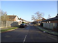
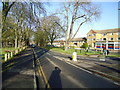
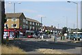
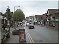
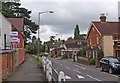
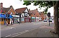
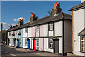
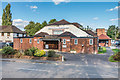
Photos of KT21 1BA


Area Information
KT21 1BA is a small, tightly knit residential postcode in England, home to 1,493 people. Its compact size means it’s a quiet, low-density area where daily life revolves around local amenities and easy access to transport. The community is predominantly composed of adults aged 30–64, with a median age of 47, suggesting a stable, mature population. This is a place where homeownership is the norm, with 77% of properties owned by residents, and the housing stock is largely composed of houses rather than flats. The area’s safety profile is strong, with a crime risk score of 77, placing it below the national average. Residents benefit from proximity to rail networks, including Ashtead, Leatherhead, and Epsom stations, and nearby retail hubs like Morrisons Daily and M&S Ashstead. KT21 1BA offers a blend of practicality and accessibility, making it appealing to those seeking a balanced lifestyle without the pressures of larger urban centres.
- Area Type
- Postcode
- Area Size
- Not available
- Population
- 1493
- Population Density
- 3529 people/km²
KT21 1BA is a largely owner-occupied area, with 77% of properties owned by residents. The housing stock is dominated by houses, which is unusual for smaller postcode areas and suggests a focus on family homes or larger properties. This composition indicates a market where long-term residency is common, with fewer rental properties. The limited size of the area means the housing stock is not extensive, so buyers should consider the proximity to amenities and transport networks. The presence of nearby rail stations, such as Ashtead and Epsom, adds value to properties, making them attractive to commuters. For buyers, the combination of homeownership and house-centric stock suggests a market that prioritises stability and space over high-density living.
House Prices in KT21 1BA
No properties found in this postcode.
Energy Efficiency in KT21 1BA
Living in KT21 1BA offers access to a range of local amenities, including five retail outlets such as The Southern Co-operative Co, Morrisons Daily, and M&S Ashstead. These shops provide everyday essentials, while nearby rail stations like Ashtead and Epsom offer links to broader networks. The Ditton Island Ferry Landing adds a unique touch, though its utility may depend on seasonal needs. The area’s small size means amenities are within walking or short driving distance, fostering a convenient, low-stress lifestyle. While the retail options are modest, they cater to daily needs without requiring long commutes. The character of the area is defined by its practicality, with a focus on accessibility over sprawling commercial centres.
Amenities
Schools
| Rank | School | Type | Entry gender | Ages |
|---|
Explore more schools in this area
Go to Schools tabDemographics
The population of KT21 1BA is 1,493, with a median age of 47. The majority of residents fall within the 30–64 age range, indicating a community of working-age adults and older professionals. Homeownership is high at 77%, reflecting a settled, long-term demographic. The area is predominantly composed of houses, which aligns with the age profile of its residents, many of whom may have families or seek more space. The predominant ethnic group is White, with no specific data provided on other groups. The absence of diversity statistics does not imply a lack of diversity but rather a focus on the primary demographic. The low median age and high homeownership suggest a community with strong economic stability and a preference for traditional housing.
Household Size
Accommodation Type
Tenure
Ethnic Group
Religion
Household Composition
Age
Household Deprivation
NS-SEC
Explore more demographic insights in this area
Go to Demographics tabPlanning
Planning Constraints
- Flood RiskPremium
- Ramsar Wetland SitesPremium
- Area of Outstanding Natural BeautyPremium
- Protected Nature ReservePremium
- Protected WoodlandPremium