Area Overview for KT19 8EY
Photos of KT19 8EY

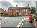
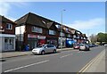
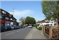
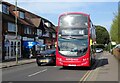
28 photos from this area
Area Information
Key information about the KT19 8EY including its size, population, and administrative classification.
- Area Type
- Postcode
- Area Size
- 3.1 hectares
- Population
- 1594
- Population Density
- 6456 people/km²
House Prices in KT19 8EY
58
Properties
£520,053
Average Sold Price
£138,000
Lowest Price
£875,000
Highest Price
Showing 58 properties
| Address | Type | Beds | Baths | Last Sale Price | Last Sale Date | |
|---|---|---|---|---|---|---|
| 51 Temple Road, Epsom, KT19 8EY | Semi-detached | 4 | 3 | £850,000 | Nov 2024 | |
| 81 Temple Road, Epsom, KT19 8EY | Maisonette | - | - | £652,000 | Feb 2024 | |
| 49 Temple Road, Epsom, KT19 8EY | house | - | - | £665,000 | Apr 2022 | |
| 73 Temple Road, Epsom, KT19 8EY | Detached | 3 | - | £670,000 | Jun 2021 | |
| 17 Temple Road, Epsom, KT19 8EY | Semi-detached | 3 | 2 | £580,000 | Apr 2021 | |
| 59 Temple Road, Epsom, KT19 8EY | Detached | 3 | 1 | £875,000 | Jan 2021 | |
| 27 Temple Road, Epsom, KT19 8EY | Semi-detached | 5 | 3 | £810,000 | Jun 2020 | |
| 45 Temple Road, Epsom, KT19 8EY | Semi-detached | 4 | 2 | £688,500 | Oct 2018 | |
| 57 Temple Road, Epsom, KT19 8EY | Detached | 3 | - | £645,000 | Mar 2017 | |
| 55 Temple Road, Epsom, KT19 8EY | Semi-detached | 4 | 2 | £650,000 | Sep 2016 |
Page 1 of 6
Energy Efficiency in KT19 8EY
Amenities
Schools
| Rank | School | Type | Entry gender | Ages |
|---|
Explore more schools in this area
Go to Schools tabDemographics
Household Size
Family (3-5 people)
most common
Accommodation Type
Houses
most common
Tenure
68
majority
Ethnic Group
White
most common
Religion
N/A
most common
Household Composition
N/A
most common
Age
47
median
Adults (30-64 years)
most common
Household Deprivation
N/A
with no deprivation
NS-SEC
37
in Lower managerial occupations
Explore more demographic insights in this area
Go to Demographics tabPlanning
Planning Constraints
- Flood RiskPremium
- Ramsar Wetland SitesPremium
- Area of Outstanding Natural BeautyPremium
- Protected Nature ReservePremium
- Protected WoodlandPremium