Area Overview for KT19 0QL
Photos of KT19 0QL


Area Information
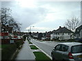
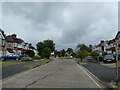
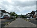
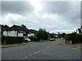
KT19 0QL is a small residential postcode area in England, home to 2,424 residents. It is a tightly knit community characterised by a predominance of houses, with 92% of properties owner-occupied. The area’s population skews towards adults aged 30–64, reflecting a mature, stable demographic. Daily life here is shaped by proximity to essential services and transport links, with a mix of retail, rail, and ferry access within reach. The postcode’s compact size means it is ideal for those seeking a balance between suburban comfort and urban connectivity. With low flood risk and a safety score of 89, it offers reassurance for families and professionals. The area’s appeal lies in its practicality—good broadband, reliable transport, and a quiet, established environment. For buyers, KT19 0QL represents a chance to own a home in a community with strong local ties and minimal environmental constraints.
- Area Type
- Postcode
- Area Size
- Not available
- Population
- 2424
- Population Density
- 4768 people/km²
KT19 0QL is almost entirely an owner-occupied area, with 92% of properties in private hands. This high rate of home ownership suggests a market dominated by long-term residents rather than renters, which can stabilise property values and reduce turnover. The accommodation type is exclusively houses, not flats or apartments, indicating a focus on family homes with gardens or larger living spaces. For buyers, this means the area is not suited to those seeking rental properties or smaller units. The compact nature of the postcode means the housing stock is limited, but the emphasis on owner-occupation suggests strong demand from local residents. Prospective buyers should consider the area’s small size and the likelihood of competition from existing homeowners. The absence of planning constraints or environmental restrictions further supports the feasibility of property investment here.
House Prices in KT19 0QL
No properties found in this postcode.
Energy Efficiency in KT19 0QL
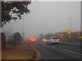
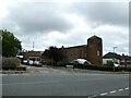
Living in KT19 0QL offers access to a range of nearby amenities that cater to daily needs. Retail options include Budgens Kingston, Co-op Ewell, and Aldi West, providing essentials within walking or short driving distance. For transport, residents can use Stoneleigh Railway Station, Worcester Park, and Tolworth Station for rail travel, while ferry services at Kingston Town End Pier and Ditton Island Ferry Landing offer alternative routes. Metro and tram stops at Morden and Merton Park link to broader networks. The area’s proximity to these services means residents can easily access shopping, dining, and leisure activities without long commutes. The mix of retail, transport, and connectivity contributes to a convenient, practical lifestyle, ideal for those valuing accessibility and efficiency in their daily routines.
Amenities
Schools
| Rank | School | Type | Entry gender | Ages |
|---|
Explore more schools in this area
Go to Schools tabDemographics
The community in KT19 0QL is predominantly composed of adults aged 30–64, with a median age of 47. This suggests a population of settled professionals and families, rather than students or younger renters. Home ownership is exceptionally high at 92%, indicating a long-term commitment to the area. All properties are houses, not flats, reflecting a preference for family-friendly living spaces. The predominant ethnic group is White, with no specific data on other demographics provided. The absence of deprivation data means the area’s quality of life can be inferred from its high home ownership and low crime risk. With 92% of residents owning their homes, the community likely enjoys a sense of stability and shared investment in local infrastructure. This demographic profile aligns with a mature, low-maintenance lifestyle, where residents prioritise security and established amenities.
Household Size
Accommodation Type
Tenure
Ethnic Group
Religion
Household Composition
Age
Household Deprivation
NS-SEC
Explore more demographic insights in this area
Go to Demographics tabPlanning
Planning Constraints
- Flood RiskPremium
- Ramsar Wetland SitesPremium
- Area of Outstanding Natural BeautyPremium
- Protected Nature ReservePremium
- Protected WoodlandPremium