Area Overview for KT17 4AG
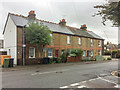
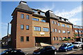
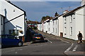
Photos of KT17 4AG


Area Information
KT17 4AG is a small residential postcode in England with a population of 1542, characterised by a compact cluster of homes. This area appeals to those seeking a settled community, with a median age of 47 and a majority of residents aged 30–64. The neighbourhood is predominantly owner-occupied, with 66% of homes owned by residents, and houses are the primary accommodation type. Daily life here balances suburban tranquillity with proximity to amenities. The area’s small size means it is tightly knit, with residents likely to know their neighbours. Its location offers practical access to nearby towns and services, making it suitable for families and professionals. The absence of major planning constraints or environmental restrictions ensures a straightforward living experience, free from complex regulatory hurdles. For buyers, KT17 4AG represents a blend of stability and convenience, with homes that reflect the area’s established character.
- Area Type
- Postcode
- Area Size
- Not available
- Population
- 1542
- Population Density
- 3301 people/km²
KT17 4AG is primarily an owner-occupied area, with 66% of homes owned by residents. The accommodation type is predominantly houses, which implies a mix of semi-detached, detached, or terraced properties typical of suburban settings. This contrasts with areas dominated by flats or rental properties, suggesting a more established, family-oriented housing stock. The small size of the postcode means the number of available homes is limited, potentially increasing competition for buyers. For those seeking property in this area, the focus is likely on existing homes rather than new developments. The lack of planning constraints or environmental restrictions also makes it easier to purchase without navigating complex regulations. Buyers should consider the limited inventory and the appeal of a stable, owner-occupied community when evaluating properties here.
House Prices in KT17 4AG
No properties found in this postcode.
Energy Efficiency in KT17 4AG
Living in KT17 4AG offers access to a variety of amenities within practical reach. Retail options include Lidl Upper, Co-op Epsom, and Sainsburys Kiln, providing everyday shopping needs. The area’s rail network, with stations such as Epsom and Ewell East, connects residents to broader transport links. Ferry landings like Kingston Turks Pier and Ditton Island Ferry Landing offer alternative travel routes. Metro stops such as Belgrave Walk Tram Stop add to the transport diversity. These amenities contribute to a convenient lifestyle, with easy access to shopping, transport, and leisure. The mix of retail, transport hubs, and proximity to nearby towns ensures residents can balance local convenience with broader connectivity, enhancing the practicality of daily life in this area.
Amenities
Schools
KT17 4AG is served by a range of schools, including state and independent options. Wallace Fields Infant School and Nursery is an academy with an outstanding Ofsted rating, offering early years education. Wallace Fields Junior School, a primary school with a good Ofsted rating, provides continuity for local children. Nearby, Little Downsend Epsom is an independent school, catering to families seeking private education. The mix of school types ensures flexibility for parents, whether they prioritise state education or prefer independent schooling. These institutions collectively support a family-friendly environment, with high standards reflected in their ratings. The proximity of these schools to homes in KT17 4AG enhances the area’s appeal for households with children, reducing commute times and ensuring access to quality education.
| Rank | School | Type | Entry gender | Ages |
|---|
Explore more schools in this area
Go to Schools tabDemographics
The community in KT17 4AG is predominantly composed of adults aged 30–64, with a median age of 47. This suggests a mature population, likely including professionals and families in their prime earning years. Home ownership is high at 66%, indicating a stable, long-term resident base. The area is largely composed of houses, which aligns with the demographic profile of older, established households. The predominant ethnic group is White, though no data is provided on other ethnicities or diversity metrics. The absence of specific deprivation data means the area’s quality of life can be inferred from its low crime risk and good digital connectivity. This demographic profile suggests a community focused on comfort, with residents prioritising property ownership and a settled lifestyle over transient rental arrangements.
Household Size
Accommodation Type
Tenure
Ethnic Group
Religion
Household Composition
Age
Household Deprivation
NS-SEC
Explore more demographic insights in this area
Go to Demographics tabPlanning
Planning Constraints
- Flood RiskPremium
- Ramsar Wetland SitesPremium
- Area of Outstanding Natural BeautyPremium
- Protected Nature ReservePremium
- Protected WoodlandPremium