Area Overview for KT16 8HE
Photos of KT16 8HE


Area Information
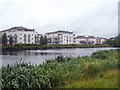
Living in KT16 8HE offers a quiet, residential experience in a small cluster of homes with a population of 1,898. This area is characterised by its modest scale, where daily life is shaped by proximity to essential services and a stable community. The median age of 47 suggests a predominantly middle-aged population, with most residents falling within the 30–64 age range. This demographic likely reflects a mix of established families and long-term residents, contributing to a sense of continuity. KT16 8HE is not a sprawling suburb but a focused neighbourhood, making it easy to navigate on foot or by bike. Its location near multiple rail stations and ferry landings adds to its practicality, while the presence of primary schools ensures families have access to education. The area’s low flood risk and absence of protected natural sites mean it avoids the constraints of more environmentally sensitive regions. However, its modest size means it is best suited for those seeking a compact, well-served community rather than expansive living.
- Area Type
- Postcode
- Area Size
- Not available
- Population
- 1898
- Population Density
- 4353 people/km²
KT16 8HE is predominantly an owner-occupied area, with 72% of homes owned by residents rather than rented. This suggests a community of long-term residents, many of whom may have purchased properties as family homes. The accommodation type is exclusively houses, which is unusual for areas with higher rental markets. This mix of ownership and housing stock indicates a focus on semi-detached or detached properties, likely catering to families seeking space and privacy. Given the area’s small size, the housing stock is limited, meaning buyers may need to consider nearby postcode areas for more options. The high home ownership rate also implies a stable property market, with prices potentially reflecting the area’s desirability for its practical amenities and safety profile. For buyers, this means a focus on established homes rather than new developments, with little scope for speculative investment.
House Prices in KT16 8HE
No properties found in this postcode.
Energy Efficiency in KT16 8HE
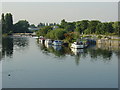
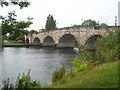
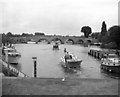
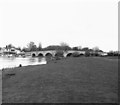
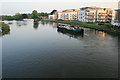
Residents of KT16 8HE enjoy access to a range of practical amenities within walking or short driving distance. The area includes five retail outlets, such as Tesco Chertsey and Budgens Shell, providing everyday shopping needs. Three rail stations—Chertsey, Addlestone, and Shepperton—offer regular services to London and nearby towns, while four ferry landings, including Shepperton and Moulsey, provide scenic transport options along the Thames. Proximity to Fairoaks Airport and London Heathrow Airport ensures easy travel, and the Heathrow Central Bus Station adds to the area’s connectivity. Although the data does not specify parks or leisure facilities, the presence of multiple transport hubs and retail options suggests a lifestyle focused on convenience and accessibility. The mix of retail, transport, and travel options makes KT16 8HE well-suited for those prioritising practicality over expansive leisure spaces.
Amenities
Schools
Residents of KT16 8HE have access to two primary schools within practical reach: StepGates Community School and StepGates First School. Both institutions cater to younger children, with StepGates Community School holding a ‘Good’ Ofsted rating, indicating a reliable standard of education. The presence of two primary schools in close proximity is a significant advantage for families, reducing the need for long commutes. However, the data does not include secondary schools, which may require residents to travel further. The mix of schools suggests a focus on early education, which aligns with the area’s predominantly middle-aged population and family-oriented demographics. For parents, the availability of primary schools within walking distance enhances the area’s appeal, though further research would be needed to assess secondary education options.
| Rank | School | Type | Entry gender | Ages |
|---|
Explore more schools in this area
Go to Schools tabDemographics
KT16 8HE has a median age of 47, with 72% of residents owning their homes. This high home ownership rate indicates a stable, long-term population, with most households likely being families or individuals in their prime working years. The predominant age group, 30–64 years, suggests a community focused on established careers and family life. The accommodation type is primarily houses, which aligns with the area’s residential character and the absence of high-density housing. The predominant ethnic group is White, reflecting a homogenous demographic profile. While this data does not include specific information on deprivation or diversity beyond ethnicity, the age and ownership figures imply a relatively affluent, settled population. The absence of detailed diversity metrics means the community’s full composition remains partially unexplored, but the existing data underscores a cohesive, middle-aged demographic with strong ties to property ownership.
Household Size
Accommodation Type
Tenure
Ethnic Group
Religion
Household Composition
Age
Household Deprivation
NS-SEC
Explore more demographic insights in this area
Go to Demographics tabPlanning
Planning Constraints
- Flood RiskPremium
- Ramsar Wetland SitesPremium
- Area of Outstanding Natural BeautyPremium
- Protected Nature ReservePremium
- Protected WoodlandPremium