Area Overview for KT11 2WW
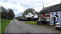
Photos of KT11 2WW


Area Information
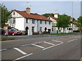
KT11 2WW is a small, tightly knit residential cluster in England, home to 1,592 people. Its compact size fosters a quiet, community-oriented atmosphere, with most residents living in owner-occupied houses. The area’s median age of 47 suggests a stable population, with adults aged 30–64 forming the majority. This demographic balance creates a mature, low-traffic environment, ideal for those seeking a settled lifestyle. Proximity to key amenities like Waitrose Cobham and Sainsburys Cobham ensures daily needs are met locally, while rail links to Cobham & Stoke d’Abernon and Oxshott stations provide easy access to nearby towns. The low crime risk score of 84 and absence of flood or environmental hazards make it a safe, practical choice for buyers prioritising security and reliability. With broadband quality rated excellent (91/100) and mobile coverage good (85/100), residents enjoy seamless connectivity for work and leisure. KT11 2WW is a microcosm of suburban comfort, blending convenience with tranquillity.
- Area Type
- Postcode
- Area Size
- Not available
- Population
- 1592
- Population Density
- 1647 people/km²
KT11 2WW is primarily an owner-occupied area, with 75% of properties owned by residents rather than rented. The housing stock is dominated by houses, indicating a preference for larger, family-friendly homes. This contrasts with areas where flats or apartments predominate, suggesting a demographic that values private space and land. The small size of the postcode area means the property market is limited in scale, with buyers likely to consider nearby neighbourhoods for more options. The high home ownership rate implies a stable market, with fewer rental properties available. For buyers, this means a focus on purchasing rather than renting, though the proximity to retail hubs like Waitrose Cobham and rail stations may enhance property desirability. The lack of planning constraints or protected areas also makes it easier to modify or expand homes, which could be a draw for those seeking flexibility.
House Prices in KT11 2WW
No properties found in this postcode.
Energy Efficiency in KT11 2WW
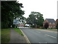
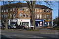
Living in KT11 2WW offers a mix of convenience and accessibility. Residents have retail options within reach, including Waitrose Cobham and Sainsburys Cobham, ensuring fresh groceries and household essentials are easily obtainable. Rail stations like Cobham & Stoke d’Abernon and Oxshott provide direct links to nearby towns, while ferry landings at Weybridge and Shepperton offer scenic travel options. The presence of multiple retail and transport hubs within practical reach supports a lifestyle that balances local independence with regional connectivity. For leisure, the area’s proximity to waterways and rail networks suggests opportunities for outdoor activities or cultural outings. The compact nature of the postcode means amenities are concentrated, reducing the need for long commutes. This blend of retail, transport, and accessibility makes KT11 2WW a practical choice for those valuing convenience without sacrificing a sense of community.
Amenities
Schools
| Rank | School | Type | Entry gender | Ages |
|---|
Explore more schools in this area
Go to Schools tabDemographics
The community in KT11 2WW is predominantly composed of adults aged 30–64, with a median age of 47. This suggests a population focused on long-term stability, with 75% of homes owned outright by residents. The accommodation type is largely houses, reflecting a traditional, family-oriented housing stock. The predominant ethnic group is White, which aligns with broader regional trends. The absence of specific data on deprivation means the area’s socioeconomic profile remains unquantified, but the high home ownership rate and mature age demographic imply a relatively secure financial environment. With no significant diversity metrics provided, the community appears homogenous, which may appeal to buyers seeking familiarity. The low crime risk score of 84 further supports a sense of safety, reinforcing the area’s suitability for those prioritising stability over dynamic cultural diversity.
Household Size
Accommodation Type
Tenure
Ethnic Group
Religion
Household Composition
Age
Household Deprivation
NS-SEC
Explore more demographic insights in this area
Go to Demographics tabPlanning
Planning Constraints
- Flood RiskPremium
- Ramsar Wetland SitesPremium
- Area of Outstanding Natural BeautyPremium
- Protected Nature ReservePremium
- Protected WoodlandPremium
- Crime RiskPremium