Area Overview for KT10 0NR
Photos of KT10 0NR


Area Information
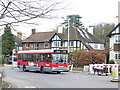
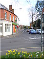
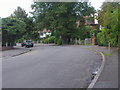
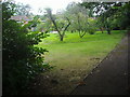
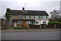
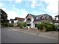
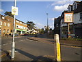
KT10 0NR is a compact residential postcode in England, home to 2,127 people spread across a densely populated area of 1.41 km². This small cluster of homes, predominantly houses, reflects a mature community with a median age of 47, where most residents fall within the 30–64 age range. The area’s high home ownership rate (85%) suggests a stable, long-term population, with few rental properties. Daily life here is characterised by proximity to essential services, including five railway stations within reach, such as Claygate and Esher, which link residents to London and surrounding towns. The postcode’s low crime risk (Safety Score: 78/100) and absence of environmental constraints like protected woodlands or flood zones make it an appealing choice for those prioritising safety and practicality. Living in KT10 0NR means navigating a tight-knit, low-density neighbourhood where convenience and security are balanced with the challenges of limited space. The area’s small size means every home is near amenities, but it also demands a focus on local connectivity and community ties.
- Area Type
- Postcode
- Area Size
- Not available
- Population
- 2127
- Population Density
- 1509 people/km²
KT10 0NR is a predominantly owner-occupied area, with 85% of homes owned by residents rather than rented. The housing stock consists almost entirely of houses, not flats, which is unusual for a small postcode. This suggests a focus on family homes and larger properties, possibly reflecting the area’s mature demographic. The compact size of the postcode means the housing market is limited to a small number of properties, likely concentrated in a single locality. Buyers should consider that the immediate surroundings may offer more options, but within KT10 0NR itself, the availability of homes is constrained. The high home ownership rate indicates a stable market, but the lack of rental properties means it may not be ideal for those seeking short-term accommodation. For buyers prioritising security and established living, the area’s housing profile offers a predictable, low-risk investment.
House Prices in KT10 0NR
No properties found in this postcode.
Energy Efficiency in KT10 0NR
Living in KT10 0NR offers access to a range of amenities within walking or short driving distance. Retailers like Co-op Claygate, Morrisons Daily, and Waitrose Little Waitrose provide everyday shopping needs, while ferry landings at Ditton Island and Hampton Court Pier offer leisure and transport options. The proximity to railway stations such as Esher and Hinchley Wood ensures easy access to London and surrounding areas, supporting both commuting and travel. The area’s compact size means residents can reach these services without long journeys, enhancing convenience. While the data does not specify parks or recreational spaces, the absence of environmental constraints like protected woodlands suggests open areas may be available. The combination of retail, transport, and water-based connectivity creates a lifestyle that balances practicality with accessibility, ideal for those prioritising ease of movement and local amenities.
Amenities
Schools
| Rank | School | Type | Entry gender | Ages |
|---|
Explore more schools in this area
Go to Schools tabDemographics
The population of KT10 0NR is 2,127, with a density of 1,509 people per km², reflecting a tightly packed residential area. The median age is 47, with the majority of residents aged 30–64, indicating a community of working-age adults and older homeowners. Home ownership is exceptionally high at 85%, suggesting a stable demographic with few renters. The area is predominantly occupied by houses, not flats, which aligns with the presence of a mature, established population. The predominant ethnic group is White, though specific diversity data is not provided. The age profile and ownership figures imply a community focused on long-term living rather than transient housing. With no data on deprivation, it is unclear how economic factors might influence quality of life, but the high home ownership rate and low crime risk suggest a relatively affluent and secure environment.
Household Size
Accommodation Type
Tenure
Ethnic Group
Religion
Household Composition
Age
Household Deprivation
NS-SEC
Explore more demographic insights in this area
Go to Demographics tabPlanning
Planning Constraints
- Flood RiskPremium
- Ramsar Wetland SitesPremium
- Area of Outstanding Natural BeautyPremium
- Protected Nature ReservePremium
- Protected WoodlandPremium