Area Overview for HP13 5RW
Photos of HP13 5RW
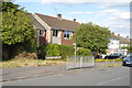
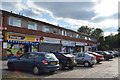
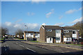
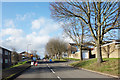
37 photos from this area
Area Information
Key information about the HP13 5RW including its size, population, and administrative classification.
- Area Type
- Postcode
- Area Size
- 1.5 hectares
- Population
- 1461
- Population Density
- 6022 people/km²
House Prices in HP13 5RW
46
Properties
£247,164
Average Sold Price
£134,950
Lowest Price
£345,000
Highest Price
Showing 46 properties
| Address | Type | Beds | Baths | Last Sale Price | Last Sale Date | |
|---|---|---|---|---|---|---|
| 119 The Pastures, High Wycombe, HP13 5RW | Terraced | 2 | 1 | £335,000 | Oct 2022 | |
| 75 The Pastures, High Wycombe, HP13 5RW | Terraced | 2 | 2 | £345,000 | Sep 2022 | |
| 81 The Pastures, High Wycombe, HP13 5RW | house | - | - | £300,000 | Feb 2022 | |
| 69 The Pastures, High Wycombe, HP13 5RW | Terraced | 2 | - | £300,000 | Oct 2021 | |
| 55 The Pastures, High Wycombe, HP13 5RW | Terraced | 3 | 1 | £304,000 | Jun 2021 | |
| 133 The Pastures, High Wycombe, HP13 5RW | Terraced | 2 | 1 | £280,000 | Mar 2021 | |
| 83 The Pastures, High Wycombe, HP13 5RW | Terraced | 2 | 1 | £288,000 | Jul 2020 | |
| 135 The Pastures, High Wycombe, HP13 5RW | house | 2 | 1 | £285,000 | Aug 2019 | |
| 107 The Pastures, High Wycombe, HP13 5RW | Terraced | 2 | 1 | £275,000 | Jul 2019 | |
| 117 The Pastures, High Wycombe, HP13 5RW | Terraced | 2 | 1 | £257,000 | Jun 2019 |
Page 1 of 5
Energy Efficiency in HP13 5RW
Amenities
Schools
| Rank | School | Type | Entry gender | Ages |
|---|
Explore more schools in this area
Go to Schools tabDemographics
Household Size
Family (3-5 people)
most common
Accommodation Type
Houses
most common
Tenure
63
majority
Ethnic Group
White
most common
Religion
N/A
most common
Household Composition
N/A
most common
Age
47
median
Adults (30-64 years)
most common
Household Deprivation
N/A
with no deprivation
NS-SEC
27
in Lower managerial occupations
Explore more demographic insights in this area
Go to Demographics tabPlanning
Planning Constraints
- Flood RiskPremium
- Ramsar Wetland SitesPremium
- Area of Outstanding Natural BeautyPremium
- Protected Nature ReservePremium
- Protected WoodlandPremium