Area Overview for HP11 2AY
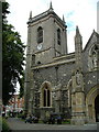
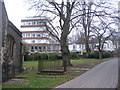
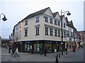
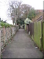
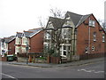
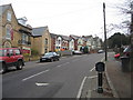
Photos of HP11 2AY


Area Information
HP11 2AY is a compact residential postcode in England, covering just 2,346 m² and home to 2,359 residents. Its high population density of 2,349 people per km² reflects a tightly knit community, where proximity to amenities and services is a defining feature. The area’s small size means it is likely a cluster of homes rather than a sprawling suburb, with a strong emphasis on local connectivity. Daily life here is shaped by its proximity to retail, transport, and educational hubs. The median age of 22 contrasts with the most common age range of 30-64 years, suggesting a mix of younger residents and families. While the area lacks large-scale infrastructure, its practical reach includes rail stations, supermarkets, and independent schools. For those seeking a balance between urban convenience and manageable size, HP11 2AY offers a focused living environment, though its limited space means every decision about where to live here carries weight.
- Area Type
- Postcode
- Area Size
- 2346 m²
- Population
- 2359
- Population Density
- 2349 people/km²
The property market in HP11 2AY is characterised by a low home ownership rate of 37%, suggesting that the area is more rental-focused than owner-occupied. The predominant accommodation type is flats, which is typical for high-density areas. This means the housing stock is likely to consist of smaller, managed properties rather than detached homes. Given the area’s small size, the immediate surroundings may offer limited property options, making location and proximity to amenities critical factors for buyers. The compact nature of HP11 2AY means that properties are likely to be in close proximity to retail, transport, and educational facilities, which could be a significant draw for those prioritising convenience. However, the limited space may also mean competition for available properties, particularly in sought-after areas near key services.
House Prices in HP11 2AY
No properties found in this postcode.
Energy Efficiency in HP11 2AY
The lifestyle in HP11 2AY is shaped by its proximity to a range of amenities within practical reach. Retail options include Iceland High, Tesco High, and M&S Eden, providing access to grocery and general shopping needs. The area’s rail network, with stations at High Wycombe, Bourne End, and Marlow, facilitates easy travel to nearby destinations. While specific parks or leisure facilities are not detailed in the data, the presence of retail and transport hubs suggests a focus on convenience over expansive recreational spaces. For residents, this means a daily life centred around local shopping, efficient commuting, and the ability to access broader regional services with minimal effort. The compact nature of the area ensures that amenities are never far, though it may lack the sprawling green spaces found in larger towns.
Amenities
Schools
The nearest school to HP11 2AY is Wycombe Abbey, an independent institution. While no Ofsted rating is provided, the presence of an independent school suggests that the area may attract families seeking private education. Independent schools often cater to specific academic or extracurricular preferences, which can be a deciding factor for some households. However, the data does not include state school options or their performance metrics, so families relying on public education may need to look further afield. The availability of a single notable school in the immediate vicinity highlights the importance of assessing broader educational options when considering HP11 2AY as a long-term residence.
| Rank | School | Type | Entry gender | Ages |
|---|
Explore more schools in this area
Go to Schools tabDemographics
The community in HP11 2AY is predominantly composed of adults aged 30-64 years, with a median age of 22 that may reflect a younger demographic skew, possibly due to student populations or transient residents. Home ownership is relatively low at 37%, indicating that the majority of residents are likely to be renters. The accommodation type is predominantly flats, which aligns with the area’s compact nature and higher density. The predominant ethnic group is White, though no specific diversity statistics are provided. The population density of 2,349 people per km² suggests a closely packed living environment, which can foster a sense of community but may also contribute to higher demand for shared resources. For buyers, this demographic profile implies a market where rental properties are more common, and the housing stock is tailored to smaller, shared living arrangements.
Household Size
Accommodation Type
Tenure
Ethnic Group
Religion
Household Composition
Age
Household Deprivation
NS-SEC
Explore more demographic insights in this area
Go to Demographics tabPlanning
Planning Constraints
- Flood RiskPremium
- Ramsar Wetland SitesPremium
- Area of Outstanding Natural BeautyPremium
- Protected Nature ReservePremium
- Protected WoodlandPremium