Area Overview for Bramshott and Liphook
Photos of Bramshott and Liphook


Area Information
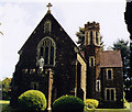
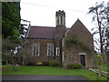
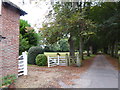
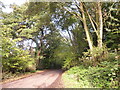
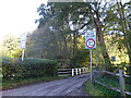
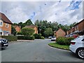
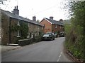
Bramshott and Liphook is a civil parish covering 26.1 square kilometres in East Hampshire, with a resident population of 3,940. The area combines the village of Bramshott with the larger settlement of Liphook, creating a neighbourhood that sits near the historical boundary of the Royal Forest of Woolmer. You are looking at a community with deep roots, first mentioned in the Domesday Book of 1086. The parish lies approximately one mile north of Liphook towards the borders of Surrey and Sussex. Life here is defined by proximity to Liphook, the nearest railway station located just 1 to 1.5 miles south on the London to Portsmouth line. Residents benefit from access to historic sites like Bramshott Manor, which is recognised as England's oldest continuously inhabited manor house, and the early 13th-century church of St Mary the Virgin. The landscape includes preserved sunken lanes maintained by the Bramshott and Liphook Heritage Society. With a population density of 151 people per square kilometre, the area feels settled and established rather than overcrowded. You are buying into an environment where medieval origins blend with modern domestic life. The neighbourhood offers a specific character shaped by its history, from the tax evasion scandals of the 16th century to its later integration with the railway network. Potential buyers seeking homes in Bramshott and Liphook find a location that balances rural charm with practical connectivity to Hampshire and beyond.
- Area Type
- Parish
- Area Size
- 26.1 km²
- Population
- 3940
- Population Density
- 151 people/km²
Demographics
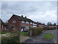
The community profile reveals a settled population with a median age of 70 years. This figure indicates you are looking at an area with a significant cohort of older residents. The most common age range data simply reflects the total population structure, confirming the demographic skew towards later life stages. You will encounter a neighbourhood where the average resident has likely lived here for decades. Home ownership stands at 83 per cent, a figure that makes this one of the most owner-occupied parishes in the country. This high rate suggests you are entering a market dominated by existing residents rather than transient tenants or first-time buyers entering for the first time. The household composition and accommodation type data cover the total area, reinforcing the stability of the local population base. Diversity metrics, predominant ethnic groups, and religious affiliations are marked as totals in the available breakdown, meaning specific granular statistics for these categories are not provided in the source data. However, with 83 per cent of homes occupied by owners, the community atmosphere is likely anchored by long-term families. You can expect a quiet, stable residential environment where neighbours have known each other for generations. This demographic reality shapes the pace of life and the social fabric of Bramshott and Liphook.
Household Size
Accommodation Type
Tenure
Ethnic Group
Religion
Household Composition
Age
Household Deprivation
NS-SEC
Explore more demographic insights in this area
Go to Demographics tabPlanning
Planning Constraints
- Flood RiskPremium
- Ramsar Wetland SitesPremium
- Protected Nature ReservePremium
- Protected WoodlandPremium