Area Overview for GU7 1AL
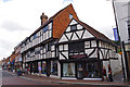
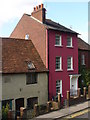
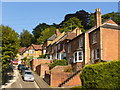
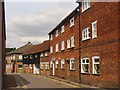
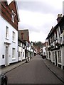
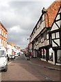
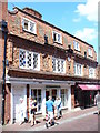
Photos of GU7 1AL


Area Information
GU7 1AL is a compact residential postcode in England, covering just 232 square metres and home to 2,270 residents. Its high population density of nearly 9.8 million people per square kilometre reflects its small, tightly knit character. This area is defined by its proximity to key amenities and transport links, making it a practical choice for those seeking convenience without sacrificing space. The community here skews older, with a median age of 47 and a majority of residents aged between 30 and 64. Most properties are owner-occupied, and the area is dominated by houses rather than flats, suggesting a focus on family living. Daily life is shaped by the availability of nearby schools, retail hubs, and rail stations, which provide easy access to Godalming and surrounding areas. While the population is relatively small, the area’s connectivity and amenities create a functional, if modest, urban environment. For buyers, GU7 1AL offers a blend of residential comfort and accessibility, though its limited size means the housing stock is finite.
- Area Type
- Postcode
- Area Size
- 232 m²
- Population
- 2270
- Population Density
- 2931 people/km²
GU7 1AL is predominantly an owner-occupied area, with 60% of properties owned by residents rather than rented. The accommodation type is largely houses, which is uncommon in densely populated urban areas. This mix suggests a focus on family homes, though the small size of the postcode means the housing stock is limited. Buyers should consider that the area’s compact nature may restrict availability, particularly for those seeking larger properties. The high home ownership rate indicates a stable market, but the lack of flats or apartments may limit options for renters or those prioritising investment properties. For those seeking a residential area with a strong sense of community, GU7 1AL’s housing stock offers a blend of traditional homes and proximity to amenities, though its size means the immediate surroundings are critical for additional choices.
House Prices in GU7 1AL
No properties found in this postcode.
Energy Efficiency in GU7 1AL
Daily life in GU7 1AL is shaped by its proximity to retail and transport hubs. The nearby shops, including Cook Godalming, Waitrose, and Sainsburys, offer a range of goods, from groceries to household essentials, reducing the need for long trips. Rail stations such as Godalming and Milford provide easy access to broader networks, supporting both work and leisure activities. While the data does not mention parks or leisure facilities, the area’s small size suggests that amenities are tightly clustered. The presence of multiple rail stations and retail options indicates a practical, if compact, lifestyle. For residents, this means a balance between convenience and limited space, with the need to plan for nearby areas to access more extensive services.
Amenities
Schools
Residents of GU7 1AL have access to a range of educational facilities, including The Wharf Nursery School, which provides early-years education, and Moss Lane School, a primary school with a good Ofsted rating. The presence of both nursery and primary schools within the area is a significant advantage for families, reducing the need for long commutes. Moss Lane’s good rating reflects its quality of education, which is reassuring for parents. However, no secondary schools are listed in the data, so families may need to look further afield for high school options. The mix of school types ensures that young children can be educated locally, though the absence of higher-tier institutions may influence decisions for those requiring a full range of educational services.
| Rank | School | Type | Entry gender | Ages |
|---|---|---|---|---|
| 1 | The Wharf Nursery School | nursery | N/A | N/A |
| 2 | Moss Lane School | primary | N/A | N/A |
Explore more schools in this area
Go to Schools tabDemographics
The population of GU7 1AL is 2,270, with a median age of 47, indicating a mature community. The most common age group is adults aged 30–64, reflecting a demographic skewed towards middle-aged individuals. Home ownership is high at 60%, with the majority of properties being houses rather than flats. This suggests a stable, long-term resident base. The predominant ethnic group is White, though no specific data on diversity or deprivation is provided. The area’s population density of nearly 9.8 million people per square kilometre is exceptionally high, which may influence the pace of life and proximity of services. For residents, this density means amenities are within walking distance but could also imply limited green space. The age profile and ownership rates suggest a community focused on established living, with fewer young families or transient populations.
Household Size
Accommodation Type
Tenure
Ethnic Group
Religion
Household Composition
Age
Household Deprivation
NS-SEC
Explore more demographic insights in this area
Go to Demographics tabPlanning
Planning Constraints
- Flood RiskPremium
- Ramsar Wetland SitesPremium
- Area of Outstanding Natural BeautyPremium
- Protected Nature ReservePremium
- Protected WoodlandPremium
- Crime RiskPremium