Area Overview for GU31 5YE
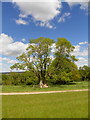
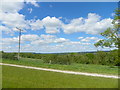
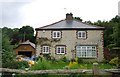
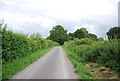
Photos of GU31 5YE
Area Information
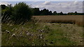
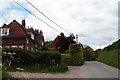
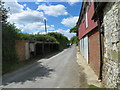
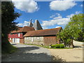
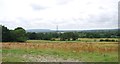
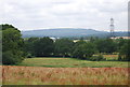
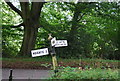
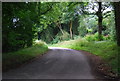
Living in GU31 5YE offers a quiet, low-density residential experience in a small cluster of homes. With a population of 2,053 and a density of 37 people per square kilometre, the area feels uncluttered and community-focused. The demographic profile suggests a settled population, with a median age of 47 and the majority of residents aged between 30 and 64. This suggests a mature, stable community where most homes are owner-occupied—71% of households own their properties. The area’s compact size means daily life is manageable without the congestion of larger towns, while nearby amenities and transport links provide access to broader services. For those seeking a peaceful, family-oriented environment with minimal urban pressure, GU31 5YE balances seclusion with practical connectivity. Its proximity to Petersfield and Liss railway stations, combined with modest broadband and mobile coverage, ensures residents can stay connected without sacrificing tranquillity. The area’s character is defined by its simplicity: a place where neighbours are familiar, and the pace of life remains unhurried.
- Area Type
- Postcode
- Area Size
- Not available
- Population
- 2053
- Population Density
- 37 people/km²
The property market in GU31 5YE is characterised by a high rate of home ownership—71% of households own their homes—suggesting a strong preference for long-term residency over rental living. The accommodation type is predominantly houses, which aligns with the area’s low density and suburban layout. This means the housing stock is unlikely to include high-rise blocks or purpose-built apartments, offering instead a mix of detached or semi-detached homes. As a small area with limited expansion potential, the market is likely to be stable but not highly dynamic. Buyers should consider the proximity to nearby towns for additional property options, though GU31 5YE itself provides a quiet, owner-occupied environment. The high home ownership rate also implies lower turnover, meaning properties may be held for longer periods, which can be advantageous for those seeking a stable investment.
House Prices in GU31 5YE
No properties found in this postcode.
Energy Efficiency in GU31 5YE
The lifestyle in GU31 5YE is shaped by its proximity to retail and transport hubs. Nearby shops include The Southern Co-operative Co, Asda Ramshill, and M&S Petersfield SF, offering a range of shopping options within practical reach. These retail outlets provide access to everyday essentials, reducing the need for long trips to larger centres. The area’s rail links to Petersfield and Liss stations add convenience, allowing residents to travel easily to nearby towns for additional amenities, dining, or leisure activities. While the data does not specify parks or recreational facilities, the low population density suggests ample space for outdoor activities. The combination of local retail, rail access, and a quiet residential setting creates a lifestyle that prioritises convenience without sacrificing the peace of a smaller community.
Amenities
Schools
The nearest school to GU31 5YE is Harting CofE Primary School, which serves the local community with a good Ofsted rating. This school is a primary institution, catering to younger children, though no secondary schools are listed in the data. The presence of a primary school with a good rating indicates that families in the area have access to a reputable early education option. However, parents seeking secondary schooling may need to look further afield, potentially to Petersfield or Liss. The absence of secondary schools nearby means that the area’s educational provision is focused on younger children, which could be a consideration for families with older children. Overall, the school infrastructure supports the needs of primary-age students but may require additional planning for secondary education.
| Rank | School | Type | Entry gender | Ages |
|---|
Explore more schools in this area
Go to Schools tabDemographics
The community in GU31 5YE is predominantly composed of adults aged 30 to 64, reflecting a mature demographic with a median age of 47. This suggests a population that is largely established in careers and family life, with fewer young dependents or retirees compared to other areas. Home ownership is high, at 71%, indicating a preference for long-term residency over rental properties. The accommodation type is primarily houses, which aligns with the area’s low density and suburban feel. The predominant ethnic group is White, with no specific data on other groups provided. The population density of 37 people per square kilometre ensures a spread-out, less crowded environment. This profile implies a community that values stability and privacy, with limited pressure from overcrowding or transient populations. For buyers, this suggests a neighbourhood where properties are likely to retain value and where local services cater to a consistent demographic.
Household Size
Accommodation Type
Tenure
Ethnic Group
Religion
Household Composition
Age
Household Deprivation
NS-SEC
Explore more demographic insights in this area
Go to Demographics tabPlanning
Planning Constraints
- Flood RiskPremium
- Ramsar Wetland SitesPremium
- Area of Outstanding Natural BeautyPremium
- Protected Nature ReservePremium
- Protected WoodlandPremium