Area Overview for GU29 0JZ
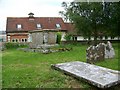
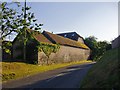
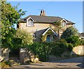
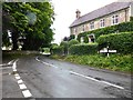
Photos of GU29 0JZ


Area Information
GU29 0JZ is a small, compact residential cluster in England, spanning just 1.5 hectares and home to 2053 people. With a population density of 37 people per square kilometre, it’s a low-density area where neighbours are likely to know one another. The community here is predominantly made up of adults aged 30 to 64, reflecting a mature, stable demographic. Daily life in GU29 0JZ balances quiet living with practical access to nearby amenities. The area’s small size means residents can walk or cycle to local shops, schools, and transport links without long commutes. While it lacks the bustle of larger towns, its proximity to Petersfield and Liss railway stations offers connections to broader networks. The low crime risk score of 86/100 and absence of environmental constraints like protected woodlands or flood zones make it an attractive option for those seeking safety and simplicity. For buyers, GU29 0JZ offers a snapshot of English rural living, with a focus on home ownership and family-friendly infrastructure.
- Area Type
- Postcode
- Area Size
- 1.5 hectares
- Population
- 2053
- Population Density
- 37 people/km²
GU29 0JZ is primarily an owner-occupied area, with 71% of residents living in homes they own. The housing stock consists mainly of houses, which is typical for a low-density, suburban postcode. This makes the area more suited to families or individuals seeking private, spacious properties rather than a rental market. The small size of the area—just 1.5 hectares—means the housing stock is limited, and buyers should consider nearby postcodes for more options. The focus on houses suggests a preference for traditional, detached or semi-detached properties, which may appeal to those valuing privacy and space. For buyers, the area’s compact nature means proximity to amenities is a key advantage, though the limited number of properties could make competition for available homes more intense.
House Prices in GU29 0JZ
Showing 7 properties
| Address | Type | Beds | Baths | Last Sale Price | Last Sale Date | |
|---|---|---|---|---|---|---|
| Heatherbank, 1 Orchard Close, Elsted, GU29 0JZ | Detached | - | - | £475,000 | Feb 2008 | |
| 3 Orchard Close, Elsted, GU29 0JZ | Detached | - | - | £345,000 | May 2000 | |
| Brunanburgh, 4 Orchard Close, Elsted, GU29 0JZ | Bungalow | 2 | 1 | £139,000 | Dec 1997 | |
| 2 Orchard Close, Elsted, GU29 0JZ | Bungalow | 3 | - | £186,000 | Jun 1997 | |
| Barncroft, Orchard Close, Elsted, GU29 0JZ | Detached | - | - | £380,000 | Nov 1995 | |
| Slate Cottage, Orchard Close, Elsted, GU29 0JZ | Detached | - | - | £170,000 | Jul 1995 | |
| Wydon, Orchard Close, Elsted, GU29 0JZ | Detached | - | - | - | - |
Energy Efficiency in GU29 0JZ
Living in GU29 0JZ offers access to essential amenities within walking or cycling distance. The area has five retail venues, including Sainsburys Midhurst, The Southern Co-operative Co, and Spar, providing convenience for grocery shopping and daily needs. Nearby railway stations at Petersfield and Liss add to the area’s connectivity, enabling easy travel to larger towns for additional services. While there are no parks or leisure facilities explicitly listed, the low population density and absence of environmental constraints suggest open spaces may be available nearby. The compact nature of the area means residents can enjoy a mix of local retail and transport options without long commutes. This balance of practicality and accessibility makes GU29 0JZ suitable for those prioritising convenience and a quiet lifestyle.
Amenities
Schools
The nearest school to GU29 0JZ is Harting CofE Primary School, which serves the local community with a good Ofsted rating. This school caters to primary education, making it a critical resource for families with young children. However, the absence of secondary schools in the immediate area means parents may need to look further afield for secondary education. The presence of a well-rated primary school is a strong point for the area, offering a solid foundation for early education. For families prioritising school quality, this is a positive factor, though the lack of local secondary options could be a consideration. The school’s rating reflects its effectiveness in teaching and student outcomes, which is reassuring for parents seeking reliable education for their children.
| Rank | School | Type | Entry gender | Ages |
|---|
Explore more schools in this area
Go to Schools tabDemographics
The population of GU29 0JZ skews towards adults aged 30 to 64, with a median age of 47. This suggests a community of established professionals, families, and retirees, rather than a younger, transient population. Home ownership is high at 71%, indicating a stable, long-term resident base. The predominant accommodation type is houses, which aligns with the area’s low density and suburban character. The majority of residents identify as White, though no specific data on other ethnic groups is provided. With a population of 2053, the area is small enough to foster a close-knit community but large enough to support essential services. The absence of detailed deprivation data means it’s unclear whether economic challenges exist, but the high home ownership rate and low crime risk suggest a relatively secure quality of life.
Household Size
Accommodation Type
Tenure
Ethnic Group
Religion
Household Composition
Age
Household Deprivation
NS-SEC
Explore more demographic insights in this area
Go to Demographics tabPlanning
Planning Constraints
- Flood RiskPremium
- Ramsar Wetland SitesPremium
- Area of Outstanding Natural BeautyPremium
- Protected Nature ReservePremium
- Protected WoodlandPremium