Area Overview for GU26 6NH
Photos of GU26 6NH


Area Information
Living in GU26 6NH offers a compact, tightly knit residential experience within a small cluster of 1.3 hectares. With a population of 1,357, the area is densely populated, reflecting a community that prioritises proximity to amenities and services. The median age of 47 suggests a stable, mature demographic, with adults aged 30–64 forming the majority. This is a predominantly owner-occupied area, with 66% of homes owned by residents, and the accommodation is largely houses rather than flats. The high population density of 104,846 people per square kilometre underscores the area’s efficient use of space. Daily life here is shaped by proximity to key services, including nearby schools, rail links, and retail outlets. The low flood risk and absence of environmental constraints like AONB or protected woodlands make it a practical choice for families and professionals seeking a balance between urban convenience and safety.
- Area Type
- Postcode
- Area Size
- 1.3 hectares
- Population
- 1357
- Population Density
- 1796 people/km²
The property market in GU26 6NH is characterised by a high rate of home ownership (66%), suggesting a community of long-term residents rather than a transient rental market. The accommodation is predominantly houses, which may appeal to families seeking space and privacy. Given the area’s small size and high population density, the housing stock is limited, making it a niche market for buyers. The proximity to rail stations and amenities like Sainsburys and Co-op adds to the area’s appeal, though the compact nature of the postcode means buyers must consider the immediate surroundings for additional options. This is not a high-end or luxury market but a practical, family-oriented area with clear advantages in connectivity and safety.
House Prices in GU26 6NH
Showing 11 properties
| Address | Type | Beds | Baths | Last Sale Price | Last Sale Date | |
|---|---|---|---|---|---|---|
| 3 Vicarage Gardens, Grayshott, Hindhead, GU26 6NH | house | - | - | £795,000 | Feb 2024 | |
| 2 Vicarage Gardens, Grayshott, Hindhead, GU26 6NH | house | 4 | - | £735,000 | Mar 2021 | |
| 7 Vicarage Gardens, Grayshott, Hindhead, GU26 6NH | Bungalow | - | - | £690,000 | Jul 2020 | |
| 8 Vicarage Gardens, Grayshott, Hindhead, GU26 6NH | Detached | 4 | 2 | £680,000 | May 2019 | |
| 5 Vicarage Gardens, Grayshott, Hindhead, GU26 6NH | Bungalow | - | - | £525,000 | Jun 2016 | |
| 1 Vicarage Gardens, Grayshott, Hindhead, GU26 6NH | Detached | 5 | 3 | £660,000 | Feb 2015 | |
| 9 Vicarage Gardens, Grayshott, Hindhead, GU26 6NH | Detached | - | - | £275,000 | Jun 2001 | |
| Packwood, 4 Vicarage Gardens, Grayshott, Hindhead, GU26 6NH | Detached | 5 | - | - | - | |
| The Vicarage, 10 Vicarage Gardens, Grayshott, Hindhead, GU26 6NH | house | - | - | - | - | |
| Sunnyside, 6 Vicarage Gardens, Grayshott, Hindhead, GU26 6NH | Bungalow | - | - | - | - |
Energy Efficiency in GU26 6NH
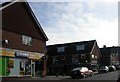
The lifestyle in GU26 6NH is shaped by its proximity to retail and transport hubs. Within practical reach are five retail outlets, including Sainsburys Grayshott, Co-op Grayshott, and M&S Hindhead BP, offering everyday shopping and fueling needs. Three rail stations provide access to nearby towns and cities, enhancing mobility. While the area lacks large-scale leisure facilities, the compact layout ensures amenities are within walking or short driving distance. This combination of retail convenience and transport links supports a practical, community-focused lifestyle.
Amenities
Schools
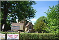
The nearest school to GU26 6NH is Grayshott Church of England Controlled Primary School, a primary school with an Ofsted rating of satisfactory. This provides families with a local option for early education, though secondary schooling would require commuting to nearby towns. The presence of a primary school supports the area’s appeal to families with young children, offering a foundation for education within walking distance. The absence of secondary schools in the immediate vicinity is a practical consideration for parents planning long-term in the area.
| Rank | School | Type | Entry gender | Ages |
|---|
Explore more schools in this area
Go to Schools tabDemographics
The community in GU26 6NH is predominantly composed of adults aged 30–64, with a median age of 47. This suggests a population skewed towards middle-aged individuals, likely with established careers and families. Home ownership is high, at 66%, indicating a stable housing market where most residents are long-term residents. The accommodation type is primarily houses, which aligns with the demographic’s preference for family homes. The predominant ethnic group is White, though no specific data on diversity or deprivation levels is provided. The high population density—104,846 people per square kilometre—suggests a tightly packed residential area, which may influence the character of local interactions and the availability of shared spaces.
Household Size
Accommodation Type
Tenure
Ethnic Group
Religion
Household Composition
Age
Household Deprivation
NS-SEC
Explore more demographic insights in this area
Go to Demographics tabPlanning
Planning Constraints
- Flood RiskPremium
- Ramsar Wetland SitesPremium
- Area of Outstanding Natural BeautyPremium
- Protected Nature ReservePremium
- Protected WoodlandPremium