Area Overview for GU17 7YQ
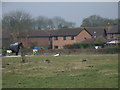
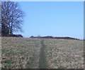
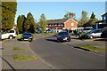
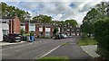
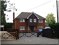
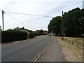
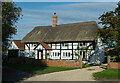
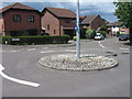
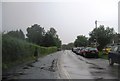
Photos of GU17 7YQ


Area Information
Living in GU17 7YQ means being part of a compact, residential cluster in England with a population of 1470 people spread across a densely populated area of 688 people per square kilometre. This small postcode area is characterised by its focus on homeownership, with 95% of properties occupied by their owners. The community is predominantly composed of adults aged 30–64, suggesting a stable, family-oriented demographic. Daily life here is shaped by proximity to essential services, including five retail outlets such as Waitrose Yateley and Sainsburys Yateley, and five nearby railway stations like Sandhurst and Crowthorne. The area’s low crime risk and absence of environmental constraints such as protected woodlands or wetlands make it a practical choice for those seeking a balance between convenience and safety. With broadband scores of 86 and mobile coverage of 74, residents have reliable digital connectivity, supporting both work and leisure. The mix of primary and special schools, including Newlands Primary School with a ‘good’ Ofsted rating, ensures educational options for families. GU17 7YQ is a small but functional area, ideal for those prioritising security, accessibility, and a tight-knit community.
- Area Type
- Postcode
- Area Size
- Not available
- Population
- 1470
- Population Density
- 688 people/km²
The property market in GU17 7YQ is dominated by owner-occupied homes, with 95% of properties in private hands. This high level of homeownership indicates a community that values long-term residency and investment, rather than a rental market. The accommodation type is primarily houses, which is typical of areas with lower population density and a focus on family living. As a small postcode area, the housing stock is limited in scale, meaning buyers should consider the immediate surroundings for more options. The absence of high-density housing or flats suggests a preference for single-family homes, which may appeal to those seeking space and privacy. For buyers, this area offers a stable market with minimal turnover, but the small size of the postcode means competition could be fierce. Proximity to rail stations and retail hubs like Waitrose Yateley adds to the area’s practicality, making it a viable choice for those prioritising security, convenience, and a settled lifestyle.
House Prices in GU17 7YQ
No properties found in this postcode.
Energy Efficiency in GU17 7YQ
Residents of GU17 7YQ have access to a range of amenities within practical reach, enhancing daily life. The area is served by five retail outlets, including major supermarkets like Waitrose Yateley, Sainsburys Yateley, and Asda Yateley, ensuring convenience for shopping and groceries. Nearby rail stations such as Sandhurst, Crowthorne, and Blackwater provide easy access to regional transport, while two airports—Blackbushe and Farnborough—offer additional travel options. The presence of these amenities supports a lifestyle that balances convenience with accessibility. The compact nature of the area means that essential services are close, reducing the need for long commutes. The mix of retail, transport, and travel infrastructure creates a practical environment for both daily errands and broader mobility. While the area lacks large parks or leisure facilities, its proximity to rail and retail hubs compensates with functionality, making it suitable for those prioritising efficiency over expansive recreational spaces.
Amenities
Schools
GU17 7YQ is served by two schools: Newlands Primary School, which holds a ‘good’ Ofsted rating, and Hurst Lodge School, a special school. The presence of both a primary school and a special school indicates a range of educational provision for families with children of different needs. Newlands Primary School’s ‘good’ rating suggests a satisfactory standard of education, with effective teaching and outcomes for students. Hurst Lodge School caters to students with special educational needs, providing tailored support. Together, these institutions offer parents a choice between mainstream and specialist education. The proximity of these schools to the area means families can access both options without long commutes. The combination of school types reflects a community that values inclusivity and diverse educational pathways, ensuring that children with varying requirements can receive appropriate support.
| Rank | School | Type | Entry gender | Ages |
|---|
Explore more schools in this area
Go to Schools tabDemographics
The community in GU17 7YQ is predominantly composed of adults aged 30–64, with a median age of 47. This suggests a population that is largely established, with a focus on long-term residency. Homeownership is exceptionally high at 95%, indicating a stable, owner-occupied area where most residents live in their own homes rather than renting. The accommodation type is primarily houses, which aligns with the higher home ownership rate and the absence of high-density housing. The predominant ethnic group is White, with no data provided on other ethnicities. The age profile and homeownership levels suggest a community that is family-oriented and less transient. The low population density of 688 people per square kilometre, combined with the high home ownership, implies a mix of larger properties and a quieter, more private lifestyle. This demographic profile supports a neighbourhood where stability and long-term investment are prioritised, with fewer pressures from rental markets or transient populations.
Household Size
Accommodation Type
Tenure
Ethnic Group
Religion
Household Composition
Age
Household Deprivation
NS-SEC
Explore more demographic insights in this area
Go to Demographics tabPlanning
Planning Constraints
- Flood RiskPremium
- Ramsar Wetland SitesPremium
- Area of Outstanding Natural BeautyPremium
- Protected Nature ReservePremium
- Protected WoodlandPremium