Area Overview for GU16 6GS
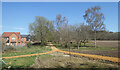
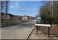
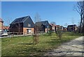
Photos of GU16 6GS


Area Information
GU16 6GS is a small, tightly defined postcode area in England, encompassing just 1.2 hectares and home to 2,494 residents. Its compact size means the community is close-knit, with a population density of 424 people per square kilometre. This area is characterised by its residential focus, with a mix of homes that cater to a predominantly middle-aged demographic. Daily life here is shaped by proximity to essential services, including multiple retail outlets and rail links, which connect residents to nearby towns. The area’s modest scale ensures a sense of familiarity, though it remains within reach of larger urban centres. For those seeking a balance between quiet living and practical connectivity, GU16 6GS offers a straightforward proposition: a small, manageable community with clear access to amenities and transport. The presence of schools, from primary to independent institutions, suggests it is a family-friendly location. However, its limited size means the area is best suited for those prioritising convenience over expansive space.
- Area Type
- Postcode
- Area Size
- 1.2 hectares
- Population
- 2494
- Population Density
- 424 people/km²
The property market in GU16 6GS is dominated by owner-occupied homes, with 60% of residents living in properties they own. This contrasts with rental markets, where private tenants are more prevalent. The area’s accommodation type is largely houses, which suggests a preference for detached or semi-detached properties over flats or apartments. Given the postcode’s small size, the housing stock is likely limited in volume, meaning the market is not saturated with new developments. For buyers, this implies a focus on existing homes rather than speculative investment. The high proportion of owner-occupiers may indicate a community with long-term residency, which can stabilise property values. However, the limited area size means buyers should consider the immediate surroundings for additional options. The market is unlikely to cater to those seeking large, modern developments, instead offering a more traditional, compact housing landscape.
House Prices in GU16 6GS
Showing 6 properties
Energy Efficiency in GU16 6GS
The lifestyle in GU16 6GS is shaped by its proximity to essential amenities. Retail options include Spar and Tesco Frimley, providing access to everyday shopping needs within walking or short driving distance. The area’s rail network, with stations such as Farnborough North and Frimley, ensures residents can reach nearby towns and services quickly. Farnborough Airport adds another layer of convenience for those requiring air travel. While the data does not specify parks or leisure facilities, the presence of multiple retail and transport hubs suggests a practical, service-oriented lifestyle. The mix of shops, rail links, and airport access means daily errands and travel are efficiently managed, reducing the need for long commutes. For families, the availability of schools and retail options within the area supports a self-contained, community-focused way of life.
Amenities
Schools
GU16 6GS is served by three distinct schools, each catering to different educational needs. Blackdown Primary School provides foundational education for younger children, while Cheswycks School is an independent institution, likely offering specialist or fee-based education. Portesbery School, a special school, supports students with specific learning requirements. This mix of school types ensures families have options, whether they seek state education, independent schooling, or specialist support. The presence of a special school highlights the area’s commitment to inclusive education, though it may also mean the local catchment area is carefully managed to meet regulatory standards. For parents, the availability of multiple school types reduces the need to relocate for education, a key consideration for families prioritising convenience. However, the exact Ofsted ratings for these schools are not specified in the data, so further research would be needed to assess their performance.
| Rank | School | Type | Entry gender | Ages |
|---|
Explore more schools in this area
Go to Schools tabDemographics
The population of GU16 6GS skews towards adults aged 30–64, with a median age of 47. This suggests a community with a strong presence of working-age individuals and families, rather than a younger or retired demographic. Home ownership is relatively high at 60%, indicating a stable housing market where many residents are long-term occupants. The area is dominated by houses rather than flats, aligning with the preferences of those who prioritise private, standalone living. The predominant ethnic group is White, though the data does not specify further diversity metrics. With no information on deprivation levels, it is unclear how this affects access to services or quality of life. However, the age profile and home ownership rate imply a community that is economically stable, with a focus on established households rather than transient populations.
Household Size
Accommodation Type
Tenure
Ethnic Group
Religion
Household Composition
Age
Household Deprivation
NS-SEC
Explore more demographic insights in this area
Go to Demographics tabPlanning
Planning Constraints
- Flood RiskPremium
- Ramsar Wetland SitesPremium
- Area of Outstanding Natural BeautyPremium
- Protected Nature ReservePremium
- Protected WoodlandPremium