Area Overview for Forstal
Photos of Forstal


Area Information
Forstal is a compact built-up area in England, spanning 60.9 hectares. It is a place where older residents predominate, with a median age of 70, suggesting a community shaped by long-term settlement. The area’s size is modest, making it a tight-knit neighbourhood where daily life revolves around local amenities and familiar faces. Forstal is not a sprawling suburb but a defined urban space, with homes and services clustered closely. Its character is defined by practicality and proximity—residents can access shops, transport, and leisure options within practical reach. While the area does not cater to young families or commuters in the same way as larger towns, it offers a quiet, stable environment for those prioritising convenience over expansion. Forstal’s appeal lies in its simplicity: no sprawling estates or complex infrastructure, just a straightforward, low-maintenance way of living. It is an area where home ownership is common, with 65% of properties owned by residents, reflecting a community rooted in place. For those seeking a retirement-focused or low-traffic environment, Forstal provides a baseline of accessibility without the pressures of urban density.
- Area Type
- Built Up Area 250
- Area Size
- 60.9 hectares
- Population
- Not available
- Population Density
- Not available
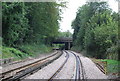
Living in Forstal means access to a selection of retail and transport hubs within walking or short driving distance. The area is served by five retail outlets, including Sainsburys Larkfield, Aldi Aylesford, and Waitrose Allington, providing a mix of grocery and everyday shopping options. These stores cater to the needs of a local population, though the absence of larger supermarkets or specialist shops may require trips to nearby towns for more varied choices. Transport is well-served by five railway stations, offering links to surrounding areas via Aylesford, Barming, and New Hythe stations. Rochester Airport is also within reach, though its role in daily life depends on individual travel patterns. The presence of these amenities ensures that Forstal residents can manage routine errands and travel without excessive reliance on cars. The area’s lifestyle is defined by convenience rather than diversity—what is available is practical but limited in scope. For those prioritising ease of access over a wide range of leisure options, Forstal provides a straightforward, no-frills approach to daily living.
Amenities
Schools
| Rank | A + A* % | School | Type | Entry gender | Ages |
|---|
Explore more schools in this area
Go to Schools tabDemographics
The population of Forstal is predominantly older, with a median age of 70, indicating a community where retirement is the norm rather than the exception. This age profile suggests a demographic skewed towards those no longer in the workforce, which influences the area’s character and needs. Home ownership is strong, with 65% of residents owning their homes, pointing to a stable, long-term population rather than a transient one. The data does not specify household composition, accommodation types, or ethnic diversity, but the figures provided confirm that the area is not a melting pot of different backgrounds or family structures. The lack of detailed breakdowns means the community’s social fabric remains opaque, but the high home ownership rate implies a sense of permanence. Forstal is not a place of high turnover or youthful energy, but a steady, predictable environment. Residents here likely value security and familiarity over novelty, with their needs shaped by an older demographic. This profile is not without challenges—services and amenities must cater to an ageing population, which may influence local priorities and infrastructure.
Household Size
Accommodation Type
Tenure
Ethnic Group
Religion
Household Composition
Age
Household Deprivation
NS-SEC
Explore more demographic insights in this area
Go to Demographics tabPlanning
Planning Constraints
- Crime RiskLocked