Area Overview for Fawkham and West Kingsdown Ward
Photos of Fawkham and West Kingsdown Ward


Area Information
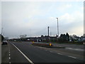
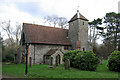
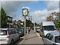
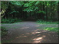
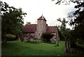
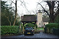
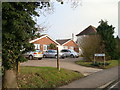
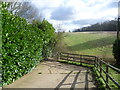
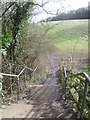
Fawkham and West Kingsdown Ward occupies 22.6 km² of south-eastern Kent and holds a modest population of 1,437 residents. This ward functions as a commuter village primarily for the Sevenoaks District, situated approximately 5 miles southeast of Swanley and 5.5 miles northeast of Sevenoaks. The area balances rural character with significant historical depth, sitting within the former Dartford Rural District area. Parishes define the local boundaries, extending near Farningham, Horton Kirby, South Darenth, and Ash-cum-Ridley. Living here means relying on the A20, the major London-Dover road now upgraded to a dual carriageway. You will find the village expanded mainly northeast of this artery, with additional rural housing pockets in Knatts Valley and East Hill to the southwest. Fawkham sits entirely within the Green Belt, remaining a hamlet, while West Kingsdown grew from a farming community into a residential area following the First World War. The geography includes the north side of the Brands Hatch motor racing circuit, which began its life on local farmland in the 1920s. A Grade II listed smock mill stands off Pells Lane, and the parish church of St Edmund King and Martyr reflects possible Saxon origins. Because the location is roughly 22.5 miles from central London, property values remain anchored by proximity to the capital rather than local industrial utility. The ward coordinates approximately 51.3498°N, 0.2643°E mark this distinct electoral division within Kent.
- Area Type
- District Borough Unitary Ward
- Area Size
- 22.6 km²
- Population
- 1437
- Population Density
- 64 people/km²
Demographics
The community within Fawkham and West Kingsdown Ward presents a distinctly mature profile with a median age of 70. This data point signals a very senior demographic compared to national averages, reflecting the area's status as a retired or semi-retired location. The population was recorded at 6,062 within the West Kingsdown parish alone during the 2011 census, though the current ward total stands lower at 1,437 people. Home ownership defines the housing tenure, with 85 per cent of residents owning their properties outright or via mortgage. This high rate suggests the local market attracts buyers who intend to stay for the long term rather than short-term investors or transient renters. Household composition statistics are aggregated in the provided data, indicating a focus on total figures rather than specific family breakdowns. Ethnic and religious demographics are listed as total aggregates in the current dataset. While specific breakdowns are not itemised, the uniformity of high home ownership and advanced age points toward a settled, established populace. The area does not yet show data for predominant ethnic groups or specific religious affiliations in the public summary provided. Consequently, the demographic picture remains centred on age and tenure, highlighting a stable environment where long-term residents have established roots over decades.
Household Size
Accommodation Type
Tenure
Ethnic Group
Religion
Household Composition
Age
Household Deprivation
NS-SEC
Explore more demographic insights in this area
Go to Demographics tabPlanning
Planning Constraints
- Flood RiskPremium
- Ramsar Wetland SitesPremium
- Area of Outstanding Natural BeautyPremium
- Protected Nature ReservePremium
- Protected WoodlandPremium
- Crime RiskPremium