Area Overview for Mayfield and Five Ashes
Photos of Mayfield and Five Ashes

Area Information
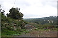
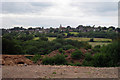
Living in Mayfield and Five Ashes offers a quiet residential experience within a defined administrative area. The district forms part of the Eridge wards within the Borough of East Sussex and covers a substantial 42.4 km². Despite this size, the population stands at 1,226 people, creating a sparse environment compared to surrounding regions. You will find a population density of 497 people per km², which suggests wide spaces and fewer crowds. This low density characterises daily life, prioritising calm over hustle and bustle. The area functions as a peaceful retreat rather than a densely packed urban hub. Prospective buyers looking for homes in Mayfield and Five Ashes should expect a setting where open space dominates the landscape. The layout supports a slower pace, making it suitable for those who value tranquillity. The administrative structure as a district borough unitary ward indicates clear local governance. You can rely on established boundaries for planning and community management. This area does not suffer from overcrowding, allowing residents ample room for gardens and outdoor activities. The distinctiveness lies in its modest population spread across a large physical footprint. Daily routines involve navigating a landscape designed for residents who prefer seclusion.
- Area Type
- Parish
- Area Size
- 42.4 km²
- Population
- 1226
- Population Density
- 497 people/km²
Demographics
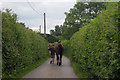
The community in Mayfield and Five Ashes reflects a mature population profile. The median age is 70, indicating that the residents are predominantly older adults. This age distribution shapes the social rhythm and service requirements of the neighbourhood. Most households likely consist of individuals or couples rather than young families with school-age children. Home ownership represents a core feature of this community, with 78% of properties owned outright or with a mortgage. This high rate of ownership suggests social stability and long-term residency. The low proportion of renter households reinforces the idea that families here build roots rather than viewing the area as temporary. You will find limited transient populations, contributing to a consistent local dynamic. The demographic data does not specify ethnicity or religion breakdowns, but the age focus remains clear. A median age of 70 means local amenities cater primarily to seniors. Social networks are likely formed through longevity and shared generations. When considering the community feel in Mayfield and Five Ashes, expect a neighbourhood governed by older demographics. This profile influences everything from council representation to local shop stock. The high ownership rate of 78% further cements the character of a settled, older population.
Household Size
Accommodation Type
Tenure
Ethnic Group
Religion
Household Composition
Age
Household Deprivation
NS-SEC
Explore more demographic insights in this area
Go to Demographics tabPlanning
Planning Constraints
- Flood RiskPremium
- Ramsar Wetland SitesPremium
- Area of Outstanding Natural BeautyPremium
- Protected Nature ReservePremium
- Protected WoodlandPremium