Area Overview for DA4 0AF
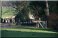
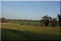
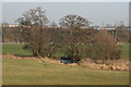
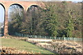
Photos of DA4 0AF


Area Information
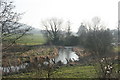
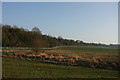
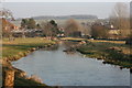
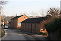
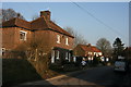
Living in DA4 0AF means being part of a small, tightly knit residential cluster in the heart of Eynsford, a village with a rich historical legacy. With a population of 1,864 and a density of 128 people per square kilometre, this area balances rural charm with practical living. The village is defined by its conservation status, preserving its architectural and historical significance. Centred around a ford through the river, Eynsford’s name reflects its origins as a river-meadow or river-ford settlement. Daily life here is shaped by its proximity to heritage sites like Eynsford Castle, a Scheduled Ancient Monument, and the Church of St Martin, a Grade I listed building. Residents benefit from a mix of historic and modern amenities, including nearby rail links and retail hubs. The area’s low crime risk and minimal environmental constraints make it appealing for families seeking a stable, community-focused environment.
- Area Type
- Postcode
- Area Size
- Not available
- Population
- 1864
- Population Density
- 128 people/km²
DA4 0AF is primarily an owner-occupied area, with 80% of homes owned by residents rather than rented. The accommodation type is predominantly houses, which aligns with the area’s rural character and conservation status. This suggests a focus on family homes and larger properties, as opposed to high-density housing. The small population and limited land area mean the housing stock is finite, with little scope for new developments. Buyers should expect a market where properties are likely to be long-term holdings, reflecting the age profile of the population. The lack of flats or apartments indicates that rental opportunities are limited, making this area more suitable for those seeking a permanent residence rather than short-term investment.
House Prices in DA4 0AF
No properties found in this postcode.
Energy Efficiency in DA4 0AF
Residents of DA4 0AF have access to essential amenities within practical reach, including five retail outlets such as Asda Swanley, Morrisons Daily West Kingsdown 28, and Co-op West. These stores provide everyday shopping needs, from groceries to household goods. The area’s proximity to rail stations enhances mobility, allowing easy access to nearby towns and services. While specific dining or leisure venues are not listed, the presence of retail hubs and rail connectivity suggests a lifestyle that prioritises convenience and accessibility. The village’s historic character, combined with modern amenities, creates a balanced environment where residents can enjoy both cultural heritage and practical living.
Amenities
Schools
The nearest school to DA4 0AF is The Anthony Roper Primary School, a primary institution with a good Ofsted rating. This school serves the local community, providing education for younger children in a setting that aligns with the area’s emphasis on stability and historical continuity. While no secondary schools are listed, the presence of a well-rated primary school is a key factor for families considering DA4 0AF. The school’s rating suggests a commitment to quality education, though parents may need to look further afield for secondary options. The mix of school types here is limited, which could be a consideration for families requiring a full range of educational facilities.
| Rank | School | Type | Entry gender | Ages |
|---|
Explore more schools in this area
Go to Schools tabDemographics
DA4 0AF has a median age of 47, with the majority of residents aged 30–64. This suggests a mature, family-oriented community, reinforced by an 80% home ownership rate. The area is predominantly composed of houses, reflecting a preference for traditional, spacious living over flats. The predominant ethnic group is White, though no specific diversity statistics are provided. The age profile indicates a population that is largely settled, with fewer young families or retirees compared to other areas. The low population density of 128 people per square kilometre contributes to a quieter, less congested environment. This demographic mix supports a stable local economy, with services and amenities tailored to adult residents. The absence of specific deprivation data means the area’s quality of life is inferred from its safety, connectivity, and historical preservation.
Household Size
Accommodation Type
Tenure
Ethnic Group
Religion
Household Composition
Age
Household Deprivation
NS-SEC
Explore more demographic insights in this area
Go to Demographics tabPlanning
Planning Constraints
- Flood RiskPremium
- Ramsar Wetland SitesPremium
- Area of Outstanding Natural BeautyPremium
- Protected Nature ReservePremium
- Protected WoodlandPremium