Area Overview for DA3 7AG
Photos of DA3 7AG


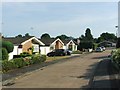

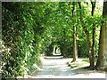
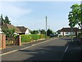

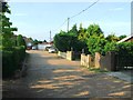
35 photos from this area
Area Information
Key information about the DA3 7AG including its size, population, and administrative classification.
- Area Type
- Postcode
- Area Size
- 5.0 hectares
- Population
- 1578
- Population Density
- 1506 people/km²
House Prices in DA3 7AG
19
Properties
£541,250
Average Sold Price
£276,000
Lowest Price
£845,000
Highest Price
Showing 19 properties
| Address | Type | Beds | Baths | Last Sale Price | Last Sale Date | |
|---|---|---|---|---|---|---|
| High Berry, Main Road, Longfield, DA3 7AG | Detached | 4 | 2 | £825,000 | Feb 2025 | |
| The Stocks, Main Road, Longfield, DA3 7AG | Detached | 2 | - | £276,000 | May 2024 | |
| Chestnut Mill, Main Road, Longfield, DA3 7AG | house | 4 | 3 | £800,000 | Apr 2024 | |
| Tylers Croft, Main Road, Longfield, DA3 7AG | Bungalow | 3 | 1 | £525,000 | Jan 2024 | |
| Skylarks, Main Road, Longfield, DA3 7AG | Detached | 4 | 4 | £845,000 | Jun 2023 | |
| Honeysuckle House, Main Road, Longfield, DA3 7AG | house | - | - | £502,000 | Jun 2021 | |
| Cleveland Court, Main Road, Longfield, DA3 7AG | Bungalow | 3 | 1 | £595,000 | Mar 2021 | |
| Dil Khush, Main Road, Longfield, DA3 7AG | Semi-detached | 5 | 3 | £400,000 | Mar 2020 | |
| The Beeches, Main Road, Longfield, DA3 7AG | Semi-detached | 4 | - | £432,000 | Jan 2018 | |
| Primrose Cottage, Main Road, Longfield, DA3 7AG | Semi-detached | 3 | 2 | £375,000 | Jul 2015 |
Page 1 of 2
Energy Efficiency in DA3 7AG
Amenities
Schools
| Rank | School | Type | Entry gender | Ages |
|---|
Explore more schools in this area
Go to Schools tabDemographics
Household Size
Two person
most common
Accommodation Type
Houses
most common
Tenure
94
majority
Ethnic Group
White
most common
Religion
N/A
most common
Household Composition
N/A
most common
Age
47
median
Adults (30-64 years)
most common
Household Deprivation
N/A
with no deprivation
NS-SEC
43
in Lower managerial occupations
Explore more demographic insights in this area
Go to Demographics tabPlanning
Planning Constraints
- Flood RiskPremium
- Ramsar Wetland SitesPremium
- Area of Outstanding Natural BeautyPremium
- Protected Nature ReservePremium
- Protected WoodlandPremium