Area Overview for DA2 6ZR
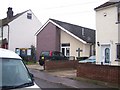
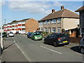
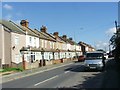
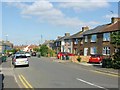
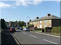
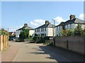
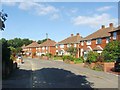
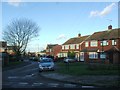
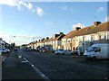
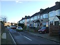
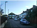
Photos of DA2 6ZR

Area Information
DA2 6ZR is a small residential postcode in Kent, England, nestled along the River Thames south of Greenhithe. With a population of 2,290, it retains a quiet, community-focused character shaped by its riverside setting and historical roots. The area’s gravel soils and chalk deposits have influenced both its landscape and industrial past, with cement works once dominating the marshes. Today, the parish balances its heritage with modern living, offering a mix of older homes and suburban development. Residents benefit from proximity to major transport links, including railway stations and ferry terminals, while the area’s low flood risk ensures peace of mind. Despite its small size, DA2 6ZR provides access to essential services, schools, and retail hubs within a short distance. Its location along the Dartford to Gravesend road makes it a convenient base for commuters, while the nearby Thames offers scenic vistas. For those seeking a blend of history, practicality, and connectivity, DA2 6ZR presents a distinct option in South East England.
- Area Type
- Postcode
- Area Size
- Not available
- Population
- Not available
- Population Density
- Not available
DA2 6ZR is primarily an owner-occupied area, with 63% of properties in private hands. The housing stock consists mainly of houses, which is typical for smaller, residential postcode areas. This suggests a focus on family homes rather than high-density living, contributing to a more spacious and private living environment. The limited size of the area means the property market is likely constrained, with fewer options available compared to larger towns. Buyers should consider the proximity to nearby towns like Dartford and Greenhithe, where additional properties may be found. The predominance of houses may appeal to those seeking larger living spaces, though the market’s small scale could limit competition. For those prioritising security and a stable community, DA2 6ZR’s mix of older homes and suburban development offers a niche opportunity in Kent’s housing landscape.
House Prices in DA2 6ZR
No properties found in this postcode.
Energy Efficiency in DA2 6ZR
Residents of DA2 6ZR have access to a range of amenities within practical reach. Retail options include M&S Dartford and Co-op stores in Colney and Greenhithe, providing essentials and everyday shopping. The railway network, with stations like Stone Crossing and Dartford, connects to major hubs, while ferry services at Tilbury and West Street Pier offer alternative travel routes. The area’s proximity to the River Thames adds a scenic element to daily life, though specific parks or leisure facilities are not detailed in the data. The presence of multiple schools and retail centres suggests a community-oriented lifestyle, with services clustered for convenience. While the data does not specify dining or recreational venues, the transport links imply access to broader leisure options in nearby towns. The mix of retail, transport, and historical setting creates a functional, if modest, lifestyle for residents.
Amenities
Schools
Residents of DA2 6ZR have access to several primary schools, including The Brent Primary School, The Brent Junior School, The Brent Infant School, and a second listing of The Brent Primary School with an Ofsted rating of ‘good’. These schools cater to younger children, providing a range of educational options within the area. The presence of multiple primary schools suggests a focus on early education, though no secondary schools are listed in the data. Families with young children may benefit from the proximity of these institutions, reducing travel time. The ‘good’ rating at one school indicates a baseline standard of education, but further details on curriculum or performance are not available. The concentration of primary schools reflects the area’s demographic profile, which is skewed toward adults, implying a need for local childcare infrastructure.
| Rank | School | Type | Entry gender | Ages |
|---|
Explore more schools in this area
Go to Schools tabDemographics
DA2 6ZR’s population skews toward adults aged 30–64, with a median age of 47. This suggests a community of established residents, many of whom may be homeowners, as 63% of properties are owner-occupied. The area is predominantly composed of houses, reflecting a traditional housing stock that caters to families. The White ethnic group forms the majority, though specific data on diversity is not provided. The age profile indicates a mature demographic, which may influence local services and amenities. With no data on deprivation levels, it is unclear how economic factors might affect quality of life, but the high home ownership rate suggests stability. The absence of younger households or student populations means the area is less likely to experience rapid demographic shifts. This profile aligns with a settled, low-turnover community where long-term residency is common.
Household Size
Accommodation Type
Tenure
Ethnic Group
Religion
Household Composition
Age
Household Deprivation
NS-SEC
Explore more demographic insights in this area
Go to Demographics tabPlanning
Planning Constraints
- Flood RiskPremium
- Ramsar Wetland SitesPremium
- Area of Outstanding Natural BeautyPremium
- Protected Nature ReservePremium
- Protected WoodlandPremium