Area Overview for DA1 2QD
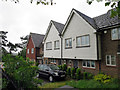
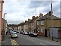
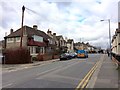
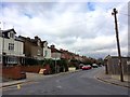
Photos of DA1 2QD


Area Information
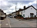
DA1 2QD is a small residential postcode area in England, home to 1,715 people. Its compact size reflects a focused, community-oriented layout, typical of smaller postcode clusters. The area is defined by its proximity to practical amenities and transport links, making it accessible for daily life. With a median age of 47, the population skews towards middle-aged adults, many of whom are likely to be homeowners, given that 54% of properties are owner-occupied. This suggests a stable, long-term demographic, with families and individuals seeking a balanced lifestyle. The area’s character is shaped by its housing stock, which is predominantly houses rather than flats, offering a sense of space and privacy. While specific historical or cultural landmarks are not detailed in available records, the presence of nearby rail stations and retail hubs indicates a functional, well-served environment. For those considering DA1 2QD, the blend of low crime risk, reliable broadband, and proximity to transport networks positions it as a practical choice for those prioritising safety, connectivity, and ease of access to services.
- Area Type
- Postcode
- Area Size
- Not available
- Population
- Not available
- Population Density
- Not available
The property market in DA1 2QD is characterised by a high proportion of owner-occupied homes, with 54% of properties owned by residents rather than rented. This suggests a community where long-term residency is common, and property values may be influenced by local demand for stable, family-friendly housing. The predominant accommodation type is houses, which contrasts with areas where flats or apartments dominate. This housing stock likely appeals to those seeking space, privacy, and a traditional residential layout. Given the small size of the postcode area, the market is likely limited in scale, with properties concentrated in a compact cluster. For buyers, this means competition may be lower than in larger urban areas, but the range of options could be narrower. The focus on owner-occupation also implies that rental availability is limited, making DA1 2QD more suitable for those prioritising homeownership over flexibility in housing tenure.
House Prices in DA1 2QD
No properties found in this postcode.
Energy Efficiency in DA1 2QD
Living in DA1 2QD offers access to a range of nearby amenities within practical reach. The area is served by five retail outlets, including major supermarkets such as Morrisons Daily, Lidl Central, and Tesco Dartford, ensuring residents have convenient access to grocery shopping and daily essentials. These stores likely support a practical, community-focused lifestyle, reducing the need for long journeys to larger centres. The proximity to five rail stations, including Dartford Railway Station and Crayford Station, further enhances connectivity, enabling easy travel for work, leisure, or social purposes. While specific details about parks or leisure facilities are not provided, the combination of retail and transport options suggests a functional environment tailored to everyday needs. The availability of multiple shops and rail links indicates that daily life in DA1 2QD is designed for efficiency, with services clustered to meet residents’ requirements without requiring extensive travel.
Amenities
Schools
| Rank | School | Type | Entry gender | Ages |
|---|
Explore more schools in this area
Go to Schools tabDemographics
The community in DA1 2QD is predominantly composed of adults aged 30–64, with a median age of 47. This suggests a population skewed towards middle-aged individuals, many of whom may be in their prime working years or nearing retirement. Home ownership is relatively high at 54%, indicating a stable housing market where many residents have long-term ties to the area. The majority of properties are houses, rather than flats or apartments, which aligns with the area’s character as a residential cluster prioritising family-friendly living. The predominant ethnic group is White, though specific diversity metrics are not provided in the data. The absence of detailed information on deprivation or socioeconomic variation means the area’s quality of life can be inferred from its safety and connectivity scores, which are both positive. This demographic profile suggests a community with established roots, where residents may prioritise stability, practicality, and access to essential services over high-density urban living.
Household Size
Accommodation Type
Tenure
Ethnic Group
Religion
Household Composition
Age
Household Deprivation
NS-SEC
Explore more demographic insights in this area
Go to Demographics tabPlanning
Planning Constraints
- Flood RiskPremium
- Ramsar Wetland SitesPremium
- Area of Outstanding Natural BeautyPremium
- Protected Nature ReservePremium
- Protected WoodlandPremium