Area Overview for DA1 2NT
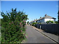
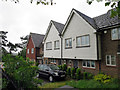
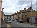
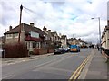
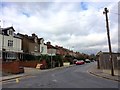
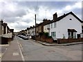
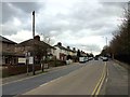
Photos of DA1 2NT


Area Information
Living in DA1 2NT means inhabiting a compact, densely populated residential cluster in Dartford, Kent. With a population of 2,308 spread across 8,566 square metres, the area is characterised by its small-scale, close-knit community. The postcode falls within the Dartford Borough, a part of South East England, and is marked by a mix of historical and contemporary features. The area’s history is steeped in local heritage, including the former Dartford Union Workhouse and West Hill Hospital, which once served as a munitions workers’ hub during World War I. Today, DA1 2NT is a practical choice for those seeking a residential environment with easy access to transport networks and nearby amenities. The high population density—269,428 people per square kilometre—suggests a tightly woven neighbourhood, though the area’s compact size means daily life is centred around immediate surroundings. For buyers, this postcode offers a snapshot of suburban living with a focus on proximity to services, schools, and rail links, though its small footprint means the community is defined by its direct connections rather than sprawling infrastructure.
- Area Type
- Postcode
- Area Size
- 8566 m²
- Population
- Not available
- Population Density
- Not available
The property market in DA1 2NT is predominantly owner-occupied, with 68% of homes owned by residents rather than rented. This reflects a community of long-term residents rather than a transient rental market. The accommodation type is largely houses, which is unusual for a postcode of this size but aligns with the area’s historical and suburban character. The high proportion of owner-occupied properties suggests that buyers here are likely purchasing for long-term residence rather than investment. The small area size means the housing stock is limited, and the immediate surroundings offer few alternative options. For prospective buyers, this implies a competitive market with limited supply, particularly for houses. The focus on owner-occupation also suggests that properties are likely to be well-maintained, with residents prioritising stability over short-term gains.
House Prices in DA1 2NT
No properties found in this postcode.
Energy Efficiency in DA1 2NT
The lifestyle in DA1 2NT is shaped by its proximity to retail and transport hubs. Nearby amenities include major supermarkets such as Tesco Dartford, Morrisons Daily, and Lidl Central, providing convenience for grocery shopping and daily errands. The area’s rail network, with stations like Dartford Railway Station, connects residents to broader regional and national transport systems, enhancing mobility. While the data does not mention parks or leisure facilities explicitly, the historical context of the area suggests potential for local green spaces or heritage sites. The compact nature of the postcode means that daily life revolves around immediate access to shops, transport, and the schools that define the community. For residents, this balance of practicality and connectivity offers a functional lifestyle, though the absence of specific details on leisure options means buyers must consider nearby areas for recreational activities.
Amenities
Schools
DA1 2NT is served by a range of primary and secondary schools, including Dartford West Boys’ School, Dartford Science & Technology College, and Dartford Grammar School for Girls. The latter, a primary school with an Ofsted rating of outstanding, highlights the area’s strong educational provision. Dartford Grammar School, listed as both a primary and academy school, also contributes to the local school network. The presence of multiple primary schools suggests a focus on early education, while the academy designation at Dartford Grammar School indicates a higher standard of teaching. For families, the mix of school types—primarily primary with one academy—offers a range of options, though secondary education may require commuting to nearby areas. The good Ofsted rating at one school underscores the area’s commitment to educational quality, though the absence of specific data on secondary school performance means buyers must consider proximity to larger institutions.
| Rank | School | Type | Entry gender | Ages |
|---|
Explore more schools in this area
Go to Schools tabDemographics
DA1 2NT has a median age of 47, with the majority of residents falling into the 30-64 age range. This suggests a community skewed towards middle-aged adults, likely with established careers and families. Home ownership is strong here, with 68% of properties owner-occupied, indicating a stable, long-term resident base. The predominant accommodation type is houses, which aligns with the area’s residential character and the absence of high-density housing. Ethnically, the population is predominantly White, though no specific data on diversity or deprivation is provided. The age profile implies a mature demographic, potentially with lower turnover rates and a focus on local amenities. For buyers, this demographic structure suggests a neighbourhood with a focus on stability rather than transient populations. The lack of specific data on deprivation means quality of life can only be inferred from the available metrics, such as safety scores and access to services.
Household Size
Accommodation Type
Tenure
Ethnic Group
Religion
Household Composition
Age
Household Deprivation
NS-SEC
Explore more demographic insights in this area
Go to Demographics tabPlanning
Planning Constraints
- Flood RiskPremium
- Ramsar Wetland SitesPremium
- Area of Outstanding Natural BeautyPremium
- Protected Nature ReservePremium
- Protected WoodlandPremium