Area Overview for DA1 1YN
Photos of DA1 1YN


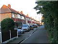
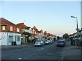
77 photos from this area
Area Information
Key information about the DA1 1YN including its size, population, and administrative classification.
- Area Type
- Postcode
- Area Size
- 6964 m²
- Population
- 2059
- Population Density
- 10020 people/km²
House Prices in DA1 1YN
31
Properties
£349,055
Average Sold Price
£235,000
Lowest Price
£537,500
Highest Price
Showing 31 properties
| Address | Type | Beds | Baths | Last Sale Price | Last Sale Date | |
|---|---|---|---|---|---|---|
| 40 The Brent, Dartford, DA1 1YN | Terraced | 4 | 1 | £480,000 | Sep 2023 | |
| 34 The Brent, Dartford, DA1 1YN | house | 5 | 2 | £537,500 | Aug 2019 | |
| 22 The Brent, Dartford, DA1 1YN | Detached | 3 | 2 | £310,000 | May 2019 | |
| 30 The Brent, Dartford, DA1 1YN | Semi-detached | 1 | 1 | £375,000 | Dec 2018 | |
| 36 The Brent, Dartford, DA1 1YN | Terraced | 5 | 2 | £460,000 | Aug 2017 | |
| 38 The Brent, Dartford, DA1 1YN | Terraced | 3 | 2 | £255,000 | Oct 2016 | |
| 24 The Brent, Dartford, DA1 1YN | house | - | - | £235,000 | Nov 2013 | |
| 44 The Brent, Dartford, DA1 1YN | Semi-detached | - | - | £249,999 | Oct 2008 | |
| 26 The Brent, Dartford, DA1 1YN | Semi-detached | - | - | £239,000 | Sep 2007 | |
| First Floor, 18-20 The Brent, Dartford, DA1 1YN | Flat | 1 | 1 | - | - |
Page 1 of 4
Energy Efficiency in DA1 1YN
Amenities
Schools
| Rank | School | Type | Entry gender | Ages |
|---|
Explore more schools in this area
Go to Schools tabDemographics
Household Size
Family (3-5 people)
most common
Accommodation Type
Houses
most common
Tenure
67
majority
Ethnic Group
White
most common
Religion
N/A
most common
Household Composition
N/A
most common
Age
47
median
Adults (30-64 years)
most common
Household Deprivation
N/A
with no deprivation
NS-SEC
31
in Lower managerial occupations
Explore more demographic insights in this area
Go to Demographics tabPlanning
Planning Constraints
- Flood RiskPremium
- Ramsar Wetland SitesPremium
- Area of Outstanding Natural BeautyPremium
- Protected Nature ReservePremium
- Protected WoodlandPremium