Area Overview for DA1 1FD
Photos of DA1 1FD


Area Information
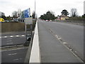
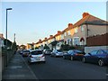
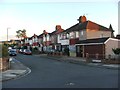
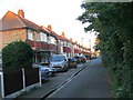
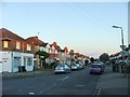
DA1 1FD is a small residential cluster in the Dartford Borough of Kent, situated near the town centre at coordinates 51.434664, 0.235696. With a population of 1,524, this area is compact yet well-connected, blending suburban tranquillity with proximity to urban amenities. The postcode falls within Brent Ward, an electoral division noted for its Grade II listed buildings, including Overy Street in New Town, Dartford. Daily life here is shaped by its location: residents benefit from nearby rail links, ferry terminals, and a mix of retail and community hubs. The area’s character is defined by its modest scale, with homes predominantly in private ownership. While it lacks large-scale infrastructure, its accessibility to Dartford’s core and surrounding services makes it a practical choice for those prioritising convenience over sprawling landscapes. The presence of notable historical architecture adds a layer of local heritage, though the community remains focused on everyday living, with schools, shops, and transport options within practical reach.
- Area Type
- Postcode
- Area Size
- Not available
- Population
- Not available
- Population Density
- Not available
DA1 1FD is a predominantly owner-occupied area, with 69% of homes in private hands. The accommodation type is almost exclusively houses, which is uncommon in many modern residential zones where flats or apartments dominate. This suggests a market catering to families or individuals seeking standalone properties, rather than rental-focused developments. The small scale of the area means the housing stock is limited, but the focus on houses may appeal to buyers prioritising space and privacy. Given the high home ownership rate, the area is unlikely to be a hotspot for investors or renters, though the proximity to Dartford’s amenities could make it attractive for commuters. For buyers, the challenge lies in the limited inventory, but the existing properties reflect a stable, low-risk market with no apparent planning constraints that might deter purchase.
House Prices in DA1 1FD
No properties found in this postcode.
Energy Efficiency in DA1 1FD
The lifestyle in DA1 1FD is shaped by its proximity to retail, transport, and community hubs. Nearby amenities include five retail outlets such as Tesco Dartford E and Co-op Colney, offering everyday shopping needs. Rail stations like Dartford Railway Station and Stone Crossing provide easy access to regional and urban centres, while ferry terminals like Tilbury Ferry Terminal connect to nearby waterways. The area’s modest scale means these amenities are within practical reach, supporting a convenient daily life. Though the data does not specify parks or leisure facilities, the presence of multiple retail and transport options suggests a focus on accessibility over large-scale recreational spaces. For residents, this means a balance of practicality and proximity, with no need to travel far for essentials.
Amenities
Schools
The nearest schools to DA1 1FD include The Leigh City Technology College, a secondary school offering education for older students, and Sir Geoffrey Leigh Academy, an academy with a Good Ofsted rating. The mix of school types provides options for families at different stages of education, from secondary schooling to academy-based institutions. The presence of a rated academy suggests a commitment to quality education, though no primary schools are listed in the data. For parents, this means access to established secondary education but may require travel for younger children. The absence of primary schools within the immediate area could influence decisions for families with younger dependents, though the proximity to Dartford town centre may offer alternative options.
| Rank | School | Type | Entry gender | Ages |
|---|
Explore more schools in this area
Go to Schools tabDemographics
The population of DA1 1FD skews towards adults aged 30–64, with a median age of 47. This suggests a mature, settled community, likely with established families and professionals. Home ownership rates are high at 69%, indicating a stable housing market where most residents live in their own homes rather than renting. The accommodation type is predominantly houses, which aligns with the area’s residential character and suggests a preference for private, family-oriented living spaces. The predominant ethnic group is White, though no specific data on diversity or deprivation is provided. The age profile and ownership figures imply a community focused on long-term residency rather than transient populations. For quality of life, the lack of mention of deprivation or social housing suggests a relatively uniform demographic, though this does not necessarily reflect the full picture of socioeconomic variation.
Household Size
Accommodation Type
Tenure
Ethnic Group
Religion
Household Composition
Age
Household Deprivation
NS-SEC
Explore more demographic insights in this area
Go to Demographics tabPlanning
Planning Constraints
- Flood RiskPremium
- Ramsar Wetland SitesPremium
- Area of Outstanding Natural BeautyPremium
- Protected Nature ReservePremium
- Protected WoodlandPremium