Area Overview for CT6 8LL
Photos of CT6 8LL
Area Information
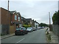
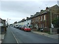
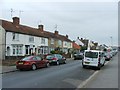
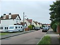
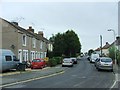
CT6 8LL represents a highly concentrated residential district within the wider Herne Bay area of Kent. This specific postcode covers a limited cluster of properties spread across just 5628 square metres. You will find a population of 1575 residents living in this compact footprint, resulting in a remarkably high population density of 279,831 people per square kilometre. This specific cluster sits within the West Bay Ward, under the administration of Canterbury City Council. The location places you in a coastal setting near Herne Bay, distinct from other settlements named West Bay in the UK. Living in CT6 8LL means settling into a small, tightly defined neighbourhood where the immediate surroundings are dominated by housing. The area functions as a residential hub for a significant portion of the local community. You gain access to the practical advantages of a coastal town while dealing with the limitations of a small, densely populated zone. Daily life here revolves around the immediate vicinities and the nearby amenities that serve the broader Herne Bay population. Understanding this specific geography helps you evaluate how you will navigate the area and access local services.
- Area Type
- Postcode
- Area Size
- 5628 m²
- Population
- Not available
- Population Density
- Not available
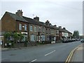
The property market in CT6 8LL is firmly defined by owner-occupancy rather than rental investment. With 62% of homes owned outright or with a mortgage, the area displays the characteristics of a traditional family settlement. Houses dominate the landscape, meaning you will primarily encounter detached or semi-detached properties rather than flats or purpose-built rentals. This density of 279,831 people per square kilometre creates a specific dynamic for buyers because the land is spoken for. The small area size of 5628 square metres limits the volume of stock available, making competition potential high for suitable houses. When looking at homes in CT6 8LL, you are entering a market where established owners have resided for years. The lack of rental housing data in the immediate vicinity further supports the view that this is a buy-to-live zone. Prospective buyers should focus on the limited number of houses rather than expecting a wide variety of tenanted properties. Understanding this ownership structure helps you gauge the stability of the neighbourhood and the type of neighbours likely to be in your street.
House Prices in CT6 8LL
No properties found in this postcode.
Energy Efficiency in CT6 8LL
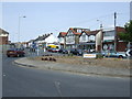
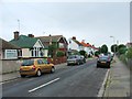
Living in CT6 8LL offers practical access to retail and transport hubs within Herne Bay. You can shop at the Co-op Sea, Lidl Herne, or the Tesco Herne Bay superstore, all located within practical reach. These five retail outlets cover your daily grocery and essentials needs. The area claims three railway stations within its accessible network, including Herne Bay Railway Station, Chestfield & Swalecliffe Railway Station, and Whitstable Railway Station. This rail connectivity connects you to Canterbury, London, and other major Kent destinations. The combination of five retail options and five accessible rail links makes daily commuting and shopping straightforward. You do not need to travel far for basic necessities or to catch a train. The lifestyle is defined by convenience and proximity to the main town services. Shops and stations are not far away, allowing for easy errands and smooth travel plans. This amenity mix ensures that residents can maintain an active life despite living in a clustered postcode.
Amenities
Schools
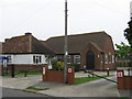
Families living in CT6 8LL have access to primary education through Hampton Primary School. This institution is located in the immediate vicinity of the postcode and holds an Ofsted rating of good. The school serves the local community as the main point of primary education access. There are no secondary schools listed in the immediate data for this specific postcode cluster. You will need to look beyond the immediate mile to find secondary options for older children. The presence of a single primary school with a positive rating suggests a reliable local education provider. This setup is typical for clusters within larger townships like Herne Bay, where specific primary institutions serve smaller zones. Living in CT6 8LL ensures your younger children attend a rated school without commencing long journeys. The good rating provides assurance regarding the standard of instruction for the local catchment area.
| Rank | School | Type | Entry gender | Ages |
|---|---|---|---|---|
| 1 | Hampton Primary School | primary | N/A | N/A |
| 2 | Hampton Primary School | primary | N/A | N/A |
Explore more schools in this area
Go to Schools tabDemographics
The community in CT6 8LL reflects a mature demographic profile with a median age of 47 years. The majority of residents fall into the adult category, specifically those aged between 30 and 64 years. This age group forms the backbone of the local population, suggesting a settlement that attracts established families rather than transient populations or students. Home ownership stands at a strong 62% within this postcode, indicating that most households are finance-independent buyers. The predominant accommodation type consists of houses, which aligns with the ownership figures and the preference of adults in this age bracket. You will find that the ethnic composition is predominantly White, mirroring the wider patterns often seen in established coastal towns in the South East. There is no data on specific deprivation indices, but the high ownership rate and adult focus suggest a relatively stable economic environment. Residents look for stability and space within the constraints of this small area. The demographics indicate a settled community where long-term homeownership is the norm rather than the exception.
Household Size
Accommodation Type
Tenure
Ethnic Group
Religion
Household Composition
Age
Household Deprivation
NS-SEC
Explore more demographic insights in this area
Go to Demographics tabPlanning
Planning Constraints
- Flood RiskPremium
- Ramsar Wetland SitesPremium
- Area of Outstanding Natural BeautyPremium
- Protected Nature ReservePremium
- Protected WoodlandPremium
- Crime RiskPremium