Area Overview for CT6 8LG
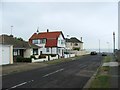
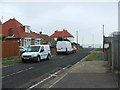
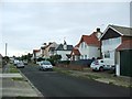
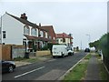
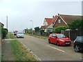
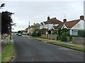
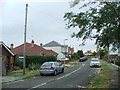
Photos of CT6 8LG

Area Information
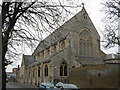
Living in CT6 8LG means inhabiting a small, defined residential cluster within Herne Bay, a seaside town on Kent’s north coast. The area’s population of 1542 suggests a tight-knit community, with daily life shaped by its proximity to the Queen Victoria Memorial Hospital, a 1930s building that remains a focal point. This postcode lies within Heron Ward, a suburban zone that blends residential living with local healthcare facilities. The area’s compact size means amenities and services are within practical reach, though its character is defined by its modest scale and the presence of the hospital’s inpatient facilities. Residents here are likely to value convenience, with the area’s proximity to coastal towns like Herne Bay offering access to seaside walks, local shops, and transport links. The demographic profile—skewed toward adults aged 30-64—hints at a community of professionals and families seeking stability, though the 43% home ownership rate suggests a significant portion of residents rent. This postcode is not for those seeking sprawling estates but rather a compact, functional living environment with a clear focus on accessibility and local services.
- Area Type
- Postcode
- Area Size
- Not available
- Population
- 1542
- Population Density
- 5988 people/km²
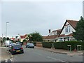
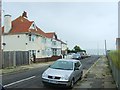
The property market in CT6 8LG is characterised by a 43% home ownership rate, indicating that over half of residents rent. This suggests a rental market that may dominate, with flats being the primary accommodation type. The prevalence of flats, often associated with rental properties, implies a housing stock that caters to smaller households or those seeking low-maintenance living. Given the area’s compact size, property availability is likely limited, with buyers needing to consider nearby suburbs or the broader Herne Bay area for more options. The mix of renters and owners may reflect a balance between long-term residents and those in temporary housing. For buyers, this means competition for available properties, particularly flats, and a need to evaluate the area’s suitability for long-term investment against its rental potential. The small postcode’s boundaries also mean that immediate surroundings, such as adjacent wards, may hold more housing diversity.
House Prices in CT6 8LG
No properties found in this postcode.
Energy Efficiency in CT6 8LG
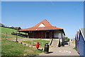
Residents of CT6 8LG have access to five retail venues within practical reach, including Tesco Herne Bay, Co-op Sea, and Morrisons Herne. These shops provide essential services, from groceries to general retail, reducing the need for long trips. The rail network further enhances convenience, with four stations offering links to Herne Bay, Chestfield & Swalecliffe, and Whitstable. These stations connect to broader transport routes, enabling easy travel for work, leisure, or shopping. The area’s proximity to the Queen Victoria Memorial Hospital also means healthcare is readily available. While the data does not mention parks or leisure facilities, the presence of a seaside town nearby suggests access to coastal walks and recreational spaces. The combination of retail, transport, and healthcare services creates a lifestyle that balances practicality with the amenities of a small town.
Amenities
Schools
The nearest school to CT6 8LG is St Philip Howard Catholic Primary School, a primary institution serving the local community. No secondary schools are listed in the data, meaning families may need to look beyond the immediate area for secondary education. The presence of a primary school is a key consideration for families, though the absence of a secondary school nearby could affect long-term planning. Parents might need to factor in commuting times to larger schools in Herne Bay or nearby towns. The school’s type—Catholic—suggests a specific religious affiliation, though no Ofsted rating or performance data is available. This means prospective residents must rely on local recommendations or broader area reviews to assess the quality of education. For those prioritising proximity to schools, the primary institution is a positive, but secondary options remain an unknown variable.
| Rank | School | Type | Entry gender | Ages |
|---|---|---|---|---|
| 1 | St Philip Howard Catholic Primary School | primary | N/A | N/A |
Explore more schools in this area
Go to Schools tabDemographics
CT6 8LG’s population of 1542 is predominantly adults aged 30-64, with a median age of 47. This suggests a community of middle-aged professionals and families, though the 43% home ownership rate indicates a rental-heavy market. The accommodation type is primarily flats, reflecting a housing stock suited to smaller households or those prioritising ease of maintenance. The predominant ethnic group is White, though no specific data on diversity or deprivation levels is provided. The age profile implies a stable, established population, with fewer young families or retirees compared to other areas. The absence of detailed diversity statistics means the community’s cultural makeup remains unclear, but the age range suggests a focus on career-oriented residents and those in mid-life. The 43% ownership rate also hints at a rental market that may cater to transient populations or those seeking short-term housing solutions.
Household Size
Accommodation Type
Tenure
Ethnic Group
Religion
Household Composition
Age
Household Deprivation
NS-SEC
Explore more demographic insights in this area
Go to Demographics tabPlanning
Planning Constraints
- Flood RiskPremium
- Ramsar Wetland SitesPremium
- Area of Outstanding Natural BeautyPremium
- Protected Nature ReservePremium
- Protected WoodlandPremium
- Crime RiskPremium