Area Overview for CT6 6TU
Photos of CT6 6TU


Area Information
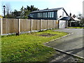
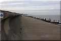
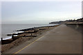
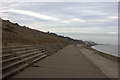
Beltinge forms the easternmost part of the urban area of Herne Bay in Kent, defining a low-density residential cluster within Canterbury City Council. This specific postcode, CT6 6TU, covers an area of 2928 square metres and serves a population of 1581 residents. The neighbourhood sits on the fringe of the North Downs, offering views over the Thames Estuary and North Sea while maintaining a distinct separation from the coast's busy tourism zones. Its history dates back to the Domesday Book of 1086 as Beltunga, evolving from swine pastures and saltworks into a modern suburb characterised by maritime heritage and oast house countryside. Today, the area functions as a coastal suburb with gently sloping cliffs overlooking the sea, blending Anglo-Saxon settlement roots with Victorian seaside influences and post-war developments. You will find yourself living in a fringe community that balances sustainable coastal living with proximity to urban amenities. The layout supports a quiet existence away from the main thoroughfares, making it an ideal choice for those seeking the character of a historic hamlet without isolation from city centres.
- Area Type
- Postcode
- Area Size
- 2928 m²
- Population
- Not available
- Population Density
- Not available
Homes in CT6 6TU reflect a market dominated by owner-occupiers, with 79% of households owning their properties outright or with a mortgage. The accommodation stock consists primarily of houses, catering to families and older residents who prefer single-family dwellings over flats or terraced homes. This high ownership figure signals that the area is not a rental hotspot but rather a place for people to put down roots. The density of 539,997 people per square kilometre, while seemingly inflated by the tiny census area size, points to a cluster of homes rather than a sprawling sprawl of land. When you look at CT6 6TU, you are looking at a collection of individual properties built over varying historical periods, from 1930s Arts & Crafts semis to 1960s bungalows. The market here is likely stable, driven by demand from those seeking established coastal locations. Buyers should focus on the maintenance requirements of these older houses, given the area's coastal position. The prevalence of houses over multi-unit developments means lower immediate noise complaints and a more private living environment for you.
House Prices in CT6 6TU
No properties found in this postcode.
Energy Efficiency in CT6 6TU
Living in CT6 6TU offers immediate access to essential services and leisure facilities within practical reach of your home. Five retail venues sit nearby, specifically Co-op Herne, Sainsburys Margate, and Tesco Mortimer, ensuring you have grocery and household shopping options without long drives. For transport needs, four railway stations provide connectivity, such as Herne Bay Railway Station and Sturry Railway Station, facilitating easy access to London and other Kent towns. The area research highlights the presence of the Saxon Shore Way footpath, allowing you to enjoy walking routes through historic landscapes. Notable landmarks include St Bartholomew's Church, built in 1908, and WWII pillboxes along the promenade which add historical interest to your walks. The proximity to the Thanet Coast SSSI offers ecological significance and opportunities for birdwatching, with species like skylarks frequenting the maritime grasslands. You will find your daily life supported by a mix of historic charm and modern convenience, anchored by specific named amenities that serve the local population of 1581.
Amenities
Schools
| Rank | School | Type | Entry gender | Ages |
|---|
Explore more schools in this area
Go to Schools tabDemographics
The community in CT6 6TU leans heavily towards later-life living, with a median age of 47 years. The most common age range among residents consists of those elderly and over 65 years old, indicating a neighbourhood dominated by mature households. This demographic profile is reflected in a very high home ownership rate of 79%, suggesting a population that has settled permanently rather than renting transiently. Houses comprise the primary accommodation type, aligning with family structures and older demographics who prefer detached or semi-detached living spaces. The area remains predominantly White in terms of ethnicity, mirroring the traditional settlement patterns of the region. You are likely to encounter a stable community where long-term residents know one another well. The high proportion of owner-occupiers coupled with the age demographic means the local economy circulates wealth within established households. This structure supports a quieter life without the transient nature often found in student towns or commuter hubs. For you, the daily rhythm here will reflect the needs and rhythms of an older, established population.
Household Size
Accommodation Type
Tenure
Ethnic Group
Religion
Household Composition
Age
Household Deprivation
NS-SEC
Explore more demographic insights in this area
Go to Demographics tabPlanning
Planning Constraints
- Flood RiskPremium
- Ramsar Wetland SitesPremium
- Area of Outstanding Natural BeautyPremium
- Protected Nature ReservePremium
- Protected WoodlandPremium