Area Overview for CT6 6HD
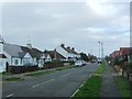
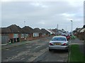
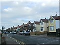
Photos of CT6 6HD

Area Information
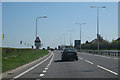
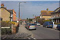
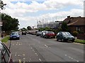
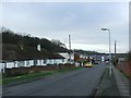
CT6 6HD represents a specific postcode cluster within the larger post-war coastal suburb of Beltinge, situated on the eastern fringe of Herne Bay in Kent. This small residential area covers just over two thousand square metres and accommodates a population of 1,535 people. The location sits within Canterbury City Council as part of the Herne and Broomfield Parish, offering a unique blend of coastal proximity and established community infrastructure. Residents live in a low-density environment characterised by gentle slopes that overlook both the Thames Estuary and the North Sea. Daily life here is defined by its position on the northern edge of the urban area, bordered by the North Downs and the Coastal Plain region. The area evolved from historical saltworks and swine pastures recorded in the Domesday Book into a modern residential zone. The immediate surroundings feature maritime heritage sites, including WWII pillboxes along the promenade and the Saxon Shore Way footpath. Living in CT6 6HD means occupying a space where oast house countryside meets structured suburban living. You are located close to the Thanet Coast Site of Special Scientific Interest, which contributes to the ecological significance of the neighbourhood. This small yet distinct part of the community offers a tangible connection to local history and natural landscapes without the density of larger town centres.
- Area Type
- Postcode
- Area Size
- 2008 m²
- Population
- Not available
- Population Density
- Not available
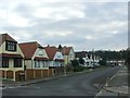
The property market in CT6 6HD is dominated by homeownership, with 91% of the population owning their dwellings. This statistic paints a clear picture of the local housing landscape: it is an area for people seeking to put down roots rather than those looking for flexible rentals. Every available data point confirms that houses are the primary form of accommodation, consistent with the low-density residential nature of Beltinge. You are unlikely to find purpose-built flats or high-rise blocks within this postcode cluster. Buying a home here means joining a community of owner-occupiers who value stability and local investment. The accommodation type data shows no significant presence of social housing or high-density blocks. This scarcity of rental options implies that the market is driven by private sales and inherited properties. As you look at homes in CT6 6HD, you are viewing stock that has served previous generations, likely blending older Victorian and Arts & Crafts influences with post-war modernism. The high home ownership percentage suggests that value retention and long-term residency are priorities for both current buyers and existing residents.
House Prices in CT6 6HD
No properties found in this postcode.
Energy Efficiency in CT6 6HD
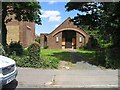
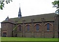
Your daily lifestyle in CT6 6HD revolves around a compact selection of amenities that are within practical reach. For your shopping needs, you have five retail venues nearby, including the Tesco Herne, Tesco Mortimer, and Sainsburys Margate. These supermarkets provide essential goods without requiring a long journey into a larger town centre. Dining and convenience stores in Herne Bay satisfy your weekly needs, keeping costs manageable while maintaining community connections. Commuting and leisure are supported by five key railway stations in the immediate vicinity. Herne Bay Railway Station serves as a primary hub, but you also have Chestfield and Swalecliffe Railway Station and Sturry Railway Station nearby. These options provide flexibility for your travel schedule. Beyond commerce and transport, the area offers cultural and recreational highlights. The Saxon Shore Way footpath runs through your neighbourhood, connecting you to the coastline and historical sites. You can explore WWII pillboxes along the promenade or visit St Bartholomew's Church, built in 1908, for local historic interest. Evenings and weekends are enriched by the adjacent Thanet Coast Site of Special Scientific Interest, offering opportunities to observe skylarks and maritime grasslands. Living in CT6 6HD balances suburban convenience with accessible coastal heritage.
Amenities
Schools
| Rank | School | Type | Entry gender | Ages |
|---|
Explore more schools in this area
Go to Schools tabDemographics
The community of CT6 6HD is defined by stability and maturity, with a median age of 47 years. The most common age range among residents is the elderly, comprising those over 65 years old. This demographic profile suggests a neighbourhood established by retirees and long-term families rather than transient millennial professionals. Home ownership stands at an impressive 91%, indicating that the vast majority of households own their properties outright or with a mortgage. This high concentration of owner-occupiers creates a settled environment where residents have deep roots in the local area. Accommodation types are almost exclusively houses, reflecting the low-density character of Beltinge. You will find a mix of architectural styles, from 1930s Arts & Crafts semi-detached homes to 1960s bungalows and post-war developments. The predominant ethnic group is White, maintaining traditional community demographics common in many Kentish suburbs. The historical roots of the area, described in local records as a hamlet of swine pastures and saltworks under Herne Manor, have translated into a village-like atmosphere. People living here value stability, and the high home ownership rate confirms that this remains a family-oriented environment where change happens slowly. The housing stock supports a lifestyle where residents are less likely to move frequently compared to high-letting rental districts.
Household Size
Accommodation Type
Tenure
Ethnic Group
Religion
Household Composition
Age
Household Deprivation
NS-SEC
Explore more demographic insights in this area
Go to Demographics tabPlanning
Planning Constraints
- Flood RiskPremium
- Ramsar Wetland SitesPremium
- Area of Outstanding Natural BeautyPremium
- Protected Nature ReservePremium
- Protected WoodlandPremium
- Crime RiskPremium