Area Overview for CT6 5SR
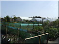
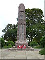
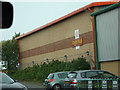
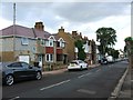
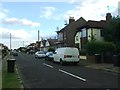
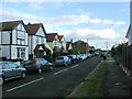
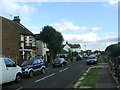
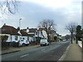
Photos of CT6 5SR


Area Information
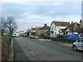
CT6 5SR sits within Herne Bay, an electoral ward on the north Kent coast under the City of Canterbury district. This specific postcode covers a small residential cluster comprising just 1,648 square metres of land. You will find a population of 1,404 people living here, creating a tightly knit neighbourhood with significant proximity between homes. The area functions as a quiet suburban zone defined by its residential character and immediate integration with the wider Herne Bay town environment. Life in CT6 5SR centres around daily convenience and a strong sense of local identity. You are part of a community where the definition of "home" often extends beyond physical walls to encompass the local institutions that sustain the ward. The Queen Victoria Memorial Hospital, a notable landmark nearby, dates back to the 1930s and underwent refurbishment to reopen recently. This healthcare facility anchors the area, providing essential services to residents working from nearby or seeking medical care. Despite its small footprint, the ward supports a complete daily life, blending residential housing with significant public infrastructure in a coastal setting.
- Area Type
- Postcode
- Area Size
- 1648 m²
- Population
- Not available
- Population Density
- Not available
The housing stock in CT6 5SR is defined by its composition of houses, indicating a traditional residential area rather than a high-rise or urban rental pocket. With 51 per cent of the population owning their homes, this is an area where long-term residents hold a significant portion of the property market. You are more likely to purchase a family home intended for occupation rather than viewing a predominantly buy-to-let zone. This ownership rate suggests a stable market where sellers have lived in their properties for considerable periods. Buyers looking for homes in CT6 5SR should expect single-family dwellings suited to the suburban nature of the Herne Bay ward. The small total area of 1,648 square metres implies limited new development potential within this specific boundary, reinforcing the area's quiet, established character. As you search for properties, focus on the surrounding streets and immediate Neighbourhood Authority zones, as the specific code covers a very confined cluster typical of older seaside developments where land value is high per square metre.
House Prices in CT6 5SR
No properties found in this postcode.
Energy Efficiency in CT6 5SR
Living in CT6 5SR puts you within practical reach of essential retail and leisure facilities in Herne Bay. You have access to five major retail units nearby, including Aldi Herne, Morrisons Herne, and Tesco Herne. These supermarkets ensure you do not need to travel far for groceries or household supplies. For those requiring additional transport links, four railway stations serve the broader area, with Herne Bay Railway Station being the most direct option for connecting to the rest of Kent and London. The lifestyle here balances convenience with coastal charm. You can walk to the shops for daily chores then head to the beach or nearby parks in the afternoon. The Queen Victoria Memorial Hospital also serves as a local landmark, adding a layer of civic importance to the daily routine. While the area is small, the density of amenities like the three named supermarkets ensures your weekly shopping does not require a significant drive. This mix of retail and transport options makes CT6 5SR a practical choice for families who value efficiency alongside a seaside location.
Amenities
Schools
| Rank | School | Type | Entry gender | Ages |
|---|
Explore more schools in this area
Go to Schools tabDemographics
The community in CT6 5SR is mature, with a median age of 47 years old, and adults between 30 and 64 years represent the most common age group. This demographic suggests a neighbourhood settled by families and established professionals rather than transient workers or young students. Over half of the residents, specifically 51 per cent, own their homes outright or have a mortgage. The remaining households likely include long-term tenants or those in transitional living arrangements. Houses dominate your accommodation options within this postcode, meaning you are looking at residential property rather than flats or terraced blocks. The population is predominantly White, reflecting the typical composition of many established seaside towns in Kent. With over 850,000 people per square kilometre recorded in the data, the density figure appears anomalously high for such a small area and should be interpreted as a data point reflecting the concentration of the small 1,404 population across the specific 1,648 square metre boundary. You are buying into a stable community where older residents often remain in their family homes, contributing to a slower pace of life compared to urban centres.
Household Size
Accommodation Type
Tenure
Ethnic Group
Religion
Household Composition
Age
Household Deprivation
NS-SEC
Explore more demographic insights in this area
Go to Demographics tabPlanning
Planning Constraints
- Flood RiskPremium
- Ramsar Wetland SitesPremium
- Area of Outstanding Natural BeautyPremium
- Protected Nature ReservePremium
- Protected WoodlandPremium
- Crime RiskPremium