Area Overview for CT6 5LW
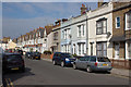
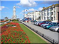
Photos of CT6 5LW


Area Information
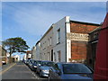
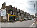
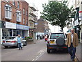
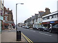
Living in CT6 5LW means being part of a small, residential cluster in the north Kent coast, within the seaside town of Herne Bay. The area is defined by its proximity to the Queen Victoria Memorial Hospital, a 1930s building that serves as a focal point for the community. With a population of 1,807, CT6 5LW is a compact postcode area, typical of suburban/residential zones in the City of Canterbury district. Daily life here is shaped by its location on the North Sea coast, offering easy access to coastal walks and nearby towns like Herne Bay and Whitstable. The area is not densely populated, which means a quieter, more intimate living environment compared to larger urban centres. Its small size means residents are likely to know their neighbours, and local amenities are within practical reach. The mix of flats and the relatively low population density suggests a community that values convenience over sprawling development. For those seeking a place with a balance of coastal charm and practical living, CT6 5LW offers a distinct, manageable footprint within a broader regional network.
- Area Type
- Postcode
- Area Size
- Not available
- Population
- Not available
- Population Density
- Not available
The property market in CT6 5LW is characterised by a 42% home ownership rate, which is notably lower than the national average. This suggests that a significant portion of the housing stock is rented, possibly due to the area’s small size and the prevalence of flats. The accommodation type is predominantly flats, which are typically more suited to rental markets than owner-occupied homes. This dynamic may make CT6 5LW a less attractive option for buyers seeking long-term investment, as the market is likely more responsive to rental demand than property appreciation. The limited population size and compact footprint of the area mean that the housing stock is unlikely to expand significantly, which could create competition among buyers. For those considering the area, the focus on flats and lower ownership rates implies a need to evaluate the local rental market and potential for property value growth carefully.
House Prices in CT6 5LW
No properties found in this postcode.
Energy Efficiency in CT6 5LW
Residents of CT6 5LW have access to a range of nearby amenities that support daily life. The area includes five retail outlets, such as Morrisons Herne, Aldi Herne, and Iceland Herne, providing essential shopping and grocery needs within walking or short driving distance. For transport, four railway stations are available, including Herne Bay Railway Station and Whitstable Railway Station, offering connections to regional destinations. While the area does not have major parks or leisure facilities within its boundaries, its proximity to Herne Bay and the North Sea coast implies access to coastal walks and open spaces. The presence of these amenities suggests a lifestyle that balances convenience with the quieter aspects of suburban living. The Queen Victoria Memorial Hospital, located nearby, adds to the area’s practicality, ensuring healthcare services are within reach. These factors collectively create a functional, low-stress environment for residents.
Amenities
Schools
| Rank | School | Type | Entry gender | Ages |
|---|
Explore more schools in this area
Go to Schools tabDemographics
The population of CT6 5LW is 1,807, with a median age of 47, indicating a community skewed towards middle-aged adults. The most common age range is 30–64 years, suggesting a stable demographic with a focus on working-age residents. Home ownership rates are 42%, which is lower than the national average, pointing to a market where rental properties may be more prevalent. The predominant accommodation type is flats, reflecting a housing stock that prioritises density over detached homes. The predominant ethnic group is White, with no specific data provided on other groups. This demographic profile suggests a community that may have limited generational turnover, with a focus on established households rather than young families or students. The absence of data on deprivation levels means quality of life factors like access to services or employment opportunities cannot be fully contextualised, but the age distribution and ownership figures imply a steady, low-volatility population.
Household Size
Accommodation Type
Tenure
Ethnic Group
Religion
Household Composition
Age
Household Deprivation
NS-SEC
Explore more demographic insights in this area
Go to Demographics tabPlanning
Planning Constraints
- Flood RiskPremium
- Ramsar Wetland SitesPremium
- Area of Outstanding Natural BeautyPremium
- Protected Nature ReservePremium
- Protected WoodlandPremium
- Crime RiskPremium