Area Overview for CT6 5BD
Photos of CT6 5BD


Area Information
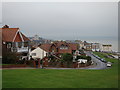
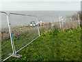
CT6 5BD is a small residential postcode cluster in Herne Bay, a seaside town on Kent’s north coast. With a population of 1422, it is a compact community defined by its suburban character and proximity to the Queen Victoria Memorial Hospital, a 1930s building recently refurbished for inpatient care. The area lies within the Herne Ward electoral boundary, part of the City of Canterbury district. Daily life here is shaped by its coastal location, with easy access to the North Sea’s amenities and the town’s historic charm. The postcode’s limited size means it is tightly integrated with nearby Herne Bay, offering a blend of residential calm and coastal accessibility. Residents benefit from proximity to local services, including shops and rail links, while the area’s low flood risk and absence of environmental constraints make it a stable place to live. This is a community rooted in practicality, with a focus on family-oriented living and reliable infrastructure.
- Area Type
- Postcode
- Area Size
- Not available
- Population
- Not available
- Population Density
- Not available
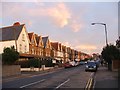
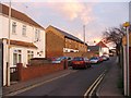
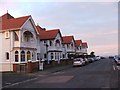
CT6 5BD is a small area with a housing stock dominated by owner-occupied properties, with 64% of homes owned by residents. The accommodation type is primarily houses, which is typical for suburban areas but contrasts with more densely populated regions. This suggests a market where properties are likely to be family homes, with limited rental activity. The area’s compact size means the housing stock is finite, potentially leading to competition among buyers. For those considering purchase, the focus would be on individual properties rather than larger developments. The presence of houses rather than flats may appeal to those seeking space and privacy. However, the limited scale of the area means buyers should consider nearby postcode clusters for broader options.
House Prices in CT6 5BD
No properties found in this postcode.
Energy Efficiency in CT6 5BD
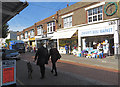
Residents of CT6 5BD have access to five retail venues, including Tesco Mortimer, Iceland Herne, and Tesco Herne, providing everyday shopping convenience. The area’s rail links to Herne Bay, Chestfield & Swalecliffe, and Whitstable stations offer easy access to larger towns and coastal attractions. While the data does not mention parks or leisure facilities, the proximity to Herne Bay’s town centre likely includes recreational options. The mix of retail and transport amenities contributes to a practical lifestyle, balancing local convenience with regional connectivity. This makes CT6 5BD suitable for those who value accessibility without sacrificing the comfort of a residential setting.
Amenities
Schools
Residents of CT6 5BD have access to two primary schools within practical reach: Herne Bay Infant School and Herne Bay Junior School. Both are rated ‘good’ by Ofsted, indicating a reliable standard of education for younger children. The presence of two primary schools suggests a well-structured educational pathway for families, covering early years through to primary level. While no secondary schools are listed, the proximity to Herne Bay’s town centre likely provides additional options. The quality of these schools is a key draw for families, offering a stable foundation for children’s learning. The ‘good’ rating reflects effective teaching and management, which is reassuring for parents seeking consistent educational outcomes.
| Rank | School | Type | Entry gender | Ages |
|---|---|---|---|---|
| 1 | Herne Bay Infant School | primary | N/A | N/A |
| 2 | Herne Bay Junior School | primary | N/A | N/A |
Explore more schools in this area
Go to Schools tabDemographics
CT6 5BD’s population of 1422 is predominantly composed of adults aged 30–64, with a median age of 47. This suggests a mature, settled community, likely with long-term residents and families. Home ownership is high at 64%, indicating a strong presence of owner-occupied properties. The area’s accommodation is primarily houses, reflecting a suburban rather than urban layout. The predominant ethnic group is White, which aligns with broader demographic trends in the region. The age profile suggests a population that may prioritise stability and proximity to essential services, such as healthcare and education. With no data on deprivation levels, the focus remains on the tangible aspects of living here: a mix of older and newer homes, a balanced age distribution, and a community that appears to value continuity.
Household Size
Accommodation Type
Tenure
Ethnic Group
Religion
Household Composition
Age
Household Deprivation
NS-SEC
Explore more demographic insights in this area
Go to Demographics tabPlanning
Planning Constraints
- Flood RiskPremium
- Ramsar Wetland SitesPremium
- Area of Outstanding Natural BeautyPremium
- Protected Nature ReservePremium
- Protected WoodlandPremium
- Crime RiskPremium