Area Overview for CT5 1JB
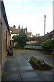
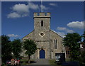
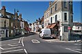
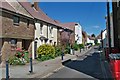
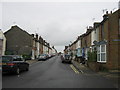
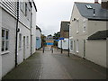
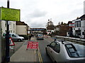
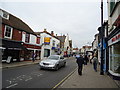
Photos of CT5 1JB

Area Information
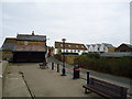
Living in CT5 1JB means residing within a very specific residential cluster in the Kent county town of Whitstable. This postcode covers an area of just 2,020 m², creating a densely populated pocket where 1,093 residents call home. The population density reaches 541,041 people/km², indicating a tightly knit living environment typical of historic coastal wards. The location sits within Gorrell, an electoral ward for Canterbury City Council that encompasses the town centre and is named after a local stream. This area is divided by the historic Canterbury and Whitstable Railway, often known as the Crab and Winkle line, which splits the ward into northern and southern sections called 'Harbour' and 'Lower Gorrell'. Daily life here is defined by proximity to town centre amenities and the unique geography shaped by the railway run. You are situated in a small community where the electric train line acts as a physical boundary, influencing local heritage and property boundaries. The tight space suggests a neighbourhood where walking distances to services are short, but the high density creates a distinct urban feel compared to the broader rural surroundings of the surrounding countryside.
- Area Type
- Postcode
- Area Size
- 2020 m²
- Population
- Not available
- Population Density
- Not available
Homes in CT5 1JB are characterised by a substantial owner-occupation rate of 57%. This figure distinguishes the area from zones with high rental turnover or a concentration of New Build apartments. The predominant accommodation type is houses, meaning the housing stock consists primarily of detached or semi-detached properties rather than flats or maisonettes. If you are looking at properties here, you are entering a market where resale liquidity depends on the traditional home value of established stock. The postcode represents a specific residential cluster where the majority of residents have a stake in the local estate. This high level of ownership often correlates with stronger community governance and more careful maintenance of the housing stock. For investors, the market focuses on letting whole houses to tenants rather than renting rooms in shared flats. The limited total area size of 2,020 m² means that house prices will reflect the scarcity of street frontage and the specific constraints of the local geography. Buyers should expect a market driven by demand for traditional family homes within a compact, high-density urban ward.
House Prices in CT5 1JB
No properties found in this postcode.
Energy Efficiency in CT5 1JB
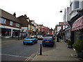
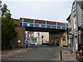
Your daily lifestyle in CT5 1JB benefits from immediate access to essential retail and transport hubs. There are five notable retail venues within practical reach, including Iceland Whitstable, Sainsburys Whitstable, and The Southern Co-operative Co. These supermarkets and shops provide a convenient range of groceries, clothing, and daily essentials without requiring a long drive. Transport is well integrated with five nearby railway stations, notably Whitstable Railway Station, Chestfield & Swalecliffe Railway Station, and Herne Bay Railway Station. This rail network connects you to the wider region efficiently. Living in Whitstable means you are close to the historic Canterbury and Whitstable Railway line that divides the local ward. The proximity to these amenities means shopping trips are short and public transport is readily available for trips beyond the borough. You benefit from a mix of traditional local trade and modern supermarket chains. The area's character as a small residential cluster ensures these amenities are walking distance for many of the 1,093 residents.
Amenities
Schools
Education options for families in CT5 1JB are anchored by one specific school listed in the immediate vicinity. Westmeads Community Infant School is a primary school located near the area. It holds an outstanding Ofsted rating, reflecting high standards in teaching and student care according to government inspections. This rating suggests a robust educational environment for young children. Since only primary education is listed in your data, you will find that secondary school choices require looking slightly further afield outside this immediate postcode cluster. The presence of an outstanding rated infant school provides a positive starting point for school age parents moving into CT5 1JB. The single listing implies a specific catchment area structure common in smaller wards where primary feeds into local comprehensive provisions. Families choosing homes here can rely on the strong performance record of Westmeads as a core local asset for early years education. The outstanding rating is a verifiable fact you can use when comparing neighbourhoods for early schooling needs.
| Rank | School | Type | Entry gender | Ages |
|---|---|---|---|---|
| 1 | Westmeads Community Infant School | primary | N/A | N/A |
Explore more schools in this area
Go to Schools tabDemographics
The community in CT5 1JB has a clearly defined demographic profile with a median age of 47 years. Adults aged between 30 and 64 years form the most common age range, suggesting a population made up of established households rather than young single occupants or retirees solely aged over 65. Home ownership stands at 57%, indicating a balanced market where over half of the population owns their property outright or with a mortgage, while the remainder likely rents or shares. Houses are the predominant accommodation type, reflecting the character of the local housing stock. The predominant ethnic group is White, which aligns with the traditional demographic composition of this specific part of Kent. These figures paint a picture of a stable, mature community. The high home ownership rate alongside the age profile implies relatively low transient movement compared to student or holiday rental hotspots. Families with grown children or couples without young dependents dominate the scene. This data suggests buyers looking for a settled environment will find a neighbourhood where long-term residents maintain a significant hold on the property.
Household Size
Accommodation Type
Tenure
Ethnic Group
Religion
Household Composition
Age
Household Deprivation
NS-SEC
Explore more demographic insights in this area
Go to Demographics tabPlanning
Planning Constraints
- Flood RiskPremium
- Ramsar Wetland SitesPremium
- Area of Outstanding Natural BeautyPremium
- Protected Nature ReservePremium
- Protected WoodlandPremium
- Crime RiskPremium