Area Overview for CT5 1HA
Photos of CT5 1HA
Area Information
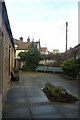
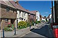
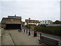
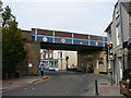
Living in CT5 1HA means residing within a small residential cluster on the outskirts of Whitstable in Kent. This specific postcode covers 1177 square metres of land and is home to a population of 1093 people. You are situated in Gorrell, an electoral ward of Canterbury City Council that historically divides its northern and southern sections with the railway line. The area includes distinct sub-sections such as the northern coastal section known as Harbour and the southern section called Lower Gorrell. Butler is part of this local landscape, defined by its proximity to the historic Canterbury and Whitstable Railway, often referred to as the Crab and Winkle line. Daily life here is shaped by this coastal location, placing you near the sea while maintaining a residential focus. The ward offers a setting where you can access the town centre yet remain within a relatively compact community. This area provides a specific snapshot of suburban life in South East England, blending historic railway assets with modern residential needs.
- Area Type
- Postcode
- Area Size
- 1177 m²
- Population
- Not available
- Population Density
- Not available
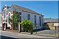
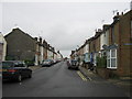
The property market in CT5 1HA is characterised by a significant owner-occupier presence. Fifty-seven per cent of homes in this postcode are owned by the residents, while the remainder are rented properties. The accommodation type data confirms that houses dominate the housing stock, rather than condominiums or purpose-built flats. This mix suggests a market aimed at families and individuals seeking stability in a suburban setting. When looking at homes in CT5 1HA, you will primarily encounter traditional family residences rather than investor-led developments. The small area size of 1177 square metres limits the sheer volume of new builds, maintaining a established character. Buyers generally seek established homes with long-term tenure rather than short-term rental opportunities. The high rate of homeownership points to a community where people remain for decades, focusing on maintenance and local improvement rather than quick turnovers. This stability often leads to well-cared-for interiors and gardens, distinguishing the estate from areas dominated by transient tenants.
House Prices in CT5 1HA
No properties found in this postcode.
Energy Efficiency in CT5 1HA
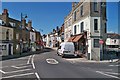
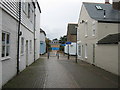
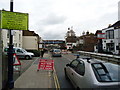
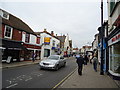
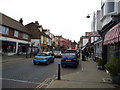
Lifestyle in CT5 1HA revolves around convenient access to practical amenities within walking or short driving distance. Retail options are immediately accessible, with five notable shops nearby. Iceland Whitstable, The Southern Co-operative Co, and Sainsburys Whitstable provide your primary needs for grocery shopping. These supermarkets offer full ranges of fresh produce and household essentials. For scheduled travel, rail connectivity places five stations within reach, including Whitstable Railway Station and Herne Bay Railway Station. You can combine daily shopping trips with commuter journeys efficiently. The area benefits from being close to the coast, given its location in the Gorrell ward which includes the Harbour sub-area. While local parks are not explicitly named in the data, the presence of nearby rail lines and town amenities creates a balanced routine. Your weekend plans could easily involve trips to the seafront or exploring Whitstable's listed buildings and cafes. Daily life here is defined by the ability to run errands locally while enjoying the broader culture of Whitstable.
Amenities
Schools
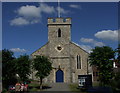
Families in CT5 1HA have access to high-quality education within the Gorrell ward. The nearest listed school is Westmeads Community Infant School, which serves as a primary institution for young children. Current data rates this school as outstanding, indicating a strong educational standard. This institution is the only named school provided for your immediate vicinity, highlighting a focused primary education option close to your home. The lack of secondary school names in the immediate data set suggests you should plan further commutes for older children or rely on neighbouring districts for secondary provision. The outstanding rating of Westmeads provides reassurance for parents prioritising early childhood education. You can expect rigorous academic standards and a supportive learning environment at this level. The school's location in the wider Gorrell ward connects it to local families seeking reliable schooling options. For those considering moving to CT5 1HA, this school represents a key amenity driving family interest in the area.
| Rank | School | Type | Entry gender | Ages |
|---|---|---|---|---|
| 1 | Westmeads Community Infant School | primary | N/A | N/A |
Explore more schools in this area
Go to Schools tabDemographics
The community in CT5 1HA reflects a settled demographic with a median age of 47 years. Adults between 30 and 64 years constitute the most common age range for residents. This age profile suggests a neighbourhood where families and established households form the bulk of the population. Home ownership stands at 57 per cent, indicating that more than half of the residents own their properties outright or with a mortgage. The predominant ethnic group is White, which is consistent with many suburban areas in Kent. The local accommodation type consists largely of houses, offering standing families detached or semi-detaged homes with gardens. You will find fewer flats or bungalows compared to urban centres, matching the architectural style of the post-war suburbs. The population density reaches 928,654 people per square kilometre within this specific cluster, creating a tight-knit environment. With over 1000 residents in such a defined space, you experience a strong sense of locality without the chaos of a city centre.
Household Size
Accommodation Type
Tenure
Ethnic Group
Religion
Household Composition
Age
Household Deprivation
NS-SEC
Explore more demographic insights in this area
Go to Demographics tabPlanning
Planning Constraints
- Flood RiskPremium
- Ramsar Wetland SitesPremium
- Area of Outstanding Natural BeautyPremium
- Protected Nature ReservePremium
- Protected WoodlandPremium
- Crime RiskPremium