Area Overview for CT4 6QP
Photos of CT4 6QP
Area Information
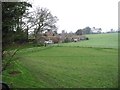
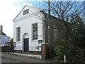
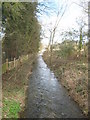
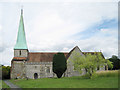
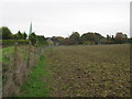
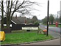
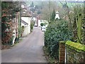
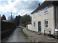
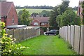
CT4 6QP is a small, tightly knit residential cluster in the heart of Barham, a village in Kent’s scenic countryside. With a population of 1,345 and a density of 164 people per square kilometre, it balances rural tranquillity with practical convenience. Barham’s history as a Saxon settlement adds character, with its ancient church and rolling Downs landscape defining the area’s charm. Daily life here is shaped by proximity to Canterbury, just 10 km away, offering easy access to cultural and commercial hubs. The village retains its historic feel, with winding lanes and traditional architecture, yet benefits from modern amenities. Residents enjoy a mix of local shops, rail links, and open spaces, making it ideal for those seeking a peaceful yet connected lifestyle. The area’s compact size means a strong sense of community, where familiarity with neighbours is common. For buyers, CT4 6QP offers a rare blend of heritage, low population density, and proximity to larger cities, appealing to those prioritising both seclusion and accessibility.
- Area Type
- Postcode
- Area Size
- Not available
- Population
- 1345
- Population Density
- 164 people/km²
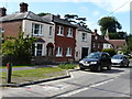
CT4 6QP is predominantly an owner-occupied area, with 89% of homes owned outright. The accommodation type is exclusively houses, which is unusual for a small postcode area and suggests a focus on family homes or larger properties. This contrasts with nearby urban areas where flats or apartments might dominate. The limited number of properties reflects the area’s rural nature and compact size, meaning the housing stock is likely to be established rather than new-build. For buyers, this creates a niche market where properties are scarce but may hold long-term value. The high home ownership rate also implies lower rental demand, making it less attractive to investors seeking yield. Those considering purchase should view the area as a place for settled living rather than speculative investment, with potential for stable property values due to its low population density and historical appeal.
House Prices in CT4 6QP
No properties found in this postcode.
Energy Efficiency in CT4 6QP
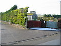
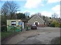
Living in CT4 6QP offers a mix of practical amenities and rural charm. Within reach are five retail outlets, including Co-op Aylesham, Co-op Shepherdswell, and Sainsburys Canterbury Old, ensuring everyday shopping needs are met. The village’s rail and metro stations provide easy access to nearby towns and cities, while the surrounding Kent Downs offer scenic walks and outdoor activities. The historic character of Barham, with its listed church and ancient landscapes, adds to the area’s appeal. Residents can enjoy a quiet, community-focused lifestyle with the convenience of nearby services. The limited number of amenities reflects the area’s small size, but this also fosters a close-knit environment where local businesses and traditions thrive.
Amenities
Schools
The primary school nearest to CT4 6QP is Barham Church of England Primary School, rated ‘good’ by Ofsted. This institution serves the local community, offering education for younger children within the village. While no secondary schools are listed in the data, the presence of a primary school with a strong rating is a significant draw for families. The school’s proximity to homes reduces commuting time for parents and ensures children are educated in a familiar, local environment. However, families requiring secondary education may need to look further afield, potentially increasing travel time. The single school listed suggests a focus on primary education, which aligns with the area’s demographic profile of older residents and families with younger children.
| Rank | School | Type | Entry gender | Ages |
|---|---|---|---|---|
| 1 | Barham Church of England Primary School | primary | N/A | N/A |
Explore more schools in this area
Go to Schools tabDemographics
The population of CT4 6QP skews towards adults aged 30–64, with a median age of 47. This suggests a mature, stable community, likely with established careers and family structures. Home ownership is high at 89%, indicating a predominantly owner-occupied area with limited rental properties. The accommodation type is primarily houses, reflecting a suburban or semi-rural layout rather than flats or apartments. The predominant ethnic group is White, with no specific data on other demographics. This profile implies a low turnover of residents and a focus on long-term living. The absence of detailed diversity statistics means the community’s social composition is largely homogeneous, which may appeal to those seeking familiarity and continuity. The age range also suggests a balance between active professionals and retirees, contributing to a steady local economy.
Household Size
Accommodation Type
Tenure
Ethnic Group
Religion
Household Composition
Age
Household Deprivation
NS-SEC
Explore more demographic insights in this area
Go to Demographics tabPlanning
Planning Constraints
- Flood RiskPremium
- Ramsar Wetland SitesPremium
- Area of Outstanding Natural BeautyPremium
- Protected Nature ReservePremium
- Protected WoodlandPremium
- Crime RiskPremium