Area Overview for CT4 6AA
Photos of CT4 6AA


Area Information
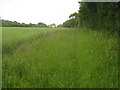
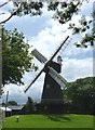
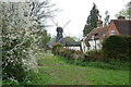
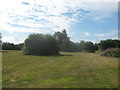
CT4 6AA defines a specific residential cluster within the village of Stelling Minnis, a parish in the Folkestone and Hythe district of Kent. You are locating within a 4,313 square metre site that accommodates 1,976 residents, creating a population density of 58 people per square kilometre. This postcode lies approximately 13 kilometres south of Canterbury, situated near the historic Roman road known as Stone Street. The landscape is defined by the Minnis, a vast 124-acre common land that remains one of the last unenclosed manorial commons in Kent. This open heathland has existed since Saxon times, originally serving as pasture under the term *maennes*. The area retains a distinct medieval character, acting as a monument to historical struggles over common land rights that have persisted for centuries. Your daily life here involves traversing open countryside rather than typical urban streets. The setting feels remote yet accessible, offering a quiet escape from the pace of nearby towns while remaining within practical reach of Canterbury. Living in CT4 6AA means embracing a rural existence centred around St Mary the Virgin Church, a Grade I listed building dating back to the 13th century. The village is defined by its open spaces and historical significance rather than modern high-density development. You are entering an environment where history is physically present in the unenclosed common and the ancient church, shaping a community identity rooted in landscape and heritage.
- Area Type
- Postcode
- Area Size
- 4313 m²
- Population
- 1976
- Population Density
- 58 people/km²
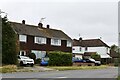
The housing market in CT4 6AA is characterised by an overwhelming dominance of owner-occupiers, with 83 per cent of properties held in this category. This ownership model indicates a stable market where locals, rather than short-term renters, form the core of the community. The area consists entirely of houses, reflecting its rural village status and lack of urban apartment blocks. This configuration suits buyers seeking detached or semi-detached homes with potential for expansion or conservation conversion. Given the total population of 1,976 and a very small area size of 4,313 square metres, supply is inherently limited. This scarcity often places value on individual properties. The high homeownership rate suggests that the local economy supports family households or retirees who prefer to stay put. Buyers looking at CT4 6AA should expect competition as such small rural clusters rapidly fill up. The practical reality is that owner-occupiers dominate the scene, creating a neighbourhood where sellers tend to be residents moving on rather than professional landlords. This environment reduces rental yield potential for investors but offers peace of mind for those wishing to buy and settle permanently. The housing stock is strictly residential, lacking the mixed-use complexity found in larger towns.
House Prices in CT4 6AA
Showing 13 properties
| Address | Type | Beds | Baths | Last Sale Price | Last Sale Date | |
|---|---|---|---|---|---|---|
| 3 Minnis Green, Stelling Minnis, CT4 6AA | Terraced | 3 | 1 | - | - | |
| 1 Minnis Green, Stelling Minnis, CT4 6AA | Terraced | 3 | 1 | - | - | |
| 10 Minnis Green, Stelling Minnis, CT4 6AA | Bungalow | 4 | - | - | - | |
| 8 Minnis Green, Stelling Minnis, CT4 6AA | Bungalow | - | - | - | - | |
| 4 Minnis Green, Stelling Minnis, CT4 6AA | Flat | - | - | - | - | |
| 12 Minnis Green, Stelling Minnis, CT4 6AA | Bungalow | - | - | - | - | |
| 9 Minnis Green, Stelling Minnis, CT4 6AA | Bungalow | - | - | - | - | |
| 13 Minnis Green, Stelling Minnis, CT4 6AA | Bungalow | - | - | - | - | |
| 6 Minnis Green, Stelling Minnis, CT4 6AA | Flat | - | - | - | - | |
| 11 Minnis Green, Stelling Minnis, CT4 6AA | Bungalow | - | - | - | - |
Energy Efficiency in CT4 6AA
Residents of CT4 6AA have practical access to essential amenities located just beyond the immediate rural setting. For daily shopping, Co-op Wye and Co-op Sellindge are identified as the nearest retail outlets for your basic needs. Sainsburys Canterbury Old provides a larger supermarket option further out for bulk purchases. Four railway stations lie within reasonable practical reach, including Chartham Railway Station, Chilham Railway Station, and Wye Railway Station. These rail links offer connections to larger transport hubs and allow you to commute without driving every day. Your lifestyle balances rural quiet with accessible services. You can walk to the village centre for essentials and transfer to rail lines for longer journeys. This arrangement supports a low-carbon living model where local shops cover most requirements. The proximity to Canterbury Old means you do not need to travel far for extended retail experiences. Daily life involves this rhythm of local management supplemented by efficient public transport. You have the convenience of a village setting without the isolation of the countryside.
Amenities
Schools
Families considering schools near CT4 6AA have two primary options located close to the village. Stelling Minnis Church of England Primary School operates as a primary institution and holds a good Ofsted rating. Elham Church of England Primary School also functions as a primary school and similarly carries a good Ofsted rating. Both schools serve the immediate community, offering state education with proven standards of teaching and care. The absence of secondary schools within the immediate data set implies that older students must travel to larger towns for comprehensive or grammar education. This arrangement is typical for villages of Stelling Minnis size, where residents rely on established primaries as foundations before transferring to larger facilities. If you are moving here, these two primary schools are the foundational educational resources for children born or living in the CT4 6AA postcode. The consistent good ratings across both primary institutions suggest a reliable educational network. You do not need to look further for early years and primary education, as the local provision meets high standards. The presence of two reputable primaries supports the community's need for local schooling facilities.
| Rank | School | Type | Entry gender | Ages |
|---|
Explore more schools in this area
Go to Schools tabDemographics
The community inhabiting CT4 6AA skews significantly towards mature adults, with a median age of 47 years. Most residents fall within the 30 to 64-year-old age range, indicating a population without young children or elderly retirees as the dominant groups. Homeownership is the prevailing property status, with 83 per cent of dwellings occupied by owners. This high rate suggests stability and long-term settlement within this specific postcode area. The accommodation types are exclusively houses, confirming the absence of flats or apartments in this particular cluster. The predominant ethnic group among residents is White, maintaining the traditional demographic profile associated with the East Kent region. With a low population density of 58 people per square kilometre, the local feel remains intimate and uncluttered. The demographic data paints a clear picture of a settled community where long-term ownership is the norm. You are looking at a neighbourhood where families and established households have deep roots. The age profile implies a mature population likely interested in permanent residence rather than transient renting. The high proportion of homeowners aligns with the nature of the housing stock and the rural setting. Living here means joining a group of similarly situated residents who value stability over rapid turnover.
Household Size
Accommodation Type
Tenure
Ethnic Group
Religion
Household Composition
Age
Household Deprivation
NS-SEC
Explore more demographic insights in this area
Go to Demographics tabPlanning
Planning Constraints
- Flood RiskPremium
- Ramsar Wetland SitesPremium
- Area of Outstanding Natural BeautyPremium
- Protected Nature ReservePremium
- Protected WoodlandPremium
- Crime & SafetyPremium