Area Overview for CT2 8UB
Photos of CT2 8UB


Area Information
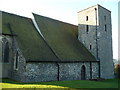
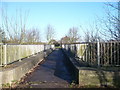
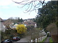
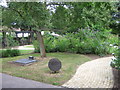
CT2 8UB is a small, tightly knit residential postcode in the parish of Blean, Kent, just 2 miles north-west of Canterbury. With a population of 1,604, it reflects the quiet, rural character of the area, nestled within a landscape defined by ancient woodlands and historic ties to the region. The Blean itself is a vast expanse of ancient forest, covering over 11 square miles, and remains one of Kent’s most significant wooded areas. Living here means proximity to Canterbury’s cultural and economic hubs, yet with the tranquillity of a rural setting. The area lies on the Whitstable railway line, offering convenient links to nearby towns. Daily life here is shaped by the surrounding natural environment, with the parish’s history of woodland management and ecclesiastical influence still evident in its landscape. The community is predominantly home-owning, with a median age of 47, suggesting a stable, established population. For those seeking a balance between accessibility and seclusion, CT2 8UB offers a distinct blend of historical depth and modern practicality.
- Area Type
- Postcode
- Area Size
- Not available
- Population
- Not available
- Population Density
- Not available
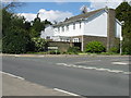
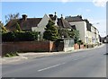
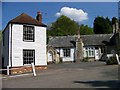
CT2 8UB is a small, owner-occupied area with 72% of properties in private hands, contrasting with rental markets that dominate many urban zones. The accommodation type is exclusively houses, reflecting a low-density, suburban or rural layout typical of smaller postcode areas. This suggests limited availability of flats or apartments, which may appeal to buyers seeking traditional family homes or those prioritising space. The area’s proximity to Canterbury—reachable via the Whitstable railway line—adds to its appeal for commuters or those seeking a base near a larger town. However, the small size of the postcode means housing stock is limited, and buyers should consider nearby areas for broader options. The focus on owner-occupation implies a stable market with long-term residents, though specific property price trends or investment potential are not detailed in the data.
House Prices in CT2 8UB
No properties found in this postcode.
Energy Efficiency in CT2 8UB
Residents of CT2 8UB have access to a range of nearby amenities, including five retail outlets such as Co-op University of, Co-op Kent, and Sainsburys Canterbury St. These shops provide everyday essentials, reducing the need for long trips to larger centres. The area’s rail network, with five stations including Canterbury West and Chartham, ensures easy access to public transport for shopping, commuting, or leisure. While the data does not mention parks or leisure facilities, the surrounding Blean woodland offers opportunities for walking or nature-based recreation. The mix of retail and rail connectivity suggests a practical, convenience-driven lifestyle, with the area’s small size encouraging a close-knit community feel.
Amenities
Schools
The nearest school to CT2 8UB is St Edmund’s School Canterbury, an independent institution. While no Ofsted rating is provided, the presence of an independent school suggests the area may attract families seeking alternative educational options. The absence of state schools in the immediate vicinity means families must consider travel time to nearby towns for public education. Independent schools often cater to specific educational philosophies or specialisms, which may align with the preferences of the area’s predominantly home-owning, middle-aged population. However, the limited school options highlight the need for careful planning when assessing the suitability of CT2 8UB for families with children.
| Rank | School | Type | Entry gender | Ages |
|---|---|---|---|---|
| 1 | St Edmund's School Canterbury | independent | N/A | N/A |
Explore more schools in this area
Go to Schools tabDemographics
The population of CT2 8UB is 1,604, with a median age of 47 and the most common age range being adults aged 30–64. This suggests a mature, settled community with limited presence of younger or elderly demographics. Home ownership is high at 72%, indicating a strong preference for long-term residency over rental properties. The accommodation type is predominantly houses, reflecting a low-density, suburban or rural housing stock. The predominant ethnic group is White, with no specific data provided on other ethnicities or diversity metrics. While the data does not include deprivation scores, the high home ownership and stable age profile suggest a community with relatively consistent access to resources and services. The absence of detailed diversity statistics means broader demographic trends remain unexplored, but the area’s character is clearly shaped by its older, predominantly White, home-owning population.
Household Size
Accommodation Type
Tenure
Ethnic Group
Religion
Household Composition
Age
Household Deprivation
NS-SEC
Explore more demographic insights in this area
Go to Demographics tabPlanning
Planning Constraints
- Flood RiskPremium
- Ramsar Wetland SitesPremium
- Area of Outstanding Natural BeautyPremium
- Protected Nature ReservePremium
- Protected WoodlandPremium
- Crime RiskPremium