Area Overview for CT2 0AB
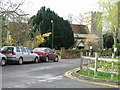
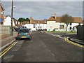
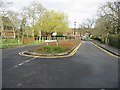
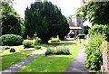
Photos of CT2 0AB

Area Information
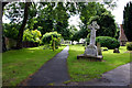
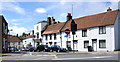
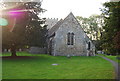
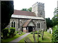
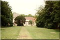
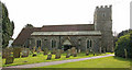
CT2 0AB is a small, tightly knit residential area in Kent, encompassing the village of Sturry and its surrounding hamlets. With a population of 1,438 spread across 8.9 hectares, it retains a rural character despite its proximity to Canterbury, just 3 miles away. The area is defined by its historical roots, including the River Stour and remnants of Roman roads, and features a mix of arable farmland, market gardens, and historic buildings. Daily life here is shaped by its role as a dormitory village for Canterbury, with residents often commuting to the city for work. The community is predominantly composed of middle-aged adults, many of whom own their homes. Sturry’s charm lies in its blend of historical significance—such as the Grade I listed St Nicholas Church—and practical amenities like nearby rail links and retail outlets. While the area is small, it offers a quiet, self-contained lifestyle with easy access to larger urban centres.
- Area Type
- Postcode
- Area Size
- 8.9 hectares
- Population
- 1438
- Population Density
- 599 people/km²
CT2 0AB is primarily an owner-occupied area, with 71% of properties owned by residents rather than rented. The housing stock consists largely of houses, which aligns with the area’s rural and semi-suburban character. Given the small size of the postcode—just 8.9 hectares—the property market is limited in scale, with few new developments. This scarcity means that homes here are likely to be long-standing, with historical or architectural features. For buyers, this presents both opportunities and challenges: properties may offer unique character but could be constrained by limited availability. The proximity to Canterbury also means that some residents commute, though the area itself is self-contained. Buyers should consider the small size of the postcode when searching for properties, as the immediate surroundings may hold more options.
House Prices in CT2 0AB
No properties found in this postcode.
Energy Efficiency in CT2 0AB
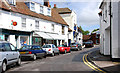
Living in CT2 0AB offers a mix of rural tranquillity and practical amenities. The area’s retail options include a Co-op, Iceland, and M&S, providing essentials and convenience for daily life. Rail stations such as Sturry and Canterbury East offer easy access to nearby towns, while the village’s historic character includes Grade I listed buildings and the River Stour. The surrounding landscape features arable farmland and market gardens, contributing to a peaceful, low-density environment. Despite its small size, the area’s proximity to Canterbury ensures access to larger urban facilities. The blend of historic architecture, accessible transport, and rural scenery creates a lifestyle that balances quiet living with connectivity.
Amenities
Schools
The nearest school to CT2 0AB is the independent Junior King’s School, which serves the area’s educational needs. As an independent institution, it may offer specialised curricula or facilities not found in state schools. However, the data does not provide Ofsted ratings or additional details about the school’s performance. The presence of a single school type—private—suggests that families in CT2 0AB may have specific preferences for independent education. While this could appeal to those seeking alternative schooling, it also means the area lacks a range of state school options. Parents should consider whether the school’s offerings align with their children’s needs, particularly given the limited number of nearby educational institutions.
| Rank | School | Type | Entry gender | Ages |
|---|---|---|---|---|
| 1 | Junior King's School | independent | N/A | N/A |
Explore more schools in this area
Go to Schools tabDemographics
The population of CT2 0AB has a median age of 47, with the majority of residents aged between 30 and 64. This suggests a community of established professionals and families, many of whom are likely to be homeowners, with 71% of homes owned outright. The area is predominantly composed of houses, reflecting a traditional, low-density housing stock. The predominant ethnic group is White, indicating a homogenous demographic profile. With a population density of 599 people per square kilometre, the area is moderately populated for its size, balancing rural spaciousness with a sense of community. This density supports local amenities but does not create overcrowding. The age profile suggests a stable, long-term resident base, with fewer young families or elderly populations compared to other areas.
Household Size
Accommodation Type
Tenure
Ethnic Group
Religion
Household Composition
Age
Household Deprivation
NS-SEC
Explore more demographic insights in this area
Go to Demographics tabPlanning
Planning Constraints
- Flood RiskPremium
- Ramsar Wetland SitesPremium
- Area of Outstanding Natural BeautyPremium
- Protected Nature ReservePremium
- Protected WoodlandPremium
- Crime RiskPremium