Area Overview for CT19 4EX
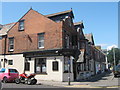
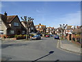
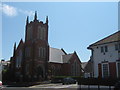
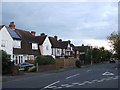
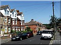
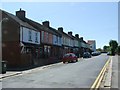
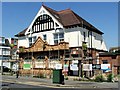
Photos of CT19 4EX


Area Information
Living in CT19 4EX means being part of a small, tightly knit residential cluster in Folkestone, Kent. This area sits on the English Channel coastline, blending coastal charm with accessible connectivity. With a population of 1,728, it is a compact community where daily life revolves around local amenities, historic sites, and proximity to major transport hubs. Folkestone’s heritage as a 7th-century fishing village and 19th-century port is still evident in its architecture and landmarks, such as the Church of St Martin and the Folkestone War Memorial. Residents benefit from nearby retail, rail, and ferry services, including the Folkestone Eurotunnel Terminal, which links the area to continental Europe. The postcode’s small size means a strong sense of local identity, with community life centred on nearby schools, parks, and the coastal promenade. For buyers, CT19 4EX offers a balance of historical character and modern convenience, ideal for those seeking a quieter, family-oriented lifestyle near the coast.
- Area Type
- Postcode
- Area Size
- Not available
- Population
- 1728
- Population Density
- Not available
The property market in CT19 4EX is characterised by a high rate of home ownership (63%) and a predominance of houses. This suggests a market skewed towards owner-occupied homes rather than rental properties, which is typical of smaller, residential postcodes. The focus on houses rather than flats or apartments indicates a demand for larger, family-friendly properties, potentially appealing to buyers seeking space and stability. Given the area’s small size, the housing stock is likely limited, making properties in CT19 4EX relatively scarce compared to larger towns. Buyers should consider the proximity to transport links, such as Folkestone’s rail stations and the Eurotunnel Terminal, which could enhance the area’s appeal for commuters or those requiring easy access to regional centres. The market’s compact nature may also mean limited scope for new developments, reinforcing the value of existing homes.
House Prices in CT19 4EX
No properties found in this postcode.
Energy Efficiency in CT19 4EX
Residents of CT19 4EX enjoy a range of amenities within practical reach, including retail options like Co-op Cheriton, M&S Cheriton, and Tesco Folkestone, ensuring everyday shopping needs are met. The area’s proximity to rail stations, such as Folkestone West and Sandling, and the Eurotunnel Terminal provides seamless access to transport networks, whether for commuting or leisure travel. The nearby Lympne Airport offers additional connectivity for those requiring flight access. For leisure, the coastal promenade and historic sites like the Church of St Martin and Folkestone War Memorial provide cultural and recreational opportunities. The mix of retail, transport, and historical landmarks creates a convenient, characterful lifestyle, blending practicality with the charm of a coastal town.
Amenities
Schools
Residents of CT19 4EX have access to a range of educational institutions, including Pent Valley Technology College, a primary school, and Turner Free School, an academy rated ‘good’ by Ofsted. Birchwood, another local school, serves as a supplementary option. The presence of both a primary school and an academy provides families with choices, from early education to secondary schooling. Turner Free School’s ‘good’ rating suggests a reliable standard of teaching, which is crucial for parents prioritising academic outcomes. The variety of school types reflects a balanced approach to education, combining traditional structures with alternative models. For families, this mix ensures flexibility, whether they prefer a state school, academy, or other educational pathways. The proximity of these schools to the area reinforces CT19 4EX’s suitability for households with children.
| Rank | School | Type | Entry gender | Ages |
|---|
Explore more schools in this area
Go to Schools tabDemographics
The community in CT19 4EX is predominantly composed of adults aged 30–64, with a median age of 47. This suggests a mature, stable population, likely focused on long-term residency. Home ownership is high at 63%, indicating a mix of family homes and established residents. The accommodation type is primarily houses, reflecting a residential area with larger properties rather than flats or apartments. The predominant ethnic group is White, though no specific diversity data is provided. The age profile and ownership levels suggest a community with fewer young families or transient residents, which may influence local services and amenities. The absence of significant deprivation data implies a relatively even distribution of resources, though this remains unquantified. For buyers, this demographic profile aligns with a low-maintenance, owner-occupied market where properties are likely to be well-maintained and occupied long-term.
Household Size
Accommodation Type
Tenure
Ethnic Group
Religion
Household Composition
Age
Household Deprivation
NS-SEC
Explore more demographic insights in this area
Go to Demographics tabPlanning
Planning Constraints
- Flood RiskPremium
- Ramsar Wetland SitesPremium
- Area of Outstanding Natural BeautyPremium
- Protected Nature ReservePremium
- Protected WoodlandPremium
- Crime RiskPremium