Area Overview for CT17 9UJ
Photos of CT17 9UJ


Area Information
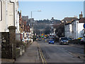
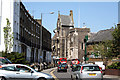
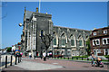
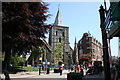
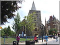
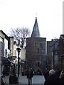
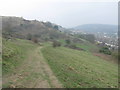
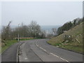
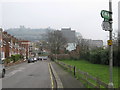
Living in CT17 9UJ means being part of a compact residential cluster in Dover, Kent, a historic port town on the Dover Strait. With a population of 2,037 and a density of 544 people per square kilometre, this area blends small-town charm with strategic coastal location. Dover’s significance dates to Roman times, when it was known as Dubris, and its medieval architecture, including St Mary the Virgin Church, reflects centuries of history. The area is served by four nearby rail stations, including Dover Priory and Kearsney, and two ferry terminals, offering easy access to mainland Europe. Daily life here is shaped by proximity to retail hubs like Asda Dover and Iceland St James Retail Park, while the community’s median age of 47 suggests a mature demographic. Families benefit from schools such as Aycliffe Community Primary School, rated good by Ofsted, and independent options like Threshold Learning Centre. The area’s compact size means amenities are within practical reach, but its small population also means a close-knit, slower-paced environment.
- Area Type
- Postcode
- Area Size
- Not available
- Population
- 2037
- Population Density
- 544 people/km²
The property market in CT17 9UJ is characterised by a 39% home ownership rate, with houses being the predominant accommodation type. This suggests a mix of owner-occupied homes and rental properties, though the relatively low home ownership percentage indicates a significant portion of the housing stock is rented. The focus on houses rather than flats or apartments points to a suburban or semi-rural setting, likely appealing to families seeking space. Given the area’s small size and limited data on property availability, buyers should consider the proximity to Dover’s amenities, including retail and transport links, as key factors. The compact nature of the postcode may limit property diversity, but the presence of nearby rail stations and ferry terminals could enhance its appeal for commuters or those prioritising connectivity.
House Prices in CT17 9UJ
No properties found in this postcode.
Energy Efficiency in CT17 9UJ
Residents of CT17 9UJ enjoy a range of amenities within practical reach, including five retail venues such as Iceland St James Retail Park and Asda Dover, ideal for grocery shopping. The area’s proximity to Dover’s historic sites, like St Mary the Virgin Church and Dover Castle, adds cultural value to daily life. Four rail stations and two ferry terminals provide easy travel, while two metro stations, including Eythorne and Shepherdswell, offer additional transport links. The mix of retail, transport, and historical landmarks creates a convenient yet characterful lifestyle. However, the small population means leisure options are limited to nearby towns. The presence of schools and the strategic coastal location enhance the area’s appeal, though its compact size may not suit those seeking extensive local amenities.
Amenities
Schools
Residents of CT17 9UJ have access to Aycliffe Community Primary School, a state-funded primary school with a good Ofsted rating, and Threshold Learning Centre, an independent educational institution. The coexistence of state and independent schools provides families with options, whether they prioritise public education or seek alternative curricula. Aycliffe’s good rating suggests reliable teaching standards, while Threshold Learning Centre may cater to specific educational preferences or higher fees. The proximity of these schools to the area ensures convenience for parents, though the lack of secondary schools in the immediate vicinity may require travel to nearby towns. The mix of school types reflects Dover’s broader educational landscape, balancing accessibility with choice.
| Rank | School | Type | Entry gender | Ages |
|---|
Explore more schools in this area
Go to Schools tabDemographics
CT17 9UJ has a median age of 47, with the majority of residents aged 30–64, indicating a mature, established community. Home ownership stands at 39%, suggesting a mix of owner-occupied properties and rental units. The predominant accommodation type is houses, reflecting a suburban or semi-rural character. The White ethnic group constitutes the largest demographic, though no specific data on diversity beyond this is provided. The low population density of 544 people per square kilometre implies spacious living conditions compared to urban areas. However, the lack of detailed deprivation data means it is unclear how economic factors influence quality of life. The age profile suggests a community with stable employment and long-term residency, though the relatively low home ownership rate may indicate a reliance on rental markets or shared housing.
Household Size
Accommodation Type
Tenure
Ethnic Group
Religion
Household Composition
Age
Household Deprivation
NS-SEC
Explore more demographic insights in this area
Go to Demographics tabPlanning
Planning Constraints
- Flood RiskPremium
- Ramsar Wetland SitesPremium
- Area of Outstanding Natural BeautyPremium
- Protected Nature ReservePremium
- Protected WoodlandPremium
- Crime RiskPremium